Application information for resource consent applications of public interest.
The application seeks to enable the relocation of the Rolling Meadows festival from a site at Waipara to this rural site closer to the city.
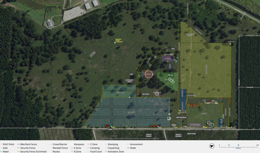
They seek consent for a three-year period for up to 10,000 ticketholders each year. The festival is predominantly a music festival held across three stages (A to C) and provides for up to 5000 ticket holders to camp on site, utilising temporary camping facilities for the duration of the event.
Campers are not permitted to take any cooking equipment onto the site, and they leave their vehicles on arrival in an inaccessible dedicated parking area for the duration of the event. Campers are only allowed out to access vehicles with supervision or if they are departing the site.
A dedicated food caravan area is proposed centrally on site alongside Stages B and C, chill-out tents, a skate facility and activation zones (sponsor areas). Day ticket holders do not have access to the camping area. A site plan showing the proposed layout can be found on page 47 of the Rolling Meadows application [PDF, 135 MB].
The site is a large site, close to the size of South Hagley Park (70.507 ha). Only a portion of the site is proposed to be utilised for the event, as shown on the site plan. A detailed version of the site plan taken from the RFI response 1 October Appendix 8 is attached as Appendix 1.
There have been various iterations of the proposal, and a compilation of the application is provided, which excludes much of the interim documentation and includes the revised proposal for which consent is now sought. The RFI response submitted on 1 October includes final versions of key documents.
Management of festival and other traffic on Lower Styx Road from 7am on 29 December to 4pm on 1 January would be in accordance with an approved (by Council) Traffic Management Plan (TMP). The TMP includes two modes of operation.
In summary, the site entry is via an access toward the northwestern end of the site, and all vehicles leave with a left turn only via an exit toward the middle of the site’s road frontage.
When the event traffic is not resulting in queuing to enter the site, traffic is managed by signage, road cones, narrowing lane width, reduced speeds and STMS supervision. When queuing to access the site occurs, manually operated traffic lights will operate to ensure straight through traffic continues to flow safely while allowing event traffic to safely enter the site from both the north and the south.
At the northern extent of the site is a large area dedicated to staff and ticket holder car parking, which is set back some 200 metres from the road. The crossings into the site, track and pick up/drop off (PUDO) area will be formed with compacted AP40 to ensure they are fit for purpose in any weather.
The site layout seeks to get all vehicles off the road and onto the site as efficiently as possible, so once a vehicle has entered, it will feed into one of nine lanes, six to the left will enter the car park, and the other three lead to a dedicated PUDO facility some 150m long and 25m wide.
The car park is grassed and is accepted as able to accommodate up to 3600 car parking spaces, which are accessed via a one-way system with parking managed by event staff. The PUDO comprises four adjoining lanes of spaces for buses, taxis (blue cars on the figure below) and ride share/private cars (black cars on the figure below).
Two pedestrian crossings and defined and coned off pedestrian areas between the PUDO vehicle pull-in spaces are provided to separate vehicles and pedestrians as much as possible, with connections then provided to a 10m wide pedestrian way that directs all pedestrians to the event ticketing gates. The PUDO would be actively managed by event staff.
Resources
- s104 Decision [PDF, 595 KB]
- Approved Consent Plans [PDF, 6.7 MB]
- Event Management Plan - Revision 7 - 26.09.2025 [PDF, 6.4 MB]
- Alcohol Management Plan - Revision 5 - 26.09.2025 [PDF, 5.2 MB]
- Noise Management Plan - Revision 6 - 16.10.2025 [PDF, 3.6 MB]
- Acoustic Assessment - Revision 14 - 16.10.2025 [PDF, 30 MB]
- Traffic Management Plan - 22.09.2025 [PDF, 6.5 MB]
- Application Amendment 16.10.2025 [PDF, 33 MB]
- s95 Notification Decision and Appendices [PDF, 17 MB]
- Application
Sign up for updates on Portlink Industrial Park

Portlink update: 11 April 2025
The Environment Court has made its final decision on whether container stacks at the Portlink Industrial Park are buildings and, therefore, subject to the 11m building height limit. The Court’s final decision is the same as its interim decision, issued 18 December 2024, that container storage/transit activity (either individually or stacked), as currently undertaken on this particular site, are not in the District Plan's definition of buildings. Please find attached the Interim and Final Decisions of the Environment Court.
As a result of this decision, there is no limit under the District Plan on the height that containers can be stacked at the Portlink site outside a defined green space. The owner must comply with the conditions of the resource consent previously granted by the Council. These include landscaping, a noise management plan and subdivision conditions.
The Court has now closed its file without awarding costs to the applicants. This is because the parties acted reasonably in seeking a resolution of the issue.
The appeals and the abatement notices have now been withdrawn because the Court's declaration has determined the issues.
Final decision [PDF, 167 KB]
Portlink update: 23 December 2024
The environment court has made an interim decision on whether container stacks at the Portlink Industrial Park are buildings and, therefore, subject to the 11m building height limit.
The Court's interim decision is that container storage/transit activity (either individually or stacked), as currently undertaken on this particular site, is not in the District Plan's definition of buildings.
As a result of this decision, there is no limit under the District Plan on the height at which containers can be stacked at the Portlink site.
The owner must comply with the conditions of the resource consent previously granted by the Council. These include landscaping, a noise management plan and subdivision conditions.
The Court will issue its final decision next year after further work by the parties' lawyers on detailed drafting recommendations for the Court's Declarations.
Interim decision [PDF, 424 KB]
RMA/2024/517 s357 objection hearing live stream
Resource consent RMA/2022/3611
An independent commissioner has granted the resource consent for Portlink Industrial Park as a non-notified application.
Appeal rights
Resource consent
The applicant lodged an objection under the Resource Management Act to the conditions imposed under the resource consent. The objection was considered by an Independent Commissioner and was upheld.
As a result:
- The noise conditions have been removed and the applicant has instead volunteered a condition which requires the container operator of the site to undertake a noise management plan. There is still provision in the consent for the 2.4-metre acoustic fence, as well as a requirement to comply with the District Plan's noise standards.
- A condition that restricted shipping containers and/or buildings to a height of 11 metres has been amended so that it applies to buildings only. Whether containers are deemed to be a building and subject to the 11-metre height limit is the subject of an application for a declaration made to the Environment Court.
Because the Independent Commissioner has made a decision about the objection, the consent is now operative and the applicant is required to comply with the updated conditions.
Certificate of Compliance
The applicant has also appealed the decisions to decline the certificates of compliance and to issue an abatement notice that requires the applicant to comply with District Plan Rules as they relate to building height in the zone. The applicant has applied to the Environment Court for an Order that the abatement notice not be enforced until after the appeals are decided by the Court.
Environment Court Declaration
The Portlink Industrial Park occupier and the landowner have filed in Court a request for the Court to make a declaration in the correct interpretation of the District Plan – in particular, whether containers are within the definition of a building. If they are, they are subject to the rules in the District Plan that apply to buildings, including maximum permitted heights.
The Council asked the Court to direct that the applications for declarations should be served on the neighbouring property owners.
The Environment Court has decided that service on those directly affected by the application should not go more widely than the Council.
Please note the sole issue in this declaration case is the legal interpretation question of whether stacked containers are in the definition of building in the District Plan. Other concerns – such as noise, lights, hours of operation, vibrations, or the Council’s enforcement practices – are not considered in this case.
View a copy of the Environment Court’s decision [PDF, 186 KB].
Get in touch and stay updated
Our compliance staff are responding to complaints and answering queries. If you have an urgent complaint about operations on the site such as noise, please phone 03 941 8999.
If you have any questions about the Resource Consent process, please contact Mark Stevenson, Head of Planning and Consents: Mark.Stevenson@ccc.govt.nz or 03 941 5583.
Resource Consent application resources
Download a copy of the amended application [PDF, 30 MB].
Combined subdivision and land use application:
- RMA/2024/517 - Application Original - Section 357A - 320-320A Cumnor Terrace - 22 March 2024 [PDF, 23 MB]
- RMA/2022/3611 - Decision report and approved plans - 5 March 2024 [PDF, 24 MB]
- RMA/2022/3611 - s95 s104 combined report for amended application - 22 December 2023 [PDF, 1.1 MB]
- RMA/2022/3611 - Memo - Application update - 2 November 2023 [PDF, 98 KB]
- RMA/2022/3611 - Email from applicant’s agent – Request to put the application on hold 14/08/2023 [PDF, 1.1 MB]
- RMA/2022/3611 - Email from processing planner to applicant’s agent – s95 and recommendation summary [PDF, 815 KB]
- RMA/2022/3611 - Appendix 8 - Summary of concerns from the community [PDF, 52 KB]
- RMA/2022/3611 - Appendix 7 - Acoustic peer review [PDF, 185 KB]
- RMA/2022/3611 - Appendix 6 - Environmental health assessment - Agnes van der Erf [PDF, 208 KB]
- RMA/2022/3611 - Appendix 5 - Earthworks assessment - Yvonne McDonald [PDF, 31 KB]
- RMA/2022/3611 - Appendix 4 - Flooding assessment - Sheryl Keenan [PDF, 13 KB]
- RMA/2022/3611 - Appendix 3 - Ecological and park assessments [PDF, 362 KB]
- RMA/2022/3611 - Appendix 2 - Landscape peer review and assessment [PDF, 83 KB]
- RMA/2022/3611 - Appendix 2 - Landscape peer review and assessment - Braeburn Property Ltd Portlink A3 Graphics [PDF, 15 MB]
- RMA/2022/3611 - Appendix 1 - Summary of consents on the underlying land [PDF, 14 KB]
- RMA/2022/3611 - S95 Notification recommendation report [PDF, 1.4 MB]
- RMA/2022/3611 - Second request for further information [PDF, 1.2 MB]
- RMA/2022/3611 - 320 Cumnor Terrace Kennaway PC28 - Hearing evidence of Dr Peter Harper for Kennaway Park Joint Venture Partnership [PDF, 611 KB]
- RMA/2022/3611 - Request for further information [PDF, 47 KB]
- RMA/2022/3611 - Addendum to request for further information [PDF, 316 KB]
- RMA/2022/3611 - Response to request for further information [PDF, 29 MB]
- RMA/2022/3611 - Noise assessment [PDF, 1.7 MB]
- RMA/2022/3611 - Responses to requests for further information (19 April 2023, 08 May 2023, and 11 May 2023) [PDF, 5.1 MB]
- RMA/2022/3611 - Request for further information and landscape assessment - Email [PDF, 1.4 MB]
- RMA/2022/3611 - Request for further information and landscape assessment - Attachment 1 [PDF, 714 KB]
- RMA/2022/3611 - Request for further information and landscape assessment - Attachment 2 [PDF, 18 MB]
- RMA/2022/3611 - Request for further information - 26 May 2023 [PDF, 1.5 MB]
- RMA/2022/3611 - Timeframes email [PDF, 51 KB]
- RMA/2022/3611 - Request for further information - 320A Cumnor Terrace [PDF, 15 MB]
- RMA/2022/3611 - Response to further information request [PDF, 2.2 MB]
- RMA/2022/3611 - Additional commentary from the applicant [PDF, 16 MB]
- RMA/2022/3611 - Amended Application [PDF, 78 MB]
- RMA/2022/3611 - Container Yard Noise Assessment - Issue B [PDF, 1.9 MB]
- RMA/2022/3611 - Container Yard Noise Assessment - Issue C (20 October 2023) [PDF, 1.9 MB]
Relevant applications
Certificate of Compliance applications:
- RMA/2023/2806 - Application for Certificate of Compliance 320 and 320A Cumnor Terrace [PDF, 4.4 MB]
- RMA/2023/3100 - Application original - Certificate of Compliance 320 and 320A Cumnor Terrace [PDF, 4.7 MB]
- RMA/2023/3102 - Application original - Certificate of Compliance 320 and 320A Cumnor Terrace [PDF, 4.7 MB]
Certificate of Compliance Decision:
General updates
The application seeks to subdivide land to establish 35 residential allotments. This includes the following aspects:
- 35 vacant residential allotments are proposed. These range between the sizes of 564 to 2121m2. All lots are proposed to be fully serviced.
- The proposal is to occur in four stages.
- Five local purpose utility reserves (drainage) (Lots 2000-2004) and one road to vest (Lot 1000) are proposed.
- Lots 100-103 are proposed for maintenance in terms of the proposed rockfall fence. These allotments will be amalgamated into Lots 1-35, and a residents' association is proposed to be created.
- Most lots will access via the proposed road; however, Lots 3-17 and 28-3 will access via the access lots 500-503.
- One residential dwelling is proposed on Lot 34 in this application. This is to be a three-storey, three-bedroom housing design.
- The application includes the removal of five street trees to construct the proposed road.
- Earthworks are proposed in this application, which includes works within waterways on site, the remainder of Port Hills and Banks Peninsula slope instability management area and rockfall management areas. The volume of works proposed is approximately 12,150m3.
- The applicant proposes to construct a bridge over a waterway to form the proposed road, rockfall fences and retaining walls to protect from rockfall hazards.
- The applicant has provided assessments from appointed ecologists, geotechnical engineers, civil engineers, traffic engineers, environmental health officers and landscape architects.
- The application is overall a non-complying activity.
The application has been lodged for the proposed subdivision at 130 Bowenvale Avenue. The site is zoned Residential Hills Zone, which focuses on residential development with a minimum lot size of 650m2.
Most subdivisions, including complex infill and greenfield subdivisions, need to address matters such as:
- Appropriate subdivision design and layout.
- Appropriate earthworks design.
- Erosion and sediment control.
- Protecting waterways.
- Managing stormwater and flooding.
- Transport and access arrangements.
- Land contamination.
- Ability to service the development with sewer, water, stormwater, etc.
- Management of geotechnical risks and any other natural hazards.
- Cultural effects
- Relevant ecology effects.
This requires obtaining input from specialists in terms (but not limited to) of civil engineering, geotechnical, transport, three waters (servicing, flooding and waterways), environmental health, parks (including arborists) and any relevant ecologists. Depending on the location of the application site, further specialist advice, such as consulting with the local Rūnanga, is required.
The proposal includes land use non-compliances such as the construction of a bridge over a network waterway, earthworks and the removal of street trees.
The application is currently awaiting payment; therefore, processing days have not commenced. Once paid, the application will be sent to relevant specialists to assess the application.
The application will be sent to relevant specialists to assess the application against the District Plan and other regulations such as (but not limited to) the IDS (Council’s Infrastructure Design Standard), CSS (Construction Standard Specification), MBIE requirements (geotechnical), relevant bylaws and WWDG (Waterways, Wetlands and Drainage Guide). If further information is required, the application will be put on hold.
There is a requirement to process an application within 20 working days to provide either a notification decision or a combined decision (if a recommendation is non-notified) to a decision maker. The 20-working-day timeframe may be paused if further information is required, if the applicant chooses to place the application on hold, or if an extension of time is agreed to.
Once a request for information (RFI) has been completed, a report is prepared by a Council planner that makes a recommendation on:
- Notification (unless notification is precluded by the District Plan).
- Whether the application should be approved with conditions or declined.
Most subdivision applications are directed by the District Plan to be processed as non-notified applications when classified as a controlled and restricted discretionary application; however, in this situation, a case-by-case assessment is undertaken in terms of effects on neighbouring properties and the wider environment.
An independent commissioner will likely be engaged to make decisions on any subdivision application on the subject properties. If an application were to be notified (whether limited or publicly notified), this would extend the timeframe of the application and open the application to submissions (either to identified parties or the public).
Regardless of the notification decision, we are happy to receive feedback to consider on any applications.
Once all relevant information is received, and prior to any decision on whether the application will be approved or declined, a decision will be made by an Independent Commissioner on whether the application will be notified, meaning whether anyone has the opportunity to be a submitter in support or opposition to the application (for example, neighbours).
This webpage will be updated as required.
Download a copy of the application [PDF, 29 MB].
If there are any queries on the resource consent application, please contact Rachel Cottam, Senior Planner at rachel.cottam@ccc.govt.nz.
Resources
- RMA/2023/597 - Request for further information [PDF, 552 KB]
- RMA/2023/597 - Further request for information (geotechnical) [PDF, 998 KB]
- RMA/2023/597 - Further information received [PDF, 37 MB]
- RMA/2023/597 - Response to request for further information [PDF, 322 KB]
- RMA/2023/597 - Scheme plan [PDF, 1.7 MB]
This application seeks to subdivide land to establish 12 residential allotments. This includes the following aspects:
- The proposal will subdivide the site into 12 fee simple allotments, a joint-owned access lot (Lot 13) and three private rights of ways. The lot sizes range between 700 to 790m2.
- The existing dwelling will be removed as part of the development.
- Earthworks of an approximate volume of 800m3 are proposed to construct access ways, drainage and minimal re-contouring of the lots.
- A geotechnical report has been provided with the application.
The application has been lodged for the proposed subdivision at 169 Bowenvale Avenue. The site is zoned Residential Hills Zone which focuses on residential development with a minimum lot size of 650m2.
Most subdivisions including complex infill and greenfield subdivisions need to address matters such as
- Appropriate subdivision design and layout.
- Appropriate earthworks design.
- Erosion and sediment control.
- Protecting waterways.
- Managing stormwater and flooding.
- Transport and access arrangements.
- Land contamination.
- Ability to service the development with sewer, water, stormwater etc.
- Management of geotechnical risks and any other natural hazards.
- Cultural effects.
- Relevant ecology effects.
This requires obtaining input from specialists in terms (but not limited to) of civil engineering, geotechnical, transport, three waters (servicing, flooding and waterways), environmental health, parks (including arborists) and any relevant ecologists. Depending on the location of the application site, further specialist advice such as consulting with the local Rūnanga is required.
The application will be sent to relevant specialists to assess the application against the District Plan and other regulations such as (but not limited to) the IDS (Council’s Infrastructure Design Standard), CSS (Construction Standard Specification), MBIE requirements (geotechnical), relevant bylaws and WWDG (Waterways, Wetlands and Drainage Guide). If further information is required, the application will be put on hold.
There is a requirement to process an application within 20 working days to provide either a notification decision or a combined decision (if a recommendation is non-notified) to a decision maker. The 20 working day timeframe may be paused if further information is required, if the applicant chooses to place the application on hold, or if an extension of time is agreed to.
Once a request for information (RFI) has been completed, a report is prepared by a Council planner that makes a recommendation on:
- Notification (unless notification is precluded by the District Plan).
- Whether the application should be approved with conditions or declined.
Briefly, before Christmas 2024, a decision was made by Independent Commissioners on whether to notify this application. The decision was for a limited notification application process – meaning the application has been notified to one party and is awaiting a submission from this party by mid-February.
If the party that has been notified lodges a submission, the applicant and Council officers present their cases at a hearing to a Council Hearings Panel or a Commissioner, who then makes a decision on whether the application should be granted or declined. If no submissions are received a hearing may not be needed. Further updates will be added to this webpage as required.
The notification decision of the Independent Commissioners explains how the decision was reached with consideration of the information in the consent application, the requirements of the Resource Management Act for notification, and the District Plan’s rules. Details of the application can be found through the below links.
This webpage will be updated as required.
Download a copy of the application. [PDF, 20 MB]
If there are any queries on the resource consent application, please contact Rachel Cottam, Senior Planner at rachel.cottam@ccc.govt.nz.
Resources
- RMA/2023/3351 - Proposed Subdivision Plan [PDF, 2.3 MB]
- RMA/2023/3351 - Section 95 notification decision [PDF, 734 KB]
Update 5 February 2024
This application has been approved subject to conditions.
104 Decision [PDF, 706 KB]
The conditions will be monitored by Council Compliance and Monitoring Team.
Ferrymead Properties Limited and Prestons Road Investments Limited have lodged a resource consent application (ref: RMA/2024/2460) for a Mitre 10 Mega outlet at 394 Prestons Road.
The site is in the Commercial Core Zone.
Key components of the proposal are:
- A Mitre 10 Mega with a gross floor area of 10,335m² and a maximum height of 10m, associated earthworks.
- Goods loading is provided in the southern area of the site.
- 5 separate retail buildings total 3513.6m².
- Access from Prestons Road.
- A total of 374 carparks.
- Landscaping and signage.
Immediately before Christmas 2024, a decision was made by an Independent Commissioner on whether to notify this application. The decision was for a non-notified application process – meaning the application won’t be notified and submissions aren’t able to be made on it – as the effects of the proposal on the environment and people are assessed as less than minor.
The notification decision of the Independent Commissioner explains how the decision was reached with consideration of the information in the consent application, the requirements of the Resource Management Act for notification, and the District Plan’s rules. Details of the application including the updated plans can be found through the below links.
Documents
- Application [PDF, 82 MB]
- Further Information Response - 10 October 2024 [PDF, 566 KB]
- Further Information Response - 2 December 2024 [PDF, 32 MB]
- Section 95 Notification Decision [PDF, 1 MB]
- Updated application plans [PDF, 31 MB]
- Appendix A - GLFA [PDF, 615 KB]
- Appendix B - Legal advice trade supplier [PDF, 2.2 MB]
- Appendix C - Noise compliance conditions [DOCX, 14 MB]
- Appendix D - Matters of discretion [PDF, 277 KB]
- Appendix E - Urban design [PDF, 2.9 MB]
- Appendix F - Economic assessment peer review [PDF, 281 KB]
- Appendix G - Wastewater/sewer system [PDF, 431 KB]
- Appendix H - Commissioner comments on signage [PDF, 60 KB]
- Appendix I - Chapter 15 District Plan amendments [PDF, 333 KB]
- Appendix J - Conditions [DOCX, 55 KB]
- Appendix K - Landscape advice [PDF, 75 KB]
A decision on whether the application should be approved or declined is expected towards the end of January.
Council contact: Jo McAfee, 03 941 8157 or Jo.McAfee@ccc.govt.nz.
Information on understanding the resource consent process can be sourced from our resource consent page.
Resource consents received and issued
Resource consent applications are public information.