Te Ara O-Rakipaoa Nor’west Arc Cycleway - Section 3

We’re making it safer to bike, walk and drive with our new cycleway linking the University to Papanui via Jellie Park. Separating bikes from cars means there’s more space for drivers and cyclists, making it safer for everyone on the road.

Project status: Decision made
Open for feedback: 14 September 2021 to 12 October 2021

Share this


Consultation has now closed

Update 3 February 2022

The Urban Development and Transport Committee decided to approve the:

  • Revised scheme design of the Major Cycleway Route, including changes to the Wairakei Road/ Aorangi Road intersection.
  • Change of speed to 40km/h along the route and associated cul-de-sac streets.
  • Time restricted parking along the route.
  • Tree removal along the route.

In response to submissions, the Urban Development and Transport Committee made the following changes to the proposal:

Section 1 – One-way cycleway on Ilam Road from University of Canterbury up to Jellie Park (Option A).

  • Endeavour to retain the tree outside of the Ilam Medical centre or relocate it to another site.

Section 2 – Shared path on Ilam Road from Jellie Park up to Aorangi Road

  • Investigate widening the shared path as much as possible without removing trees.

Section 3 Two-way cycleway on Aorangi Road from Ilam Road up to Brookside Terrace (Option A)

  • Investigate additional parking on the Aorangi Road corner by Clyde Road.

Section 4 – Two-way cycleway on Aorangi Road, Condell Avenue and Matsons Avenue from Brookside Terrace to Harewood Road

  • Work with the owner of 171 Wairakei Road in respect of the driveway to optimise safety for all users.
  • Design the appropriate connections from the cycleway to the cycle lanes on Wairakei Road.
  • Improve definition of parking spaces adjacent to the driveways of 188, 167a and 167b Wairakei Road.
  • Monitor the Wairakei/Ilam Road and Wairakei/Blighs Road intersections for changes in traffic patterns and safety concerns and report back to the relevant Community Boards.

Other

  • Monitor and report back on the impact of the completed cycleway on on-street parking to the relevant Community Boards. The report is to be presented between six and twelve months after construction completion.
  • Consult on P120 time restricted parking spaces on Tuirau Place and associated cul-de-sacs.
  • Arrange an open-day prior to construction to take residents through the proposed planting, trees, changes and construction implications.

The formal resolutions are available online in the meeting minutes(external link).

Next steps

We expect work on the cycleway to begin third quarter 2022.


Update 25 November 2021

The Hearings Panel has now completed deliberations. You can read their recommendations to the Urban Design and Transport Committee.

View Hearings Panel recommendations(external link)

View the Hearings Panel attachments(external link)

The main recommendations included (but were not limited to - please check the full document above for all recommendations):

  • Section 1 Ilam Road from University of Canterbury up to Jellie Park: a one-way cycleway on each side of the road
  • Section 2 Ilam Road from Jellie Park up to Aorangi Road: shared path
  • Section 3 Aorangi Road from Ilam Road up to Brookside Terrace: a two-way cycleway, including an extended shared path on Aorangi Road from Ilam Road up to Truman Road
  • Section 4 Aorangi Road, Condell Avenue and Matsons Avenue from Brookside Terrace to Harewood Road: two-way cycleway
  • Approve change of speed to 40km/hr along the route and associated cul-de-sac streets
  • Staff to monitor the Wairakei/Ilam Road and Wairakei/Blighs intersections for changes in traffic patterns and safety concerns (following the implementation of the Wairakei/Aorangi intersection as per the proposed design).


Update 8 November 2021

Consultation on this section of the Nor'west Arc Cycleway has now closed. People were able to provide feedback from 14 September to 12 October.

During this time we heard from 406 individuals and 18 organisations. You can read their feedback and the analysis of all submissions, as part of the staff reports for the Hearings Panel on Monday 15 November -

View Hearings Panel agenda on the web(external link)

View Hearings Panel agenda as a pdf(external link)

Or you can just view the submissions analysis [PDF, 247 KB].

The online map(external link) has been updated with the staff recommendation -  Revised Option A which will be considered by the Hearing Panel.


Why we’re building a cycleway

Cycleways are a key part of our plan to reduce carbon emissions. They also reduce congestion, improve the health of a city, reduce the long-term costs of infrastructure and build stronger local economies. Te Ara O-Rakipaoa Nor’west Arc Cycleway is one of a network of cycleways linking schools, businesses, shopping centres, parks and popular recreation destinations all across Christchurch.

Cycleways are different to other cycle lanes around the city. They are designed to encourage people to ride because they can see it’s a safe, convenient option to get where they want to go.

The cycleways we have built so far have been well used and helped increase cycling city-wide. A morning count of people biking into the central city showed that 20 per cent more people were biking in March 2020 than a year earlier. This follows a pattern of yearly increases since we began building the cycleways in 2016.

Nor’west Arc Cycleway – Section Three

Construction of the Nor’west Arc cycleway between Princess Margaret Hospital and the University of Canterbury is nearing completion. This final section will connect the University to Jellie Park and Harewood Road. The proposed section of cycleway on Harewood Road received feedback as part of the ‘Wheels to Wings Cycleway’ consultation earlier this year. You can still make comments on this section and all feedback will be considered together.

This section has received $10.5million in Government funding. However, if the Option A scenarios below are both selected, they are likely to require an additional $1million of Council funding.

We’re seeking public feedback on all parts of the cycleway, including the following options:

Ilam Road

Option A – one-way cycleway on each side of Ilam Road next to the footpath. This is considered safer and more intuitive for all users as cyclists are travelling in the same direction as drivers. 

Option B – two-way cycleway on the western side of Ilam Road next to the footpath. This allows for more on-street parking. However, people turning across the cycleway will need to look for cyclists coming from either direction.  

Visualisations of Ilam Road looking north. Option A on the left, Option B on the right      

Aorangi Road (Ilam Road to Brookside Terrace) 

Option A  – two-way cycleway on the west side of Aorangi Road next to the footpath. This separates people biking from people walking but removes most on-street parking on Aorangi Road. 

Option B – shared path for cyclists and pedestrians on the west side of Aorangi Road in the verge area replacing the footpath. This keeps on-road parking but removes the silver birch trees and people walking and biking share this space.  

Visualisation of Aorangi Road looking north. Option A on the left, Option B on the right.

Way safer for everyone

Proposed road layout for the Wairakei and Aorangi Road intersection, including no right turns out of Aorangi Road.

Proposed road layouts along the route will change to improve safety for everyone. Signalised crossings on Ilam Road between Jellie Park and Burnside / Cobham Schools and across Wairakei Road at the Aorangi intersection will provide safe crossings for both cyclists and pedestrians.

We’re proposing to stop through-traffic and right turns for cars on Aorangi Road, at the Wairakei Road intersection. This busy intersection has safety issues and turning traffic causes congestion at peak times. We considered a fully signalised intersection. However, this option is less pedestrian friendly, reduces the amenity for the shops and may increase traffic using Aorangi Road as a cut through, which does not contribute to creating a safe cycling environment.

View the cycleway plans

The best way to view the plans for the cycleway is on this  map of the entire route(external link) (this works best on Chrome), which shows each of the options for Ilam Road and Aorangi Road side-by-side which makes it easy for you to compare them.

Or you can download each of the 9 consultation maps of the route, which includes a written description of each of the cycleways key features (note, these are large files). 

Harewood Road - view the cycleway connection to the Northern Line Cycleway on the online map. (external link)This section on Harewood Road received feedback as part of the Wheels to Wings Cycleway consultation earlier this year. You can still make comments on this section and all feedback will be considered together. 

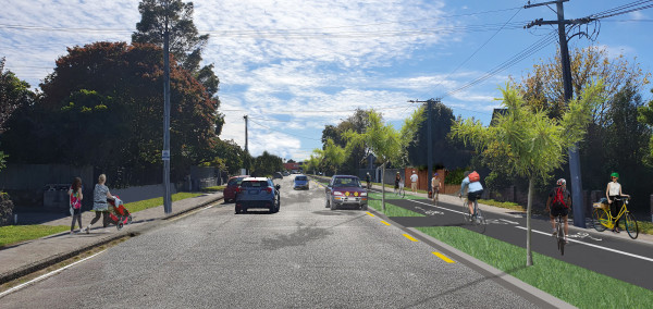
Visualisation of Aorangi Road north of Brookside Terrace with the proposed two-way cycleway on the west side of the road

Visualisation of Matsons Avenue with the proposed two-way cycleway on the east side of the road

Tree removal and replacement

A number of mature trees, predominantly Silver Birch, will need to be removed to make room for the new cycleway. Up to 20 trees will need to be removed along the route, increasing to 39 if the shared path (Option B) is chosen for Aorangi Road.

For each tree removed, two new ones will be planted in the nearest suitable location.

Additional Silver Birch trees along Aorangi Road may need to be removed to protect the power lines. This is not part of the cycleway project and may be undertaken prior to the cycleway work beginning. 

Parking options

We know parking is important to residents and businesses, so we’ve tried to remove as little on-street parking as possible. However, both proposed options have some level of parking loss, as the roads aren’t wide enough to accommodate the cycleway without this.

One-way cycleways (Option A) are considered safer and more intuitive for all users. However, a two-way cycleway on Ilam Road (Option B) will keep more parking. On Aorangi Road, the shared path design (Option B) keeps more parking but removes some trees, which will be replaced where appropriate, further north on Aorangi Road.

Ilam Road

  • Option A (one-way cycleway) - 143 car parks removed (54%)
  • Option B (two-way cycleway) - 123 car parks removed (46%)

Aorangi Road South of Brookside Terrace

  • Option A (two-way cycleway) - 199 car parks removed (46%)
  • Option B (shared path) - 129 car parks removed (30%)

In areas close to schools and shops we are proposing time-restricted parking, to provide easy access to these services.

Aorangi Road North of Brookside Terrace

  • 109 car parks removed (35%)

Safer street lighting

Street lighting will be upgraded where required along the route to make the cycleway safer and easier to use after dark. This will include installing new street lights.

Check the plans for the proposed locations of the new street lights. The lights will be designed by specialists to consider quantity, height, light spill and security.

Slower speeds

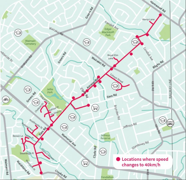
A 40km/h speed limit along the entire route will improve safety for all road users. No exit roads along the route will have a 40km/h speed limit for their entire length (as indicated by the red lines on the map). Narrowing the existing road to make room for the cycleway will encourage lower driving speeds.

40km/h speed limit on cycleway and adjoining roads

Route selection

All route options were assessed against a number of criteria including design context (safety, directness, connectivity, attractiveness, comfort and crime prevention), community and stakeholder impact (business impact, residential impact, operation and network impacts) and other risks (time and cost).

Map showing all routes initially considered

Mop showing all route options that were assessed in detail

The blue route on the map above was preferred as it is an attractive and safe option, with good connections with other activity sites and an uncomplicated and direct route to Northern Line and Wheels and Wings cycleways.

Project objectives assessment for blue (preferred) route

Safety  
High level of safety by significantly minimising exposure to high volume roads, providing signalised crossings of major roads and reducing speeds

Directness
Provides a direct route to Northern Line and Wheels and Wings which matches desire lines and minimal delays.;

Coherence 
Good connection with key trip generators and attractions. Minimises the number of turns and complicated manoeuvres, providing an excellent degree of coherence that will enable easy wayfinding;

Attractiveness 
Provides the opportunity for additional landscaping to enhance the area.

Comfort 
Provides for a high level of comfort by providing separation from both adjacent and crossing traffic.

Crime prevention through environmental design
Provides good surveillance, passing motorists and other road users, well lit, uncomplicated non-hazardous edges.

Business/residential impact 
Acknowledge impact on parking for businesses and residence but to be managed through consultation and mitigated where able

Network impact 
The preferred option will have some maintenance and network impacts including new signalised crossings; however, these will be designed to minimise delays to other modes of transport.

Drop-in sessions

Come and talk to the team about the proposed cycleway.

Please note, these sessions may need to be postponed or cancelled if COVID alert levels change. Under current guidelines, 50 people will be allowed inside the venue at one time and attendees will be kept 2 metres apart. Please scan/sign in and wear a mask.

New Generation Church, 309 Clyde Road (corner Aorangi Road)
Monday 20 September, anytime between 4.30pm and 6pm.

Cobham Intermediate School, 294 Ilam Road
Thursday 23 September, anytime between 3pm and 5.30pm.

Can’t make these meetings?
If there is a community meeting you would like us to attend, please let us know, or phone any time to discuss the project.

Tessa Zant, 03 941 8935, Tessa.Zant@ccc.govt.nz

Share this

Who to contact

Tessa Zant,
Senior Engagement Advisor

How the decision is made

  • Decision made

Takiuru ki ā mātou ratonga
Log in to our services