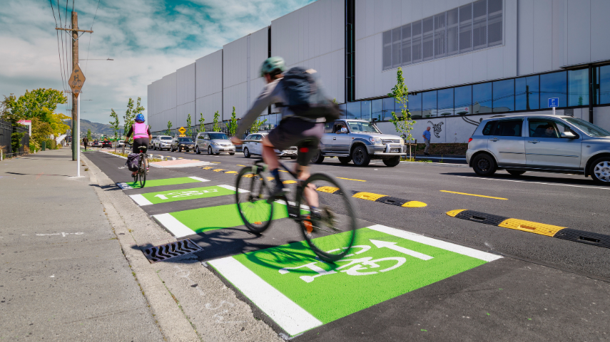
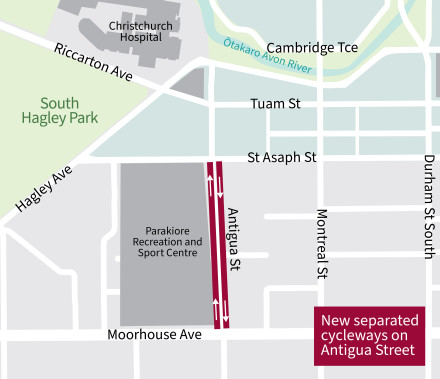
We’ve built a new cycleway on Antigua Street between Moorhouse Avenue and St Asaph Street to improve cycle connections and safety in the central city.

The project also included a watermain renewal to replace pipes which have reached the end of their serviceable life. The new pipes were upgraded to help meet the increasing demands generated by our growing city. Additionally, the road and western footpath were renewed as part of the project.
Work began in May 2025 and was completed in October, ahead of the opening of the new Parakiore Recreation and Sport Centre(external link).
A key cycle connection
Antigua Street is a key cycle connection used by approximately 1000 to 1200 cyclists every day. This is because south of Moorhouse Avenue, Antigua Street is the final stretch for one of our busiest major cycle routes, Quarryman’s Trail, which leads from Halswell.
North of Antigua Street, there is also the Uni-Cycle Major Cycle Route carrying people between Riccarton and the central city via Hagley Park, as well as the east and west central city cycleway networks on St Asaph Street (eastbound) and Tuam Street (westbound).
 The section of Antigua Street – between Moorhouse Avenue and St Asaph Street – sits between these key cycleway routes and directly alongside Parakiore Recreation and Sport Centre, which is due to open late 2025.
The redesigned streetscape, with permanently separated cycleways, will make the road much safer for people who travel by bike, whether for work, school, shopping, or recreation.
Map of the nearby cycleway connections. [JPG, 387 KB]
To explore all the cycle connections in the city, view the Christchurch Bike Map.(external link)
The design of the street upgrade focuses on safety and accessibility for all users along Antigua Street, including cyclists, pedestrians, local businesses and the Parakiore facility.
We will also be enhancing the area with new street trees and landscaping.
The key features of the design include:
- A 2.4m wide northbound separated cycleway on the west side of the road (beside the northbound lane which runs alongside Parakiore). To retain the maximum road space, we’ve utilised some Parakiore land for this cycle lane.
- A 2.3m wide southbound separated cycleway on the east side of Antigua Street. This transitions to a 2.2m wide cycle lane south of Moorhouse Avenue.
- A pedestrian and cycle crossing point in the middle of the block, near the entrance to Parakiore and just south of Halkett Street.
- Two raised speed thresholds (outside 184 Antigua Street and 230b Antigua Street) to encourage motorists to travel at a safe speed. The road has been operating at 30km/h since the construction of Parakiore started, and will remain at 30km/h during construction. Following the works, the speed will become 50km/h again; however, it is anticipated that, given the design of the road, the actual operating speed will be closer to 30km/h.
- On-street parking on the west side of Antigua Street only. All parking on the east side will be removed to allow enough space for the new separated cycleway and to provide clearer sightlines from driveways, making a safer environment for cyclists and pedestrians.
- Renewed and widened footpath on the west side of Antigua Street to accommodate the expected increased pedestrian use, driven by Parakiore Recreation and Sport Centre. The footpath will run adjacent to the northbound cycle lane.
- New landscaping along Antigua Street which includes new rain gardens and street trees.
- Installation of two P10 parking spaces on Halkett Street outside Antigua Food Bar to assist with customers who require short-term convenience parking when visiting businesses along Antigua Street.
This project was consulted on between 15 February and 15 March 2022. The consultation included proposed improvements to the Antigua Street footbridge, which are also being constructed in 2025 as a separate project, between early June and early July.
The Antigua Street cycle connection received 117 submissions, and the Antigua Street footbridge received 95 submissions.
The majority of submitters commented on both projects, with a small number commenting on just one.
See the details of the consultation(external link).
Decision
A hearing was held on Monday 11 April 2022. You can read the meeting agenda and minutes(external link).
The Hearings Panel recommendation was approved by Council on 12 May 2022. Read the minutes(external link).
In 2022, we consulted with the community on the Antigua Street cycleway connection. As part of this project, we proposed lowering the speed limit to 30km/h on Antigua Street between Moorhouse Avenue and St Asaph Street. The Council approved this design, including the speed limit change in May 2022.
Last year, the government introduced their new Land Transport Rule - Setting of Speed Limits(external link). This legislation states that we can't install any previously approved speed changes that are not yet in effect.
In August this year, the Council voted to consult the community on these speed limit changes before making a decision under the new Setting of Speed Limits rule.
The Council originally approved 30km/h speed limits on Antigua Street. However, under the new Rule, 30km/h is not allowed on urban streets, so we're proposing to change the speed to 40km/h to make it safer for people walking and cycling on this street. Parakiore Metro Sports Centre will be opening soon and will increase the people travelling around here. We want everyone to get where they are going safely, regardless of how they are travelling.
Consultation on Antigua Street speed limit changes has now closed(external link). People were able to provide feedback from 19 September to 31 October 2025. You will be able to read their feedback and the staff recommendation once an agenda is available for the Council meeting, which we expect to be in December 2025.
