Christchurch’s major cycleways network is designed to be a safe and convenient option to get people on bikes to where they want to go. Ten of the 13 planned cycleways are now open for you to ride.
Get the latest on cycling news and events in Ōtautahi Christchurch.

Getting more people cycling is key to addressing climate change, creating healthier communities and reducing congestion.
Find out what the cycleways look like and learn how to use them.

Puari ki Pū-taringa-motu cycleway connects Ilam and the University of Canterbury to the Central City, via Mona Vale, Pūtaringamotu / Riccarton Bush and North Hagley Park.
You can ride this scenic, tree-lined cycleway to Mona Vale’s beautiful grounds and high tea on the weekends, or to the Riccarton Bush Saturday farmers’ market.
On your way into the city, you will ride through North Hagley Park before arriving at the Canterbury Museum and Arts Centre on Worcester Boulevard.
This cycleway links to Nor’West Arc cycleway at the University of Canterbury and the Northern Line cycleway at the rail crossing near Mona Vale.
Uni–Cycle was named Supreme Winner(external link) at the 2018 national Bike to the Future Awards.

Puari ki Wairewa cycleway connects Wigram, Sockburn, Middleton and Addington to the Central City, and connects with the Little River Rail trail for those wanting a recreational ride further afield.
The cycleway runs from Wigram alongside the Southern Motorway, through Addington’s residential streets and Church Square, and through South Hagley Park to Central City.
The Christchurch end of the route is great for anyone looking to get active as it runs through Hagley Park and links to the Ngā Puna Wai Sports Hub. You will also glide through the historic Church Square in Addington.
The cycleway connects at Marshs Road with the Little River Rail Trail which starts as a shared path and goes all the way to the Little River township via Prebbleton and Lincoln.
If you’d like to cycle the Little River Rail Trail, see their website littlerivertrail.kiwi.nz(external link).

Puari ki Papanui cycleway connects the Northern Line Cycleway, Northlands Mall, Papanui and St Albans to the Central City.
This is a good route to head to the pool or for a workout at the Graham Condon Recreation and Sport Centre, and you can also get your retail fix at Northlands Shopping Centre or Edgeware Village.
It connects to the Northern Line cycleway at Sawyers Arms Road and links at Rutland Reserve to the shared path that runs along the Christchurch Northern Corridor all the way to Kaiapoi in the Waimakariri District.

Puari ki Otūmatua major cycle route connects Halswell to the Central City via Hoon Hay, Spreydon and Somerfield.
The route starts at Te Hāpua: Halswell Centre and Halswell Domain and provides a safe route to four schools in the Hoon Hay area. It also connects recreation facilities Pioneer Stadium in Hoon Hay and the Parakiore Recreation and Sport Centre Sports that is currently being built on Antigua Street in Central City.
It connects to the Nor'West Arc major cycleway at Centennial Park and will link to the Southern Lights cycleway on Strickland Street once this is built.
Te Ara O-Rakipaoa cycleway connects Princess Margaret Hospital to Bryndwr, via Spreydon, Middleton, Riccarton and Ilam.
You can ride from Princess Margaret Hospital to Pioneer or Jellie Park Sports and Recreation Centres for a swim or workout. You can travel safely to seven schools along the route, and to the University of Canterbury.
The cycleway connects with the Quarryman’s Trail cycleway at Sparks Road, Little River Link at Wigram Road, South Express at Suva Street, and Uni–Cycle at Ilam Fields.
The sections of the Nor’West Arc between Cashmere Road and Wigram Road, and from Hansons Lane past the University to Jellie Park are complete.
In future, the final section of this cycleway from Jellie Park to Harewood Road will run along Ilam Road to Aorangi Road, past the Wairakei shops, and along Condell Avenue and Matsons Avenue before linking to the Northern Line cycleway near St James Park at Harewood Road. Construction of this final section is expected to start in late 2024.
Puari ki Pū-harakeke-nui Northern Line cycleway connects Northwood, Northcote, Casebrook and Papanui to Riccarton and Hagley Park with a shared path that runs alongside the Northern Line railway corridor.
Central City is also easy to get to from the Northern Line cycleway via the connection to the Papanui Parallel cycleway at Papanui Domain on Sawyers Arms Road. University students can link onto the Uni–Cycle cycleway at the southern end and head west to the University of Canterbury.
Along the Northern Line cycleway route, you can ride to Graham Condon Recreation and Sports Centre for a workout or a swim, or visit Northlands Mall for some shopping. You can also travel safely to a number of schools, including Papanui High School, Heaton Normal Intermediate School and Te Kura o Matarangi Northcote School.
St James Park is a great place to check out monarch butterflies or continue south for a stroll around Mona Vale Homestead and Gardens or Hagley Park.
Puari ki Rapanui cycleway connects Sumner via the Christchurch Coastal Pathway to Central City, passing through Linwood.
The Christchurch Coastal Pathway(external link), a path shared with people walking, is now open, running from Sumner to Rapanui Shag Rock, and through Redcliffs to Ferrymead Bridge. Here it connects seamlessly with the Rapanui – Shag Rock major cycle route, which continues through Charlesworth Reserve to Linwood Avenue, then through Linwood Park and quiet residential streets to the intersection of Fitzgerald Avenue and Worcester Street.
On your way to the city, the cycle route takes you through Charlesworth Reserve which is a tidal wetland home to native birds and over 100,000 trees and shrubs, and through the daffodils on Linwood Avenue.
You can ride to Te Pou Toetoe Linwood Pool for a swim, visit Eastgate Mall and Stanmore Road for some shopping, or get yourself safely to Linwood Avenue School.
Railway crossing safety upgrade at Scruttons Road
The Heathcote Expressway cycleway will remain open for now.
KiwiRail has agreed to the Council pausing the closure of the 1.5km section of the Puari ki Kahukura Heathcote Expressway between Vaila Place and Truscotts Road. How long the cycleway will remain open for is yet to be confirmed.
Puari ki Kahukura cycleway connects Heathcote with the Central City via Woolston and Waltham.
From the city, you can ride down Ferry Road past Ara Institute’s Madras St campus, and around to Lancaster Park. Ara Institute’s Woolston campus is next on the route, connecting students from the city or the southeast suburbs to their place of study.
Continuing southeast, you'll cross the Ōpāwaho Heathcote River and follow the awa, reaching a lovely stopover at The Tannery, which offers a boutique shopping experience and cinema.
From there, you'll continue winding your way alongside the Ōpāwaho Heathcote River, then safely cycling alongside arterial roads and railways before reaching Ferrymead Heritage Park. The cycleway ends at Martindales Road in Heathcote Valley.

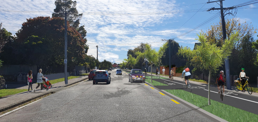
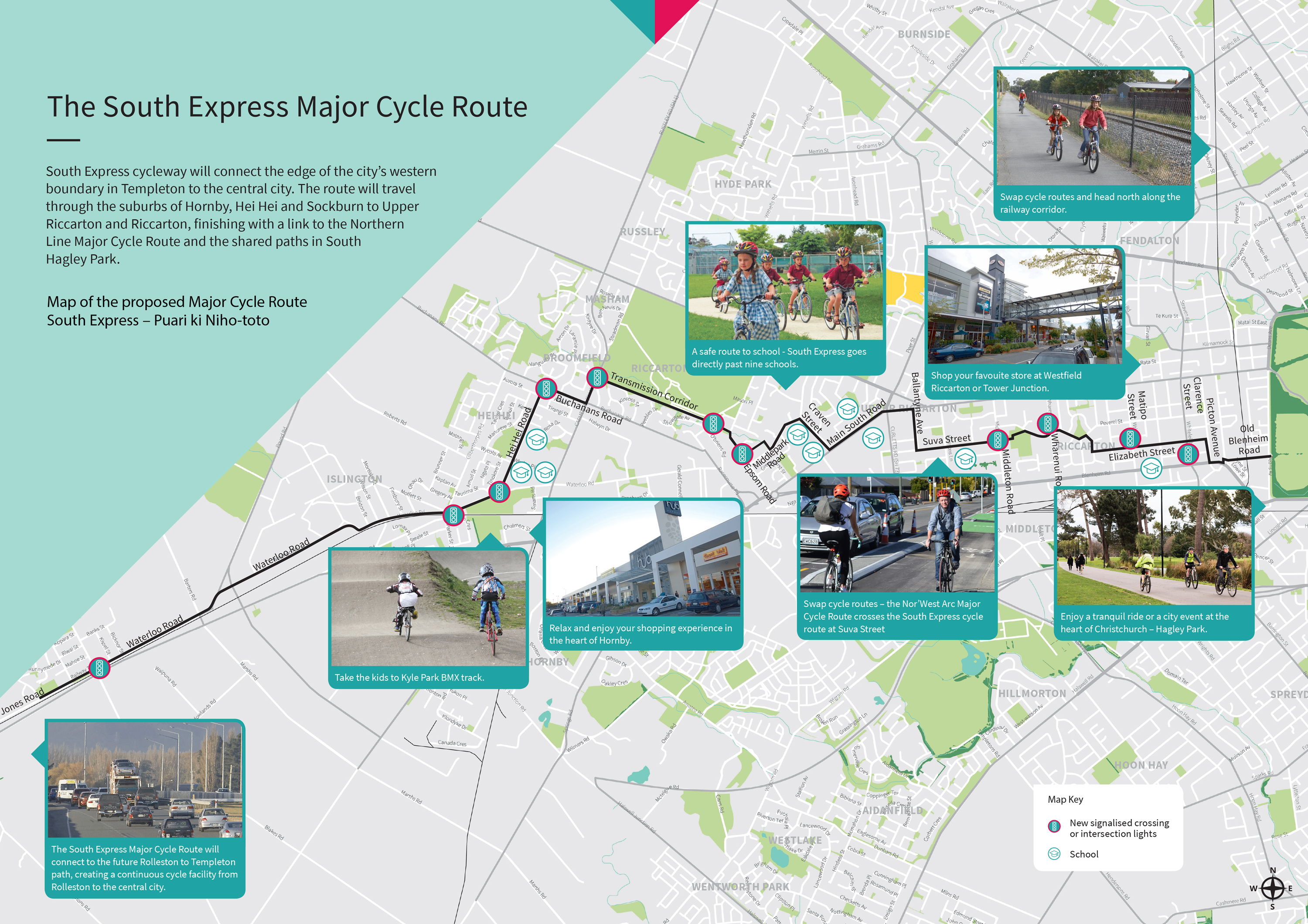
Puari ki Niho-toto South Express cycleway currently connects Kyle Park in the west to Central City, via Hei Hei, Riccarton Park, Upper Riccarton and Riccarton.
You can travel safely to nine schools along the entire route, access The Hub Hornby shopping centre via Kyle Park, or visit Matatiki Hornby Centre’s library, pool, and rec and sports centre.
On a Sunday, you can ride straight to the Riccarton Market. From Upper Riccarton Library, you can visit Wharenui Recreation Centre, and there are more shopping options at Westfield Mall before arriving in the Central City via South Hagley Park.
South Express also connects with the Nor’West Arc cycleway at Middleton Road to take you to the University of Canterbury, and the Northern Line near Old Blenheim Road towards Papanui.
Once the full cycleway is completed, it will reach Templeton, joining up with the Selwyn District Council’s cycleway on Jones Road to provide a safe link through to Rolleston.
Progress so far
Puari ki Niho-toto South Express cycleway is open from the city to Kyle Park, creating an uninterrupted 10km route from the central city through Riccarton and out to Hornby.
Construction is underway to extend the cycleway west along Waterloo Road from Barters Road to Jones Road, where it will join up with Selwyn District Council’s cycleway to Rolleston. Our project webpage has more details.
The final section to be completed includes the Gilberthorpes Road/Waterloo Road/Parker Street/Moffett Street intersection, and a stretch of Waterloo Road from the western end of Kyle Park to Finsbury Street. This work is dependent on collaboration with KiwiRail.
Download the original route map [JPG, 3.1 MB]
Download the detailed route plans [PDF, 19 MB]
Read the Newsline story(external link)
See the Christchurch bike map [PDF, 3.1 MB]
Visit the Wheels to Wings page(external link) for more information about the Wheels to Wings Papanui ki Waiwhetū cycleway.
Once built, Puari ki Waimōkihi cycleway will connect the southern suburbs around Beckenham to Central City.
You will be able to ride from the Ōpāwaho Heathcote River on Tennyson Street to the Beckenham shops for a bite to eat, and into town on the Quarryman’s Trail.
In the future, this cycleway will also connect to the Ōpāwaho River Route cycleway, once this is built.
Once built, Puari ki Te Karoro cycleway will connect New Brighton to the Central City.
A natural extension of the Central City river pathway, it will primarily provide a high-quality route for recreation and tourists and, in sections, commuter cycling.
You will be able to visit New Brighton Beach, the Pier and He Puna Taimoana Hot Pools and do a bit of shopping or grab a bite to eat in the New Brighton mall area.
Once built, Ōpāwaho ki Ihutai cycleway will connect Ōpāwaho Heathcote River near Princess Margaret Hospital to the estuary at Ferrymead.
This major cycle route will run alongside the river as it meanders through the southern suburbs via Cashmere High School, South Library and Hansen Park. This scenic route will connect the Nor’West Arc, Southern Lights and Heathcote Expressway cycleways, as well as the well-used mountain bike tracks at Mt Vernon Farm, Rāpaki, and Huntsbury.
The exact route for this cycleway has not been decided but is likely to be a mixture of on-road greenways, shared paths and dedicated cycleways along the Ōpāwaho Heathcote River.
Visit the City to Sea Pathway project page(external link) for more information about the partially complete City to Sea shared path.
Related news
Transport and water upgrades planned for Lincoln Road
A major upgrade to Lincoln Road starts in April, installing peak hour bus lanes and improving water and wastewater services.
12 Feb 2026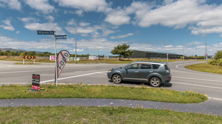
Upgrade for busy intersection in city’s south-west
New traffic signals at the intersection of Wigram and Hayton roads will help meet the needs of a growing community and new facilities in the area.
9 Feb 2026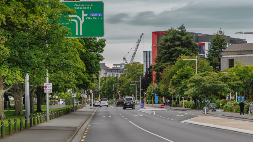
Feedback sought on clearway trial
Christchurch City Council is asking for feedback on the clearway being trialled on Hagley Avenue.
30 Jan 2026