Wheels to Wings – Papanui ki Waiwhetū Major Cycleway

We’re seeking your views on plans for improved cycling facilities as part of the Wheels to Wings – Papanui ki Waiwhetū Major Cycleway.

Project status: Hearing
Open for feedback: 25 January 2021 to 15 March 2021

Share this

Consultation has now closed

Consultation on Wheels to Wings - Papanui ki Waiwhetū Major Cycleway has now closed. People were able to provide feedback from 25 January 2021 to 8 March 2021.  A second round of engagement was held from 27 October 2021 to 17 November 2021 seeking further feedback on changes made to the design following the first consultation.

During both consultations we heard from 1434 individuals and groups. You can read their feedback in the July 2021 update below and also find out how this influenced the Hearings Panel recommendation(external link).


October 2021 update

We're holding three community information days to share with you what we heard during the consultation, our responses, the changes based on your feedback and further information on the proposed cycleway (including other options we've looked at). You are able to book your spot at one of these sessions and view new updates here(external link).


August 2021 update

We’re postponing the Wheels to Wings – Papanui ki Waiwhetū cycleway information days due to Covid-19 restrictions. We apologise for the inconvenience and we’ll look to reschedule as soon as possible.

We were planning to hold the information days on Thursday 2 and Friday 3 September.

It’s really important that we have a conversation with the community about the changes we’ve made and the different design concepts looked at, so we’re waiting until we can have these discussions in person.

As there has been a high level of engagement with this project it is important that we have the information days when people feel comfortable attending and have the time to consider the information. There will still be an opportunity to give further feedback as planned on the additional design work we’ve done when we hold the information days at a later date.

The other meetings to be rescheduled are:

  • a briefing for the hearings panel;
  • a community board workshop; and
  • a hearing to consider oral submissions and make a recommendation to the Urban Development and Transport Committee.

July 2021 update

Consultation on Wheels to Wings – Papanui ki Waiwhetū Major Cycleway has now closed. People were able to provide feedback from 25 January to 15 March.

During this time we heard from 1348 submissions from individuals and groups. Many submitters have lived, or worked, in the area for a long time and have provided us with very detailed feedback. Thanks again for taking the time to consider the cycleway proposal. [insert number of responses]  You can read their feedback below.

Themes of the feedback

Submitters who support the cycleway identified better safety for people biking, a safe route for children to get to school and the positive impact on climate change as their key considerations. 

Submitters who don’t support the cycleway identified loss of parking, increased traffic congestion as a result of reducing four lanes to two and the cost of the project as their key issues.

Other issues raised by those not in support include:

  • Safety – property access, driver behaviour and cycleway design
  • Safety concerns at Harewood/Greers intersection
  • Bishopdale roundabout – design of the roundabout and trees
  •  Access for emergency services
  • Bus stop changes
  • How the wider network will function (including Langdons Road)
  • Alternative route suggestions and design options

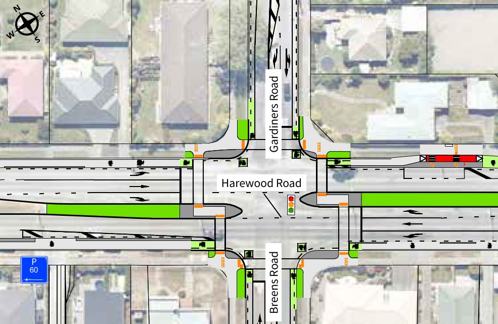
There was widespread support for signalising the Harewood/Gardiners/Breens intersection.

Submissions

Business and organisations submissions(external link)

Individual submissions(external link)

Attachments to submissions (external link)


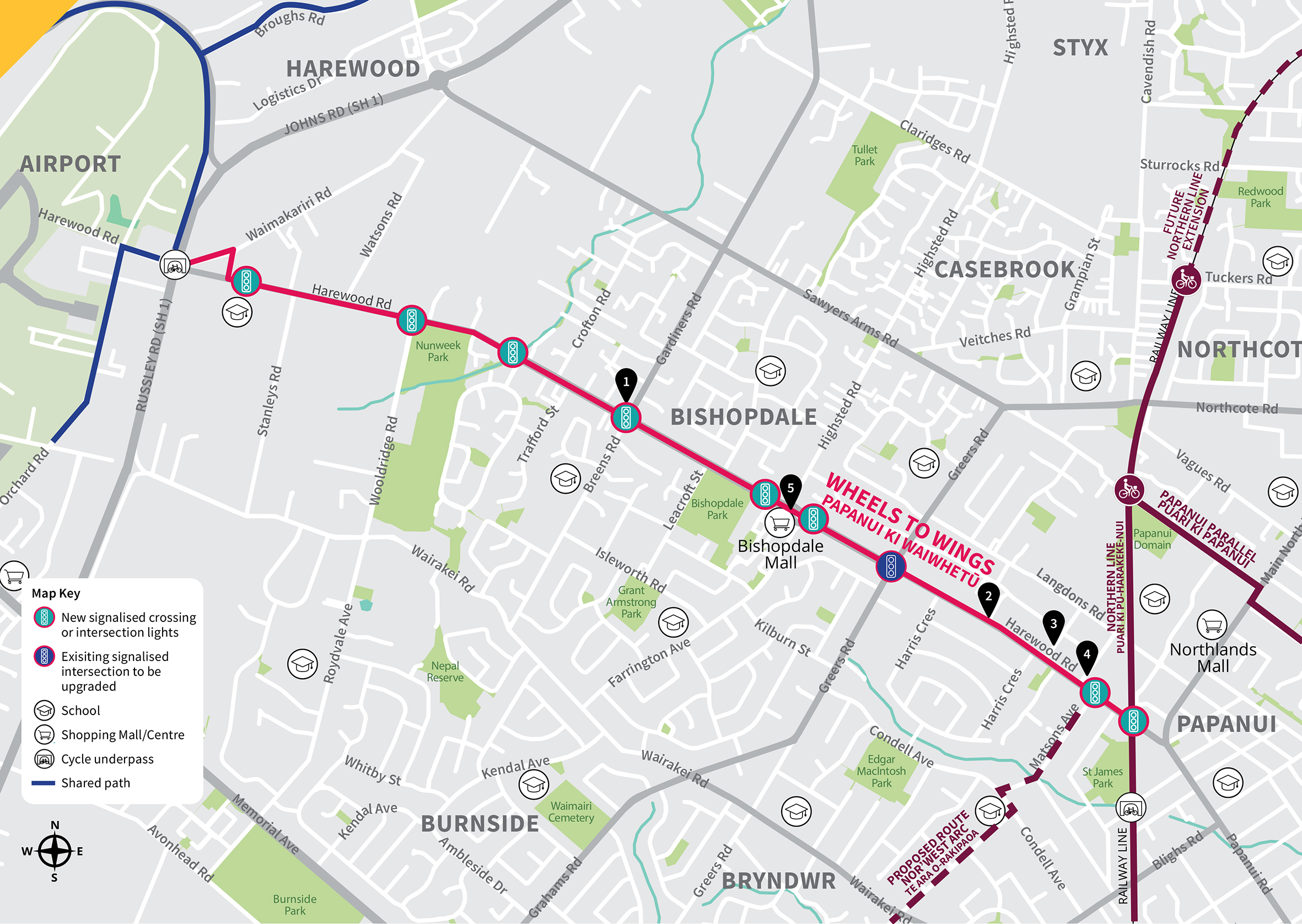
Wheels to Wings – Papanui ki Waiwhetū will provide a connection for local cycling trips in the Harewood, Bishopdale and Papanui suburbs to destinations including schools, shops, businesses and recreational facilities. It will also connect to cycling facilities further afield.

At its western end, Wheels to Wings – Papanui ki Waiwhetū will connect with the Johns Road cycle and pedestrian underpass, linking through to the commercial areas surrounding the airport, and to McLeans Island Road via the Johns Road shared path. This will be a good connection route for the large number of people working in the commercial area near the airport.

At its eastern end, Wheels to Wings Papanui ki Waiwhetū connects directly to the Northern Line cycle route and the future Nor’West Arc cycleway which is currently planned along Matsons Avenue (this will be consulted on later in the year).

Consulted option details

The Wheels to Wings – Papanui ki Waiwhetū route can be divided into the following six sections:

  1. Whitchurch Place, Waimakariri Road, and Harewood Road up to Nunweek Boulevard Widening of the existing shared paths and construction of a  two-way separated cycleway between Kilmuir Lane and Nunweek Boulevard, along with improved road crossings and intersections.
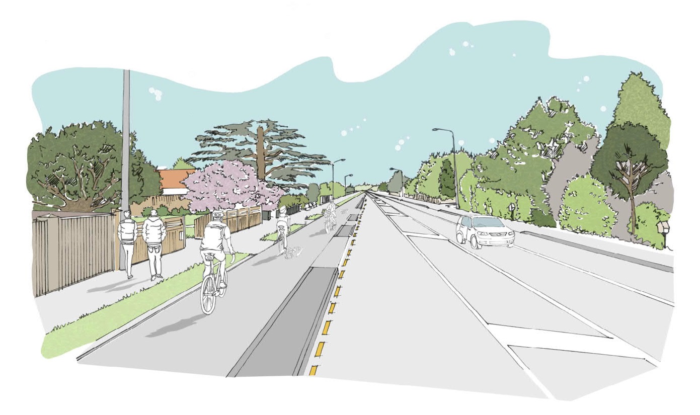
  2. Harewood Road from Nunweek Boulevard to the Bishopdale  Roundabout One-way separated cycleways on each side of the road. This will require the removal of one traffic lane in each direction along the four-lane section of Harewood Road and the removal of some on- street parking.
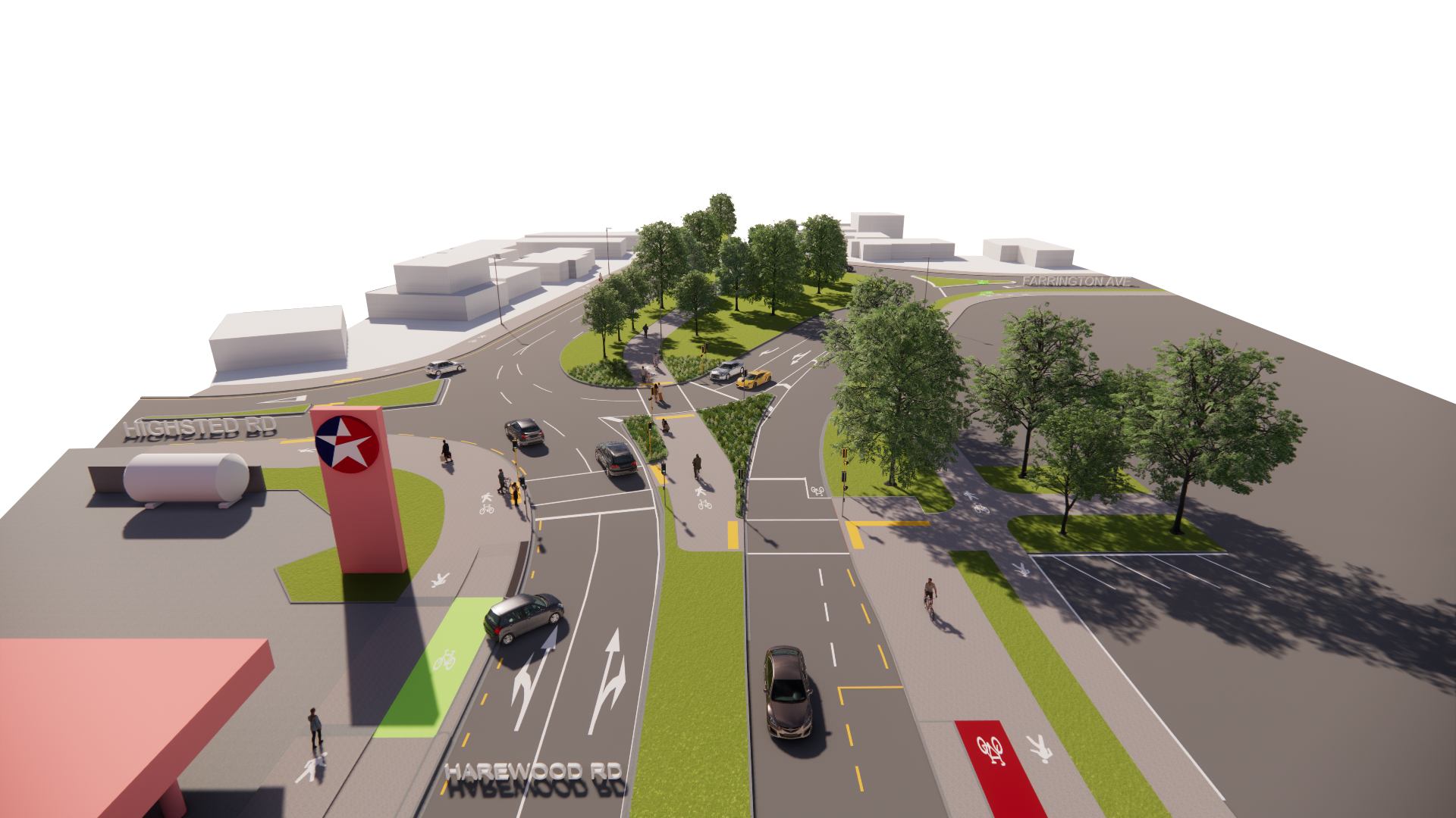
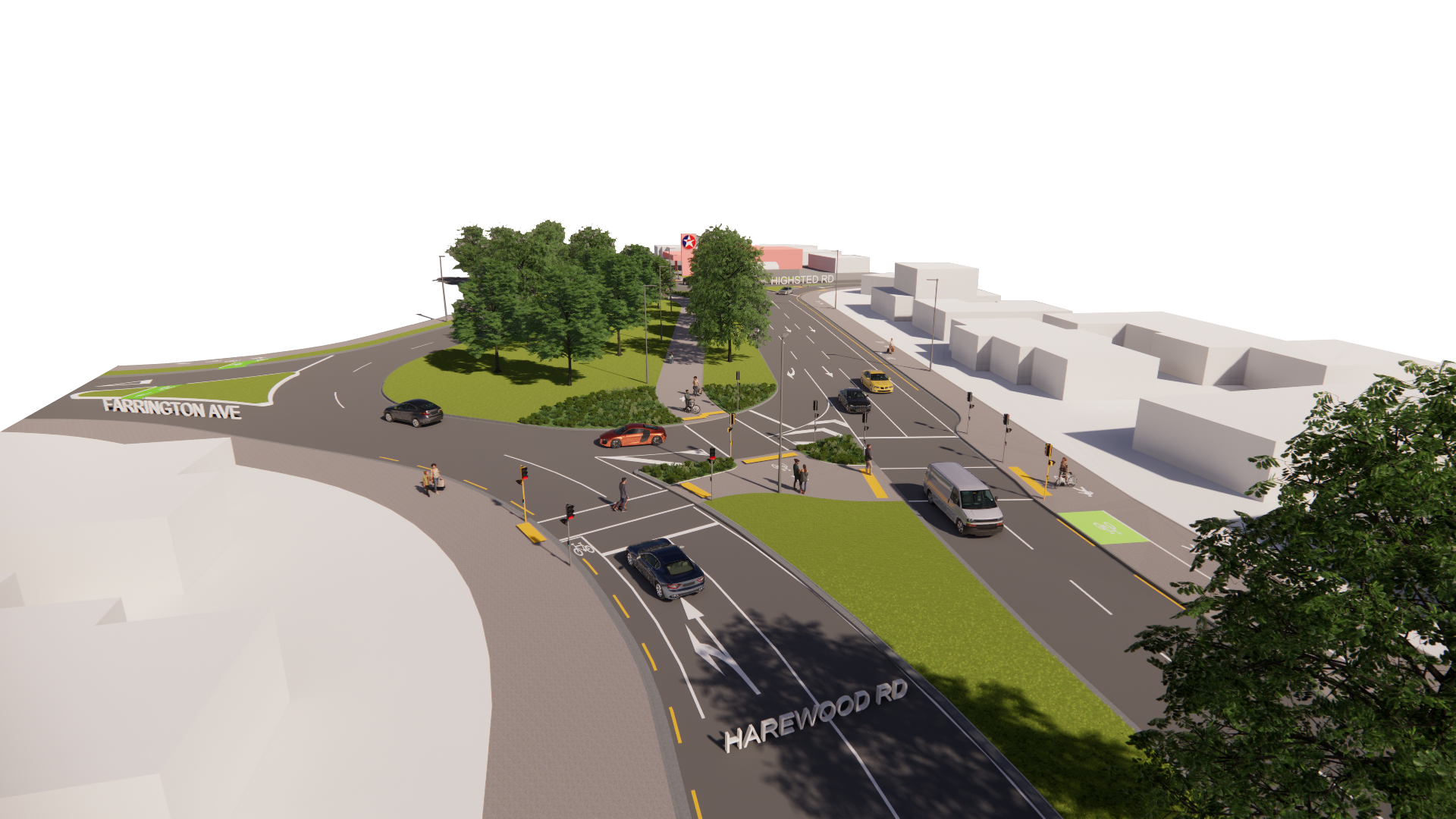
  3. Bishopdale Roundabout New traffic signals at the east and west ends of the Bishopdale Roundabout will provide crossings for people cycling and walking through the roundabout and across Harewood Road, as well as controlling vehicles coming into the roundabout from Harewood Road.
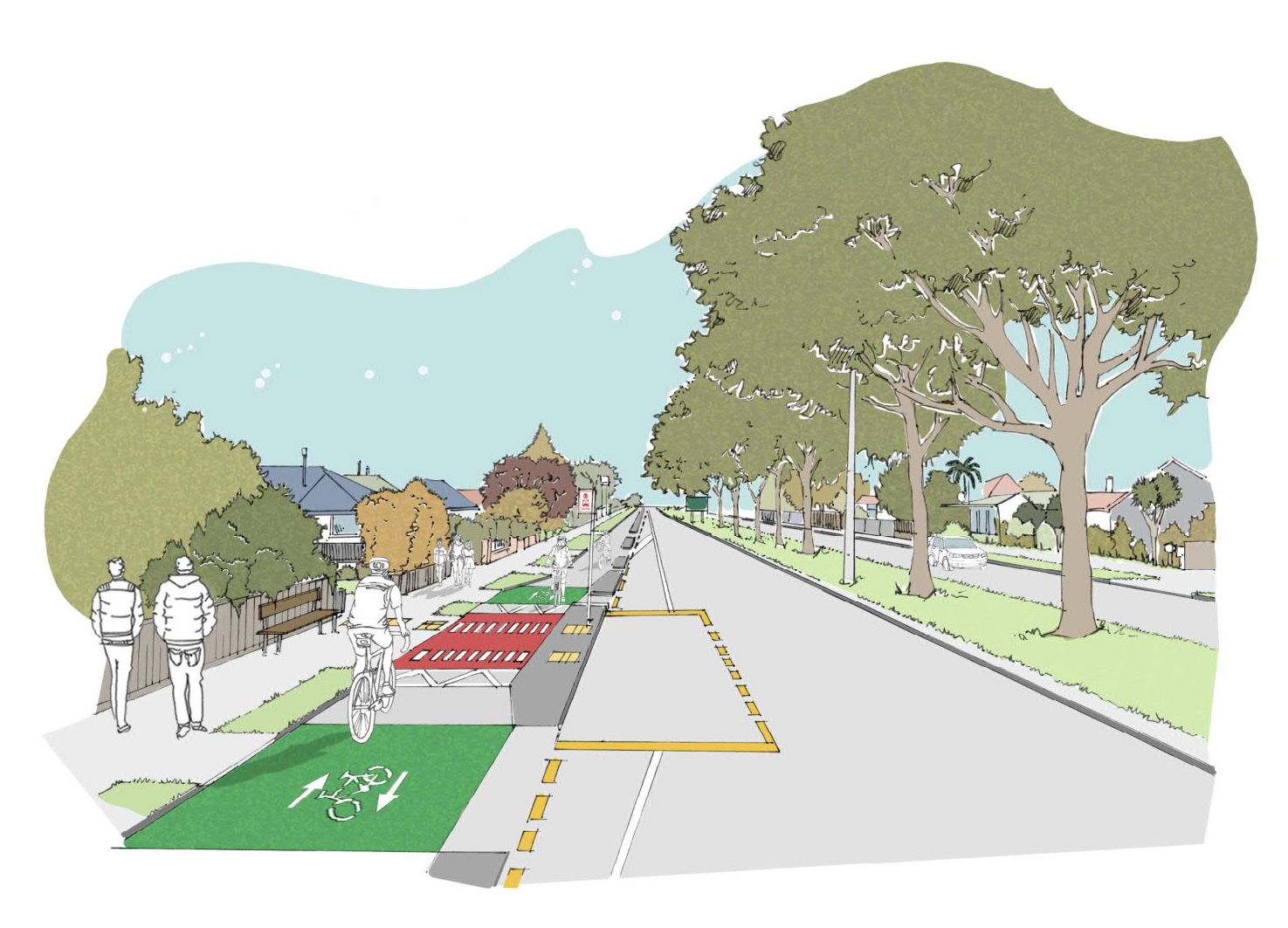
  4. Harewood Road from the Bishopdale Roundabout to Greers Road A two-way separated cycleway is proposed on the northern side of Harewood Road. This will require the removal of adjacent on- street parking and one traffic lane. Additional on-street parking will be provided on the southern side of the central median.
  5. Harewood Road from Greers Road to Matsons Avenue A two-way separated cycleway is proposed on the northern side of Harewood Road, removing the adjacent on-street parking. Some restrictions to vehicle access at side roads are proposed.
  6. Harewood Road from Matsons Avenue to Northern Line One-way separated cycleways are proposed on each side of Harewood Road. This will result in the removal of on-street parking on both sides of the road.

  Key changes:
  • Harewood Road reduced from four lanes to two lanes.
  • New traffic signals at Harewood/Gardiners/Breens intersection and Wooldridge/HarewoodRoad intersection.
  • Traffic signals at each end of the Bishopdaleroundabout.
  • New signalised crossings at HarewoodPrimary School, Nunweek Boulevard, and Harewood Road near Matsons Avenue.
  • Changes to vehicle access on Wilmot Street, Sails Street and Chapel Street at Harewood Road.

Route maps

Map 1 Waimakariri Road end of Harewood Road [PDF, 11 MB]

Map 2  mid section of Harewood Road [PDF, 10 MB]

Map 3  east end of Harewood Road [PDF, 8.5 MB]

Changes to road layouts

Changes to road layouts along the route have been proposed to improve safety for everyone. These changes include new signalised intersections and crossings, and safety improvements to existing intersections.

The four-lane section of Harewood Road is proposed to be reduced to two lanes to make space for cycling and on-street parking. This will also encourage lower speeds and make the road safer for turning drivers and pedestrians to cross. There will be additional lanes at some
intersections to maintain the traffic capacity along Harewood Road.

We’re signalising the Harewood/Wooldridge and Harewood/Gardiners/Breens intersections, partially signalising the Bishopdale roundabout and upgrading the Greers/Harewood intersection. These changes allow for the cycleway and help to improve safety overall.

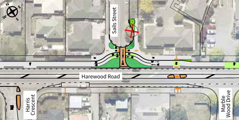
We’re proposing to cul-de-sac Wilmot Street at Harewood Road, make Sails Street exit only onto Harewood Road and make Chapel Street entry only from Harewood Road. This will improve safety by reducing the amount of traffic turning across the cycleway.

A new signalised crossing outside Harewood Primary School and an extension to the school speed zone are proposed to improve school access.

Parking

We have tried to minimise the removal of on-street parking, however the competing demands for road space mean that some on-street parking will be removed along the route.

The design proposed was chosen to minimise the loss of on-street parking while maintaining safety for people cycling.

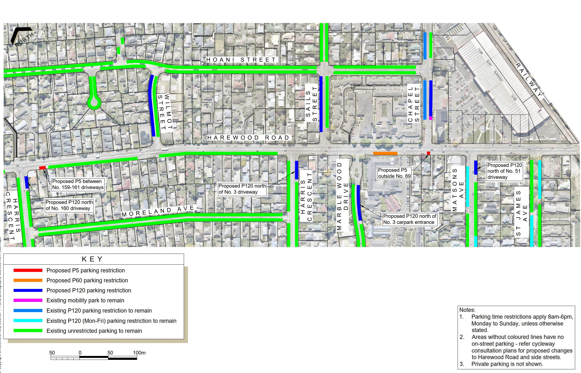
In areas of high parking demand we are proposing time-restricted parking on Harewood Road and nearby side streets to help ensure convenient parking is available.

Street lighting

Street lighting will be upgraded along the route to make the cycleway safer and more comfortable to use after dark. This will include the installation of new street lights where the current lighting levels do not meet the requirements for a cycleway or other changes to the road. This will require some new street lights to be installed, at locations to be confirmed in future stages of the project as the design progresses.

Trees

A total of 21 trees are proposed to be removed as part of this project in order to provide space for the cycleway and traffic lanes, improve visibility, and where the trees may pose a risk to people walking or cycling. A total of 56 new trees are proposed to be planted along the route, as shown in the detailed plans, however these are subject to confirming underground services at these locations.

The eucalyptus and oak trees in the Bishopdale Roundabout are proposed to be removed. A shared path is proposed within the roundabout island, and the eucalyptus trees can pose a risk to path users from falling branches. The risk of this is increased due to the removal of several adjacent trees to fit the new path and turning traffic lanes. The remaining oak trees need to be removed as they are interdependent on the surrounding trees, leaving them at risk of becoming unstable as other trees are removed.

Replacement trees are proposed in the roundabout, which include exotic species alongside the path to provide fast-growing shelter, with natives in other parts of the roundabout.

Detailed plans

Plans are below the table

Plan number

Features
1

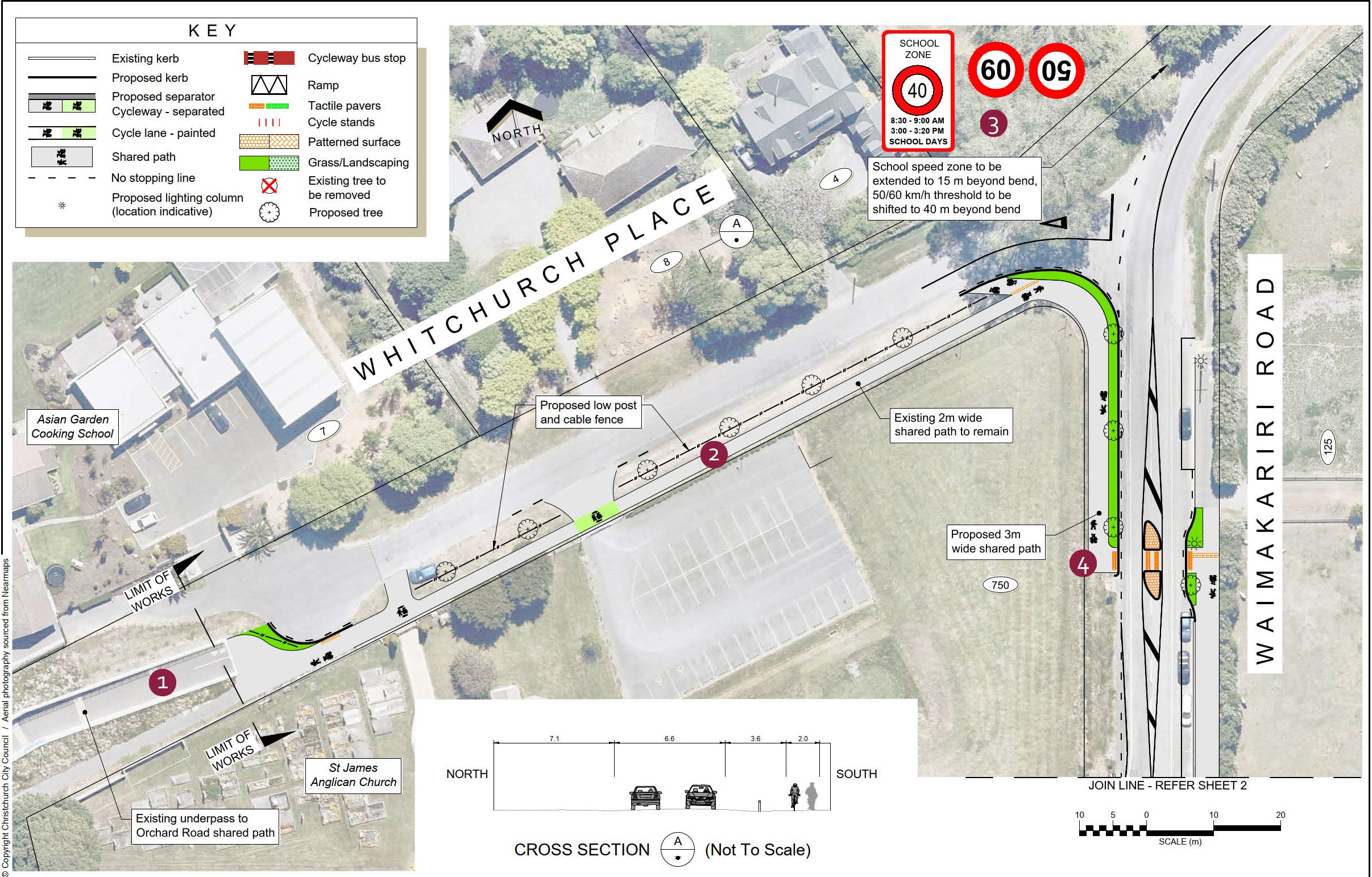
Whitchurch Place and Waimakariri Road

  1. The existing underpass under Johns Road connects to the Orchard Road and McLeans Island Road shared paths. The access into the underpass from Whitchurch Place will be realigned to make it easier to negotiate by bike.
  2. The existing 2m wide shared path along Whitchurch Place is retained, with access onto the road provided at each end to enable people to also cycle on the road through this section.
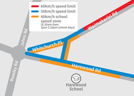
  3. The existing 50 km/h speed limit and 40 km/h school speed zone are extended to beyond the bend on Waimakariri Road, including Whitchurch Place.
  4. A new 3m wide shared path along the western side of Waimakariri Road connects to the existing shared path on the eastern side via a new 2.5m wide refuge island.

Street lighting will be upgraded to make the path safer and more comfortable for use after dark. This will include the installation of new street lights at locations to be confirmed in future stages of the project.
2

Harewood Road - 750 to 714

  1. The refuge island and school crossing outside Harewood School is replaced with a new signalised cycle and pedestrian crossing on a raised safety platform.
  2. The path on the south side of Harewood Road is widened to create a 4m wide shared path past Harewood School and Playcentre.
  3. The existing narrow path on the south side of Harewood Road is widened to create a 3m wide shared path.

Raised safety platforms are being used increasingly to manage vehicle speeds at intersections and crossings on arterial roads in New Zealand and overseas.  The raised safety platforms proposed for use on Harewood Road are different to the steeper platforms used for traffic calming on local roads, in this case being designed for a maximum comfortable speed of 40 km/h.
3

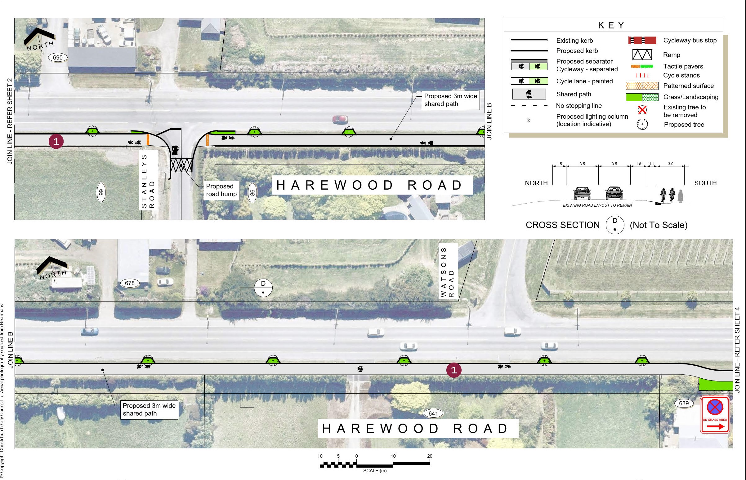
Harewood Road - 690 to Watsons Road

  1. The existing narrow path on the south side of Harewood Road is widened to create a 3m wide shared path.
4

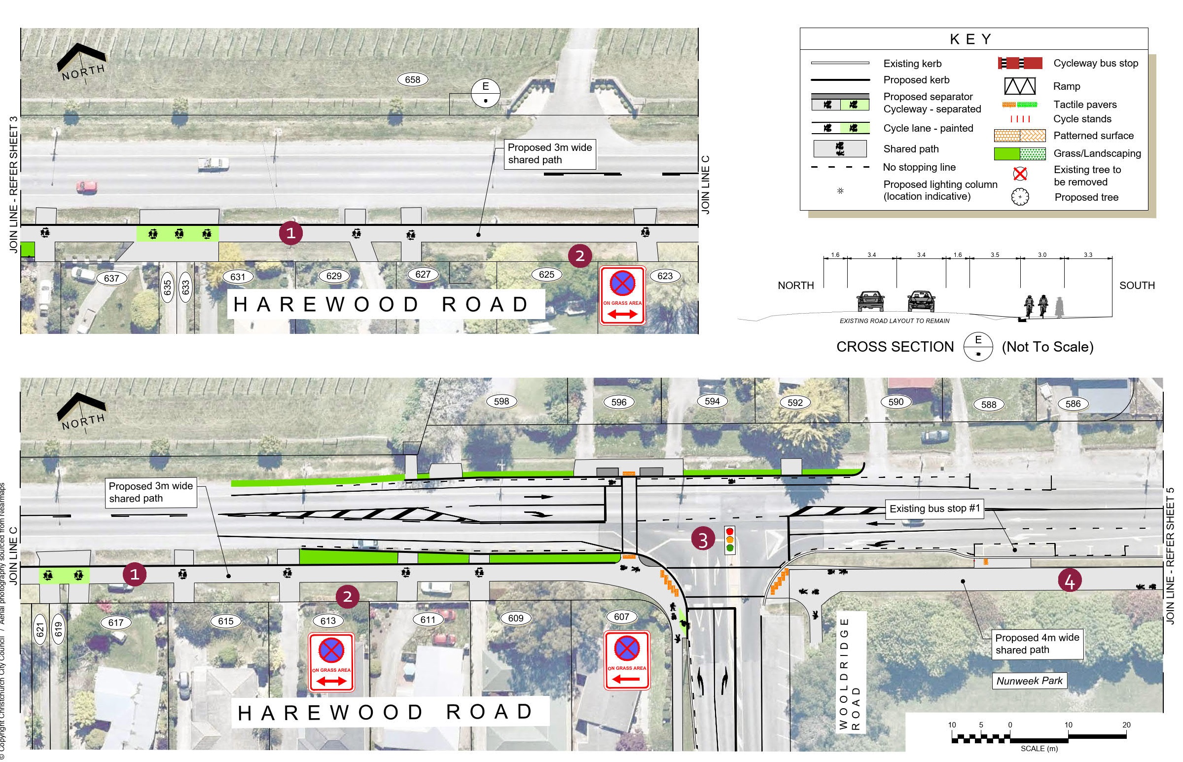
Harewood Road - 658 to 586

  1. The existing narrow path on the south side of Harewood Road is widened to create a 3m wide shared path.
  2. Parking on the grass berm is prohibited so that drivers exiting driveways have unrestricted visibility of people cycling along the path.  Parking on the sealed shoulder is still permitted at locations without ‘no stopping’ markings.
  3. New traffic signals at Wooldridge Road make the crossings safer for people walking and cycling and make it easier for drivers to turn out of Wooldridge Road.
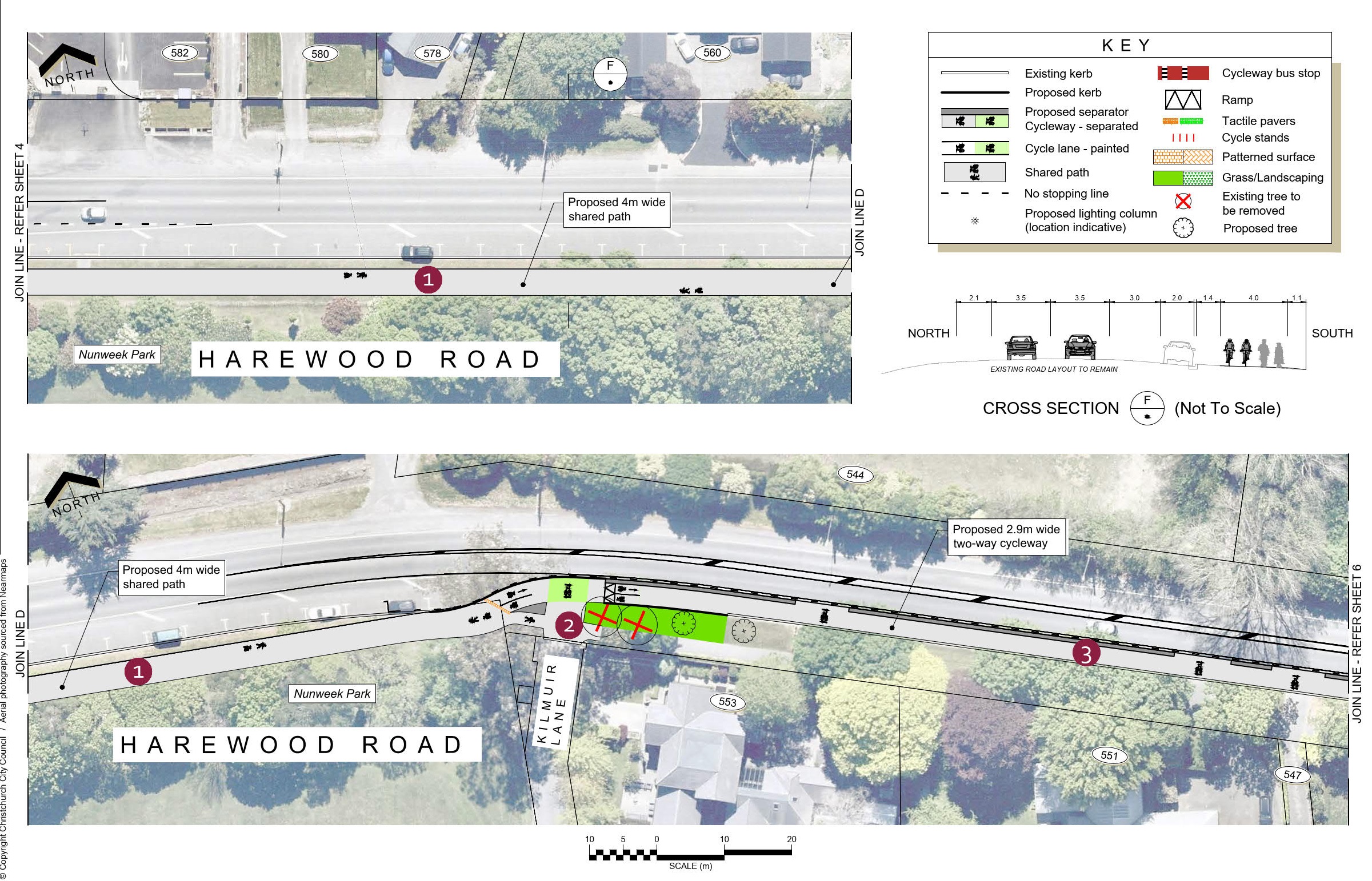
  4. The path outside Nunweek Park is widened to create a 4m wide shared path.
5

Harewood Road - Nunweek Park to 547

  1. The path outside Nunweek Park is widened to create a 4m wide shared path.
  2. Two trees east of Kilmuir Lane are removed to improve driver visibility of approaching cyclists.  Two replacement trees are planted nearby.
  3. At Kilmuir Lane, the cycleway transitions to a two-way separated cycleway on the south side of the road.  This avoids affecting the mature trees in this area, while also avoiding safety issues with people cycling close to property fences at driveways.
 6

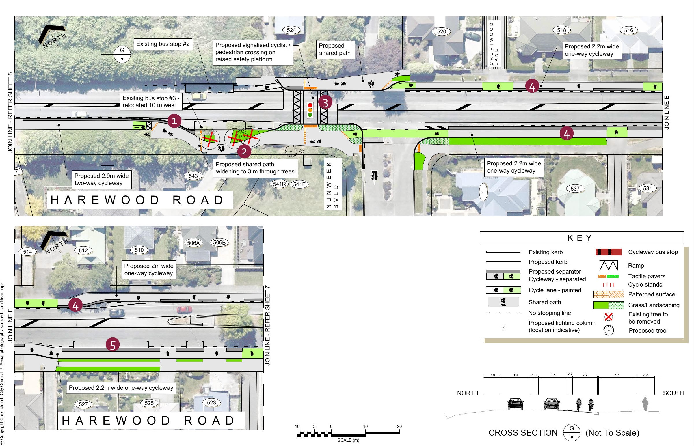
 Harewood Road - 547 to 519

  1. The cycleway transitions back to a shared path to provide space for the bus stop.
  2. The existing path is widened to a 3m wide shared path to provide adequate space for people walking and cycling at this location.  This requires three trees to be removed.  Two replacement trees will be planted nearby.
  3. A new signalised cycle and pedestrian crossing on a raised safety platform connects the shared path to the cycleways east of Nunweek Boulevard.
  4. 2-2.2m wide one-way separated cycleways run along each side of Harewood Road.  On-street parking in the narrower section of the road is removed to fit the cycleways and retain the flush median.
  5. On-street parking is provided next to the cycleway where the road widens.

Raised safety platforms are being used increasingly to manage vehicle speeds at intersections and crossings on arterial roads in New Zealand and overseas.  The raised safety platforms proposed for use on Harewood Road are different to the steeper platforms used for traffic calming on local roads, in this case being designed for a maximum comfortable speed of 40 km/h.
7

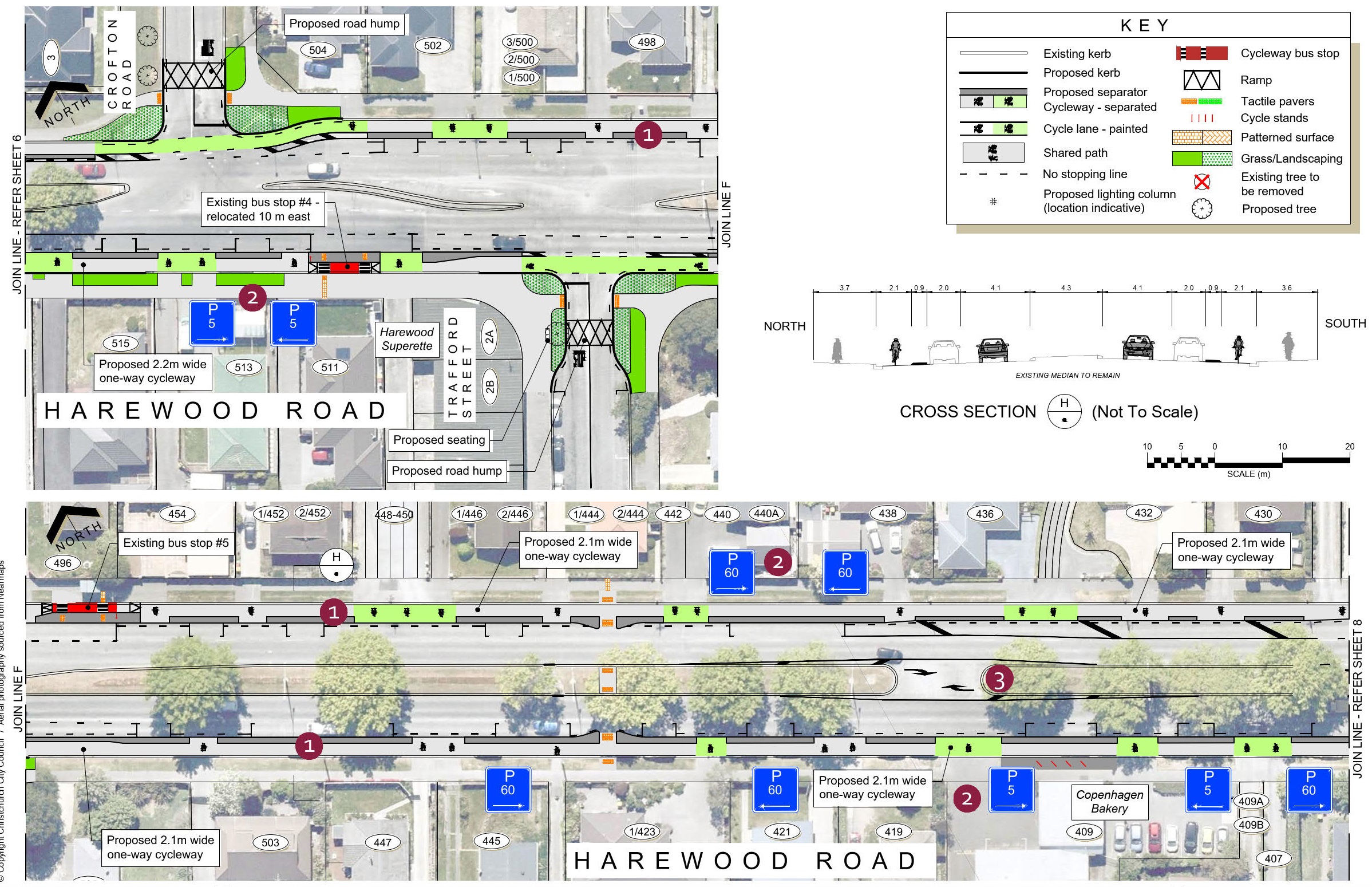
Harewood Road - Crofton Road to Copenhagen Bakery

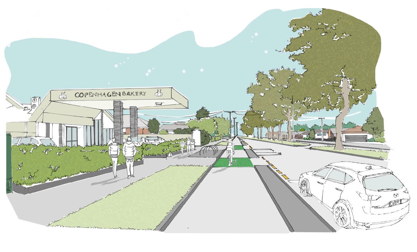
  1. 2.1m wide one-way separated cycleways run along each side of Harewood Road, removing a traffic lane in each direction.
  2. While on-street parking is provided on both sides of the road, the amount provided is reduced to provide adequate visibility for drivers and riders at driveways and side roads, as well as to make other improvements for safety and access at bus stops and pedestrian crossing points.  P5 and P60 parking spaces are provided outside businesses in this area to help maintain convenient parking for customers and other visitors to the area.
  3. Markings are added to create more width for vehicles waiting to turn at the U-turn pockets.

Council consulted on and approved a scheme in 2010 to remove a traffic lane in each direction and install cycle lanes on this section of Harewood Road, however, this was never implemented due to the earthquakes.
 8

Harewood Road - Gardiners Road, Breens Road intersection

New traffic signals at the intersection with Gardiners and Breens Roads, approved by Council in 2019, are incorporated into the cycleway design.

1.8-2.2m wide one-way separated cycleways run along each side of Harewood Road, removing a traffic lane in each direction.

9

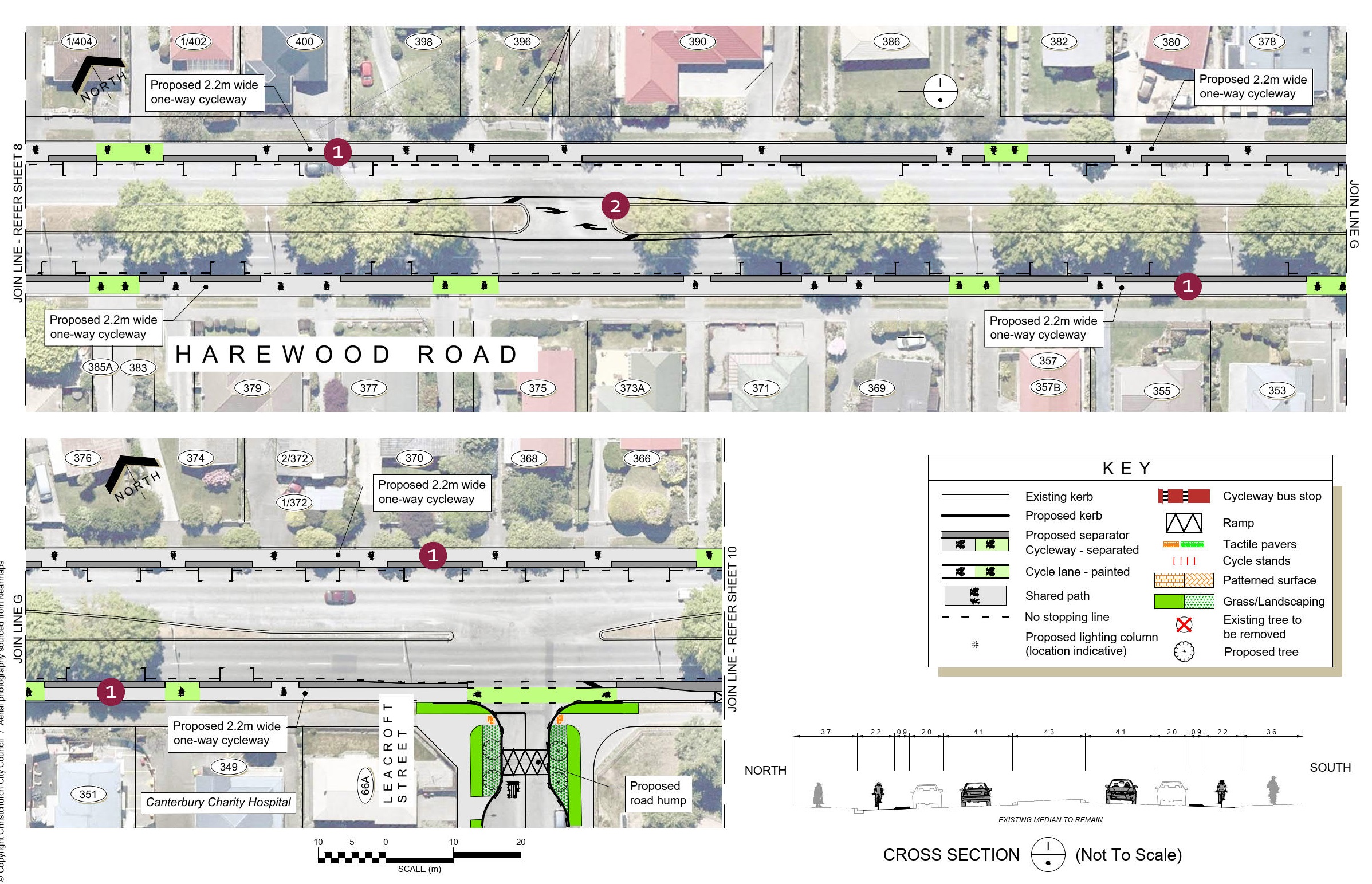
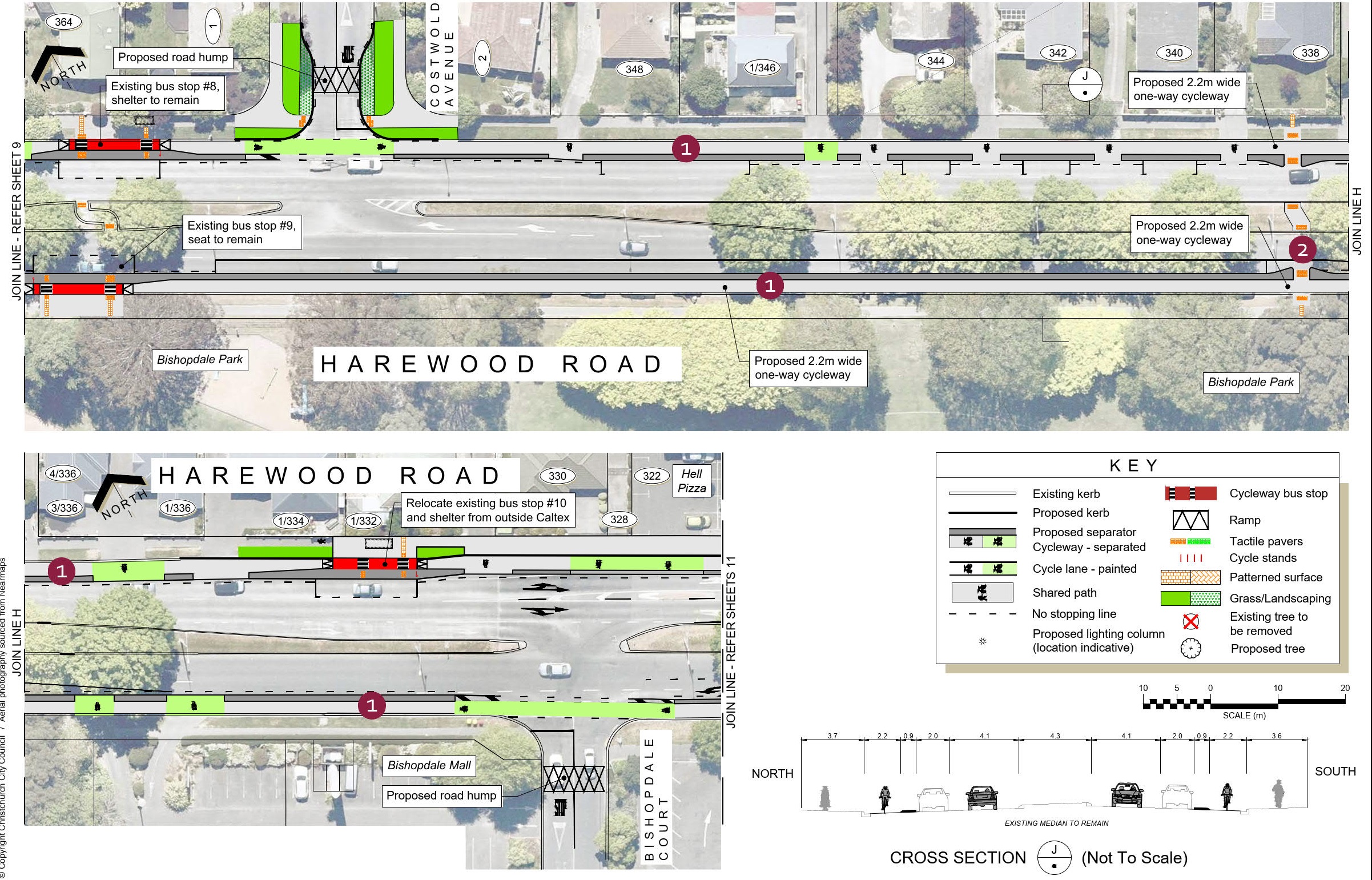
Harewood Road - 404 to 364

  1. 2.2m wide one-way separated cycleways run along each side of Harewood Road, removing a traffic lane in each direction.
  2. Markings are added to create more width for vehicles waiting to turn at the U-turn pockets.

On urban roads with traffic volumes such as those on Harewood Road, it is the intersections that dictate how traffic flows, not the number of lanes between intersections.  Removing a traffic lane encourages lower traffic speeds and makes the road safer for drivers and pedestrians to cross.
10

Harewood Road - 364 to 322

  1. 2.2m wide one-way separated cycleways run along each side of Harewood Road, removing a traffic lane in each direction to the west of Bishopdale Court.
  2. The Harewood Road pedestrian crossing point is shifted further away from the carpark exit to improve safety.  This requires the removal of several on-street parking spaces.

Bus stops alongside separated cycleways feature a raised island between the bus stop and the cycleway. Passengers will step on and off the bus from the raised island.

While on-street parking is provided on both sides of the road, the amount provided is reduced to provide adequate visibility for drivers and riders at driveways and side roads, as well as to make other improvements for safety and access at bus stops and pedestrian crossing points.

 11

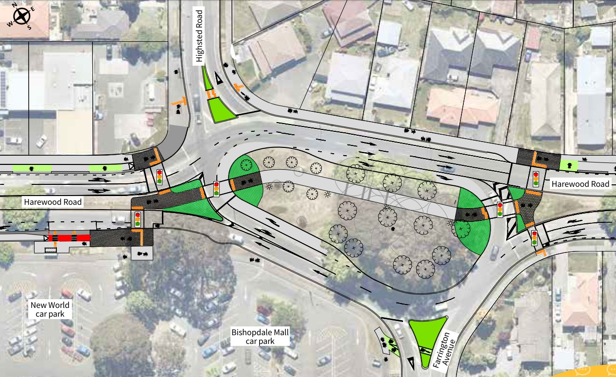
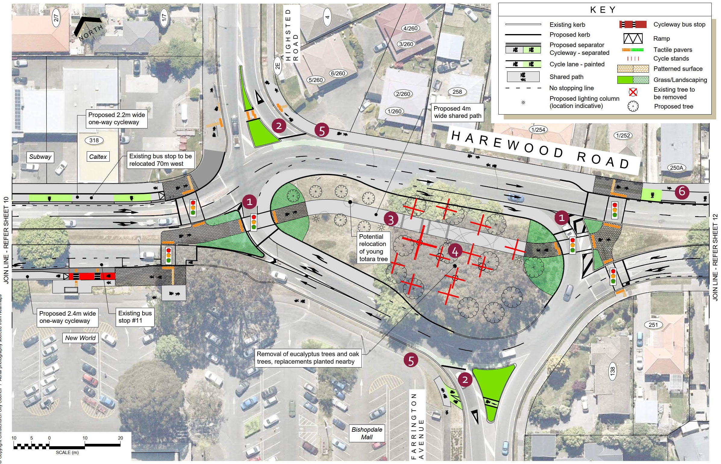
Bishopdale Roundabout

  1. New traffic signals at the east and west ends of the Bishopdale Roundabout will provide safe crossings for people cycling and walking through the roundabout and across Harewood Road.  They will also control traffic approaching and circulating within the roundabout.
  2. Drivers approaching on Highsted Road and Farrington Avenue will continue to give way to traffic approaching from their right.
  3. The cycleway takes the form of a 4m wide shared path through the centre of the roundabout.  New path lighting will be provided alongside the path.
  4. The removal of 12 trees in the centre of the roundabout is required.  Several oak trees need to be removed to fit the shared path and road widening.  The eucalyptus trees are removed as their falling branches pose a risk to path users, especially as they will be less stable due to the removal of the adjacent oak trees.  The remaining oak trees are removed as they are also at risk of becoming less stable, being interdependent on the surrounding trees.   Replacement trees proposed include exotic deciduous species alongside the path and natives in other parts of the roundabout.
  5. Connections on and off the cycleway from Highsted Road and Farrington Avenue are provided via shared paths on the outside of the roundabout and improved crossing points in the traffic islands of both roads.
  6. East of the roundabout, the cycleway joins another short section of shared path on the northern side of Harewood Road, which transitions to a two-way separated cycleway.

Multiple design options were investigated for the cycleway to negotiate the roundabout.  This option of partially signalising the roundabout provides the least delay for cycleway and road users, while providing safe crossings along the cycle route as well as across Harewood Road.
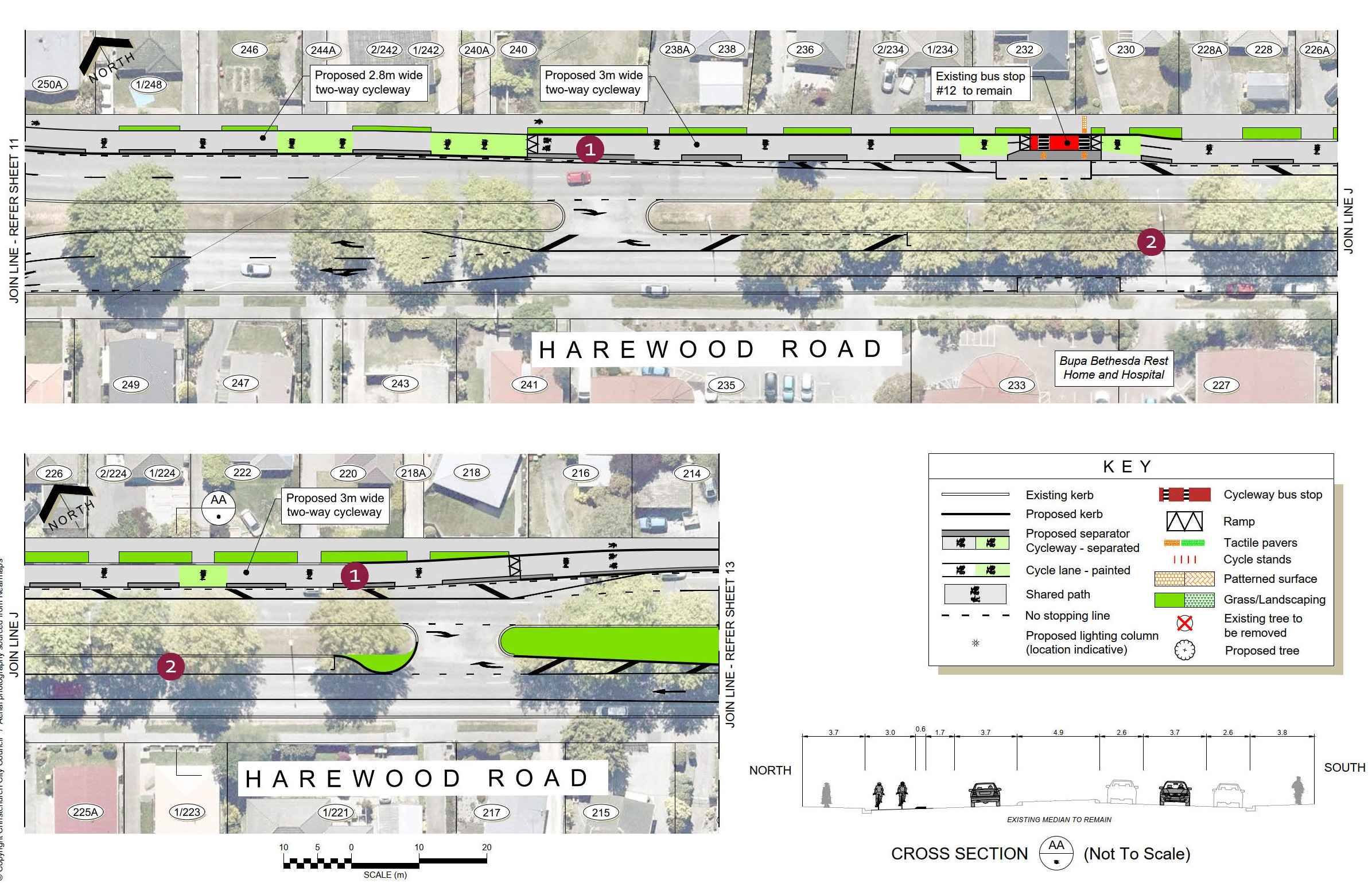
 12

 Harewood Road - 250A to 214

  1. A 2.8-3m wide two-way separated cycleway runs along the northern side of Harewood Road.  On-street parking next to the cycleway will be removed to fit the cycleway as well as to provide enough lane width for vehicle movements.
  2. Additional on-street parking is provided adjacent to the central median on the southern side of Harewood Road.  This requires the removal of one westbound traffic lane but provides more space for vehicles waiting to turn at the U-turn pockets.

On urban roads with traffic volumes such as those on Harewood Road, it is the intersections that dictate how traffic flows, not the number of lanes between intersections.  Removing a traffic lane encourages lower traffic speeds and makes the road safer for drivers and pedestrians to cross.
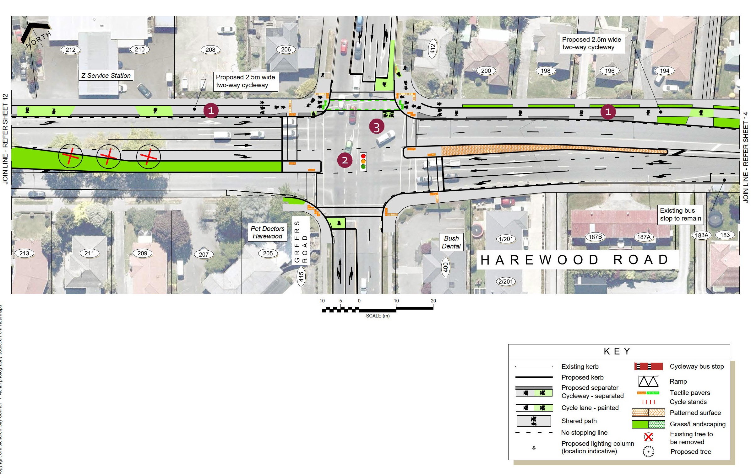
 13

Harewood Road and Greers Road intersection

  1. The two-way cycleway narrows to 2.5m in width around the Greers Road intersection.  This allows sufficient space to fit pedestrian refuges in the central median and to provide the traffic lanes required to enable the safe and efficient operation of the intersection. The cycleway is expected to be located behind the kerb, with another low kerb separating the cycleway from the footpath.  This will be confirmed during detailed design and in conjunction with drainage design and underground service locations.
  2. Additional safety improvements at the intersection include red arrows for turning traffic as pedestrians cross and providing green arrows for right-turning drivers.
  3. Cycle access on and off the two-way cycleway is provided through access ramps and a double hook turn box.

The works at the Greers Road intersection will include safety improvements for people walking and driving as well as cycling.
14

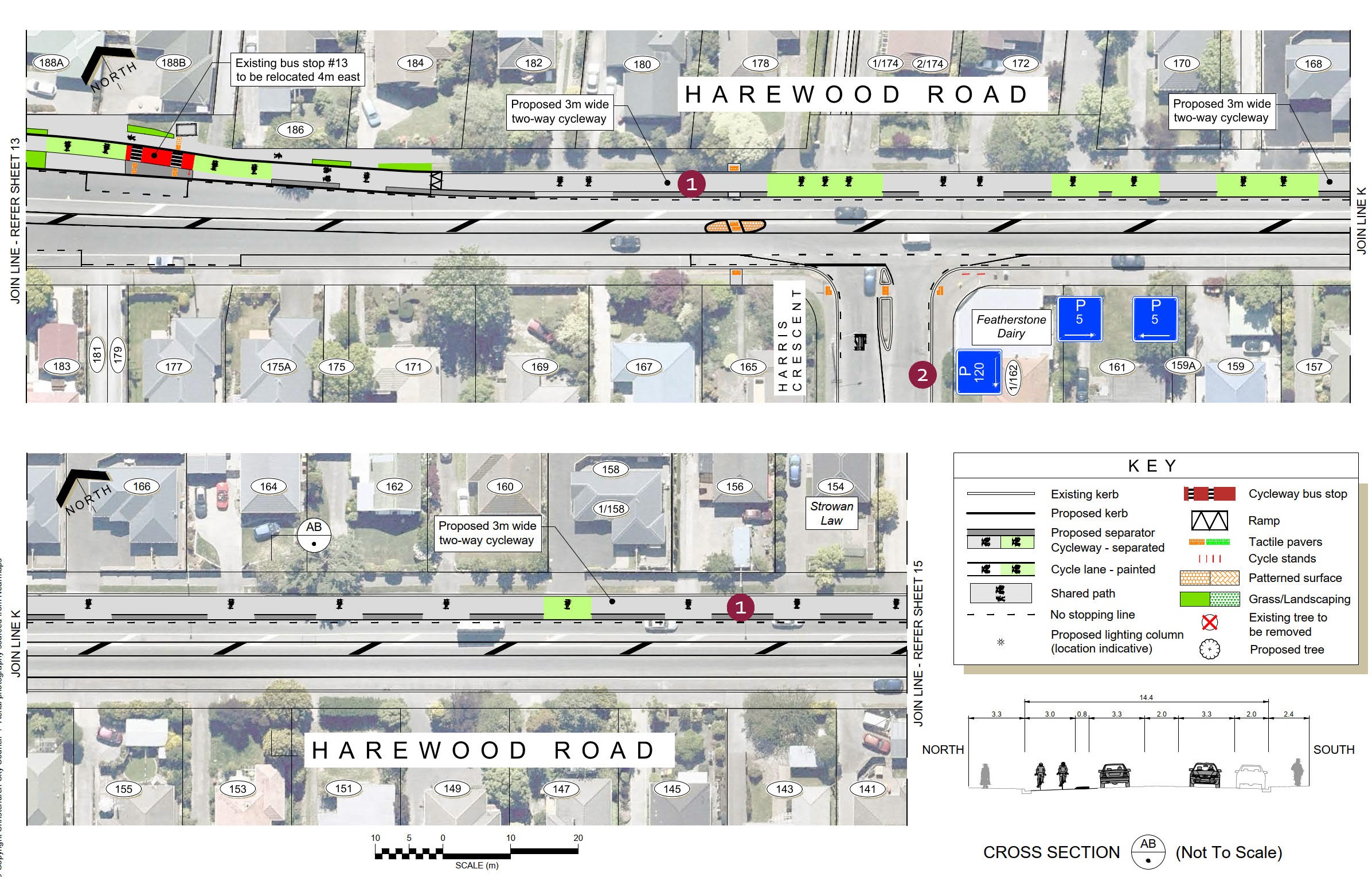
 Harewood Road - 188A to 154

  1. A 3m wide two-way separated cycleway runs along the northern side of Harewood Road.  On-street parking next to the cycleway will be removed to fit the cycleway and retain the flush median for use by turning traffic.
  2. Time-restricted parking is provided at key locations and on side roads to help maintain convenient parking for customers and other visitors to the area.  The extents of parking restrictions are shown in the attached plan.

One-way separated cycleways were considered for this section of Harewood Road; however, to fit the required lane widths and the flush median, all on-street parking would have needed to be removed.
15

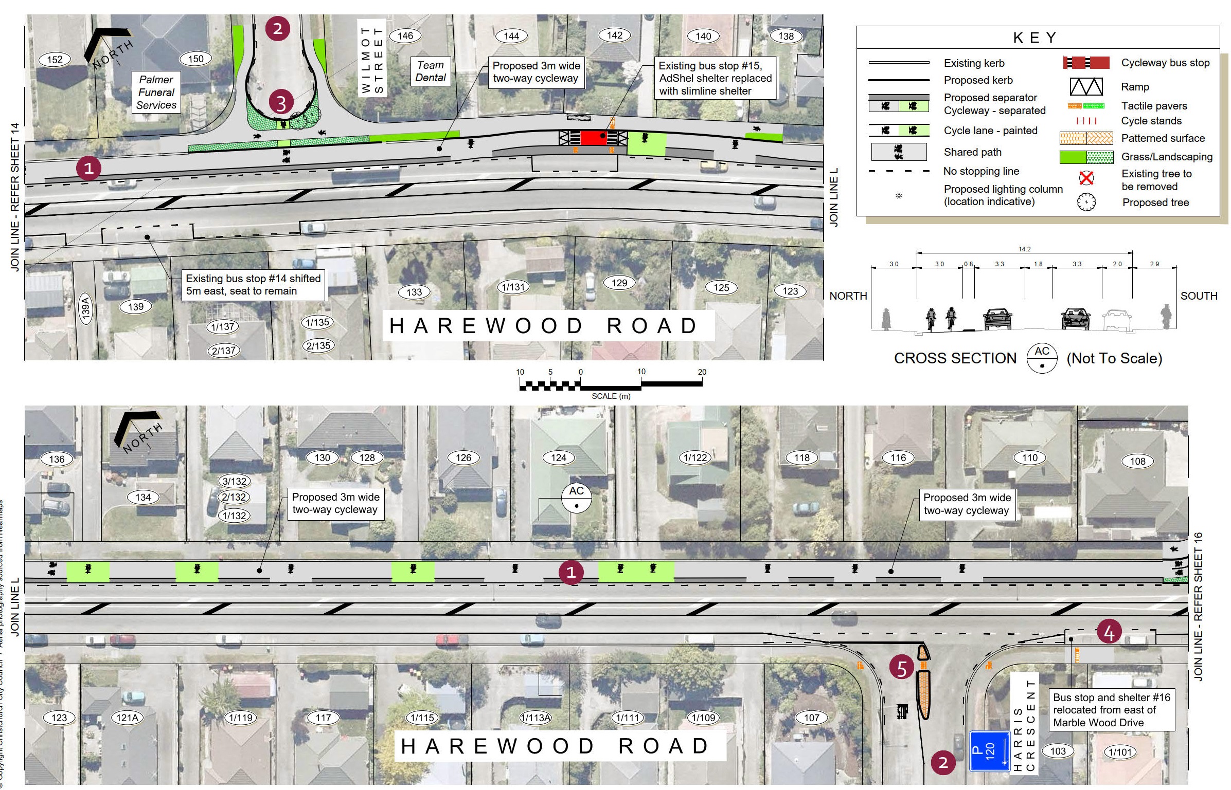
 Harewood Road - 152 to 108

  1. A 3m wide two-way separated cycleway runs along the northern side of Harewood Road.  On-street parking next to the cycleway will be removed to fit the cycleway and retain the flush median for use by turning traffic.
  2. Time-restricted parking is provided at key locations and on side roads to help maintain convenient parking for customers, residents, deliveries, and other visitors to the area.  The extents of parking restrictions are shown in the attached plan.
  3. To improve safety for people cycling on the two-way cycleway, Wilmot Street is closed at Harewood Road and a new cul-de-sac constructed.
  4. The westbound bus stop currently located near Marble Wood Drive is shifted 100m west to Harris Crescent to better space the bus stops along this part of the route, following changes proposed to other stops further east.
  5. A new refuge island on Harris Crescent makes it easier for people to cross this wide intersection.

Access restrictions at Sails and Chapel Streets are also proposed as part of this project. Refer to Sheet 16.  Access to and from the surrounding area has been considered as part of the design.
16

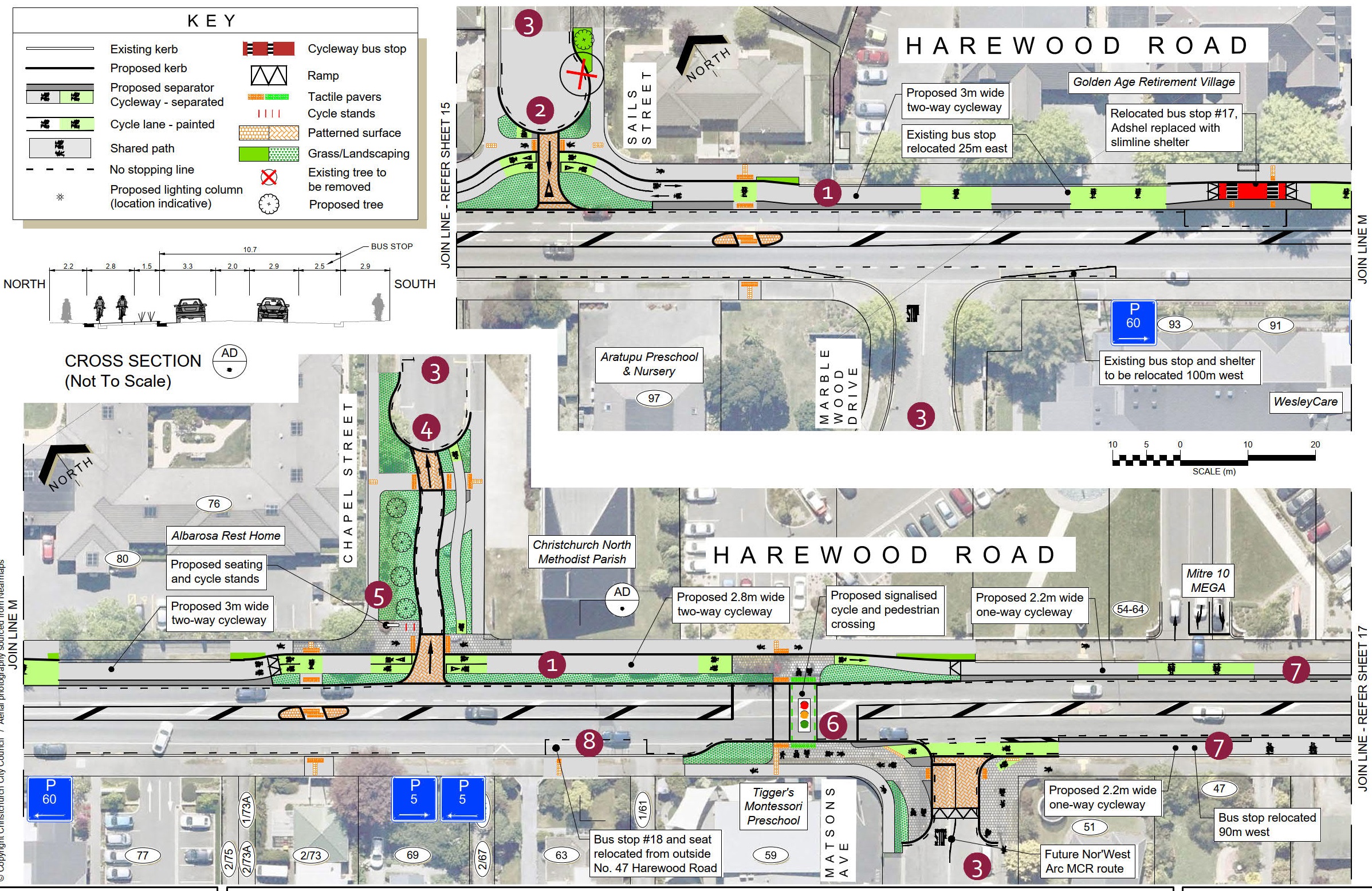
 Harewood Road (Sails Street to Mitre 10 MEGA)

  1. A 2.8-3m wide two-way separated cycleway runs along the northern side of Harewood Road.  On-street parking next to the cycleway will be removed to fit the cycleway and retain the flush median for use by turning traffic.
  2. Sails Street is changed to exit-only onto Harewood Road to simplify the intersection layout and improve safety for people cycling on the two-way cycleway.  A cul-de-sac head is provided for vehicles to turn around to access parking on the western side of Sails Street. This requires the removal of one tree.  A replacement tree is planted nearby, along with other landscaping improvements.
  3. Time-restricted parking is provided at key locations and on side roads to help maintain convenient parking for residents, deliveries, and visitors to the area.  The extents of parking restrictions are shown in the attached parking plan.
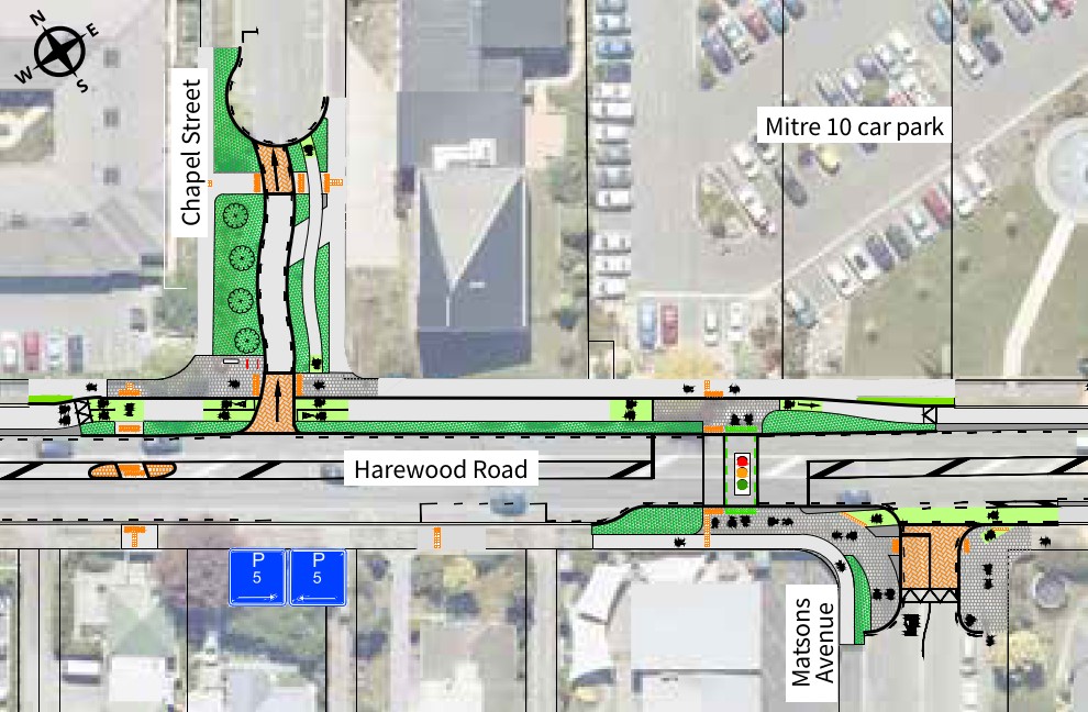
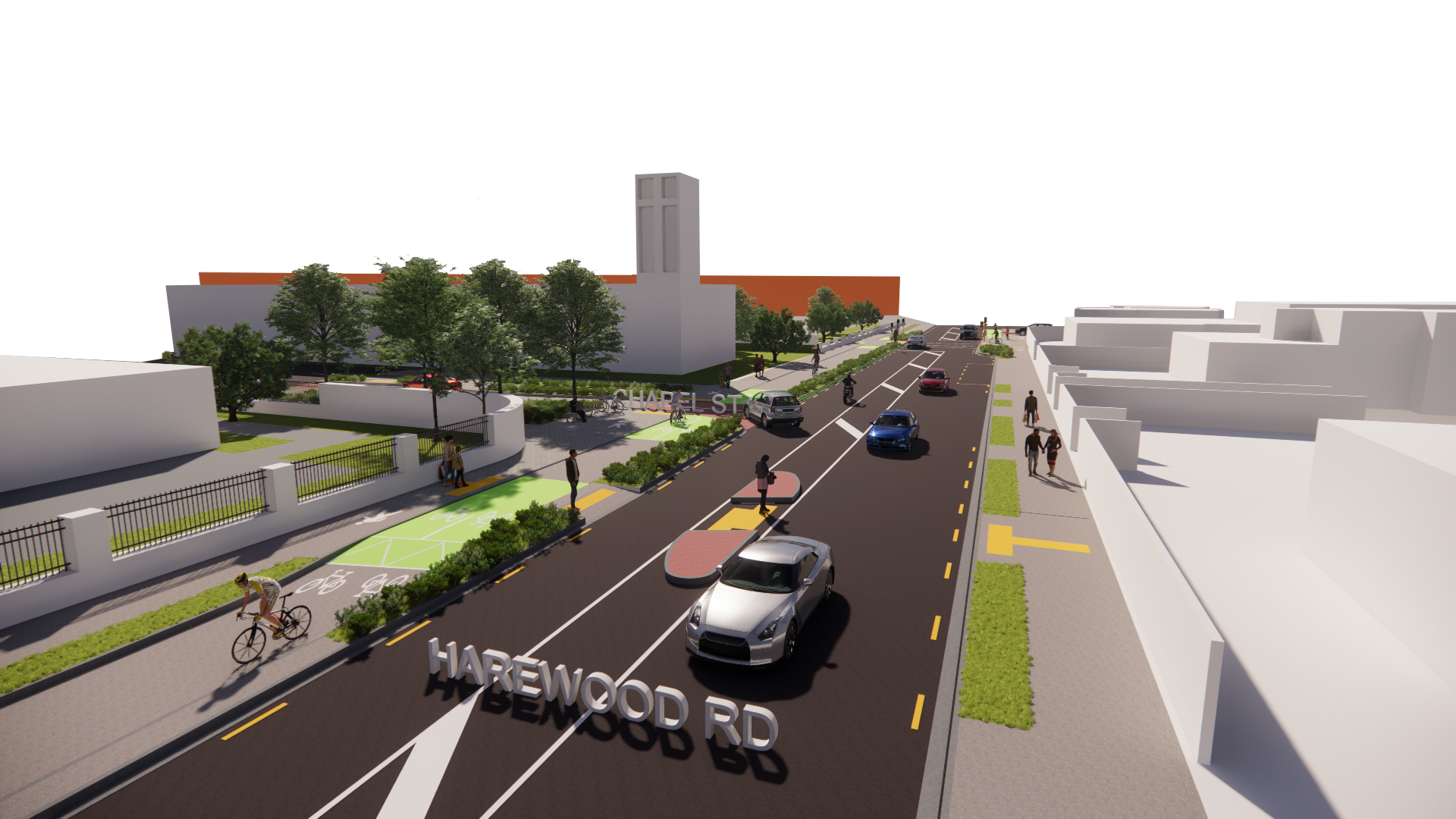
  4. Chapel Street is changed to entry-only from Harewood Road to simplify the intersection layout and improve safety for people cycling on the two-way cycleway.  A cul-de-sac head is provided for vehicles to turn around to exit the street to the north.
  5. Landscaping enhancements at the Chapel Street intersection includes new trees, shrubs and seating.
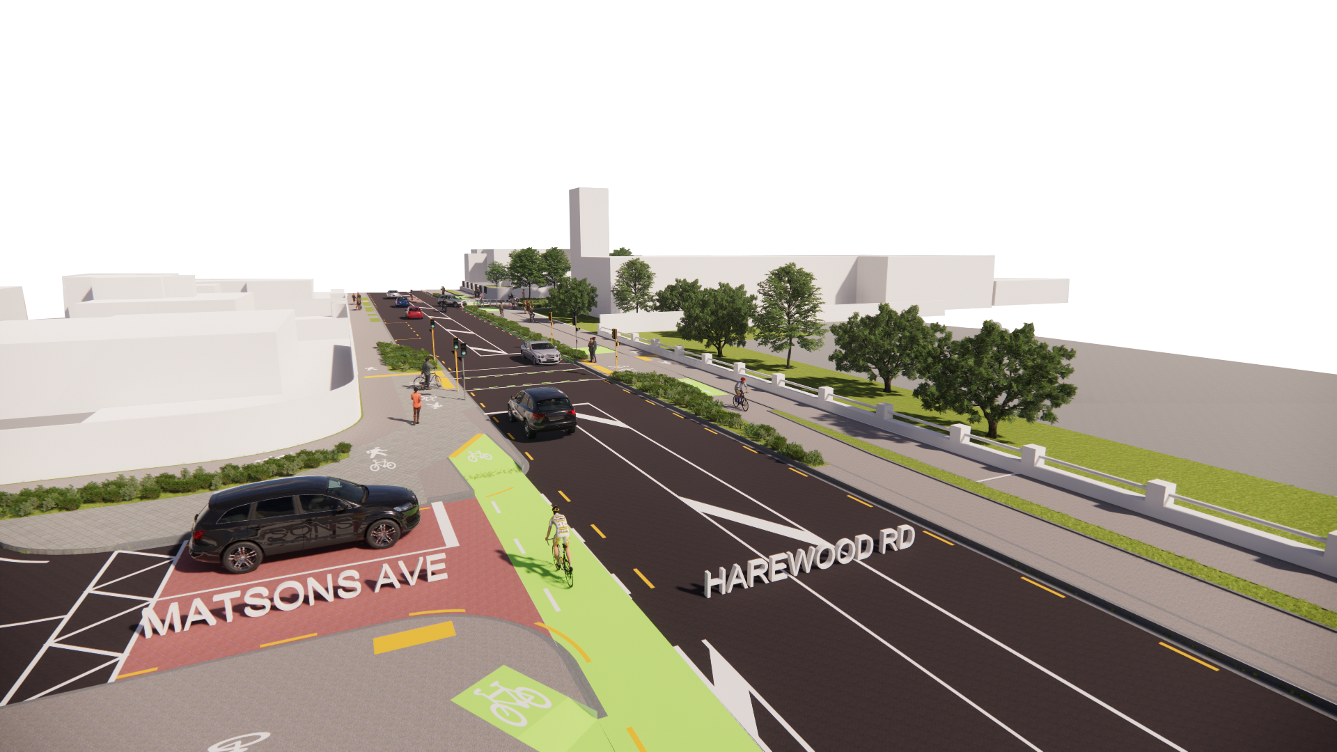
  6. East of Matson Avenue, a new signalised pedestrian and cycle crossing connects the two-way cycleway to one-way cycleways on each side of the road, as well as to the future proposed Nor’West Arc Major Cycle Route on Matsons Avenue.  This section of the Nor’West Arc MCR is still in early stages of design and subject to consultation later in 2021.  The Wheels to Wings design will accommodate different types of cycleway on Matsons Avenue.
  7. 2.2m wide one-way separated cycleways run along both sides of Harewood Road.  On-street parking next to the cycleways will be removed to fit the cycleway and retain the flush median for use by turning traffic.  One-way separated cycleways were selected for this section of Harewood Road to create a more intuitive facility to help all road users safely navigate this busy area with numerous side roads, the Mitre10 access and the junction of three Major Cycle Routes.
  8. The westbound bus stop currently outside No. 47 Harewood Road is shifted 90m west, to past Matsons Avenue.  This avoids the need for an in-lane bus stop opposite the Mitre10 accessway.
17

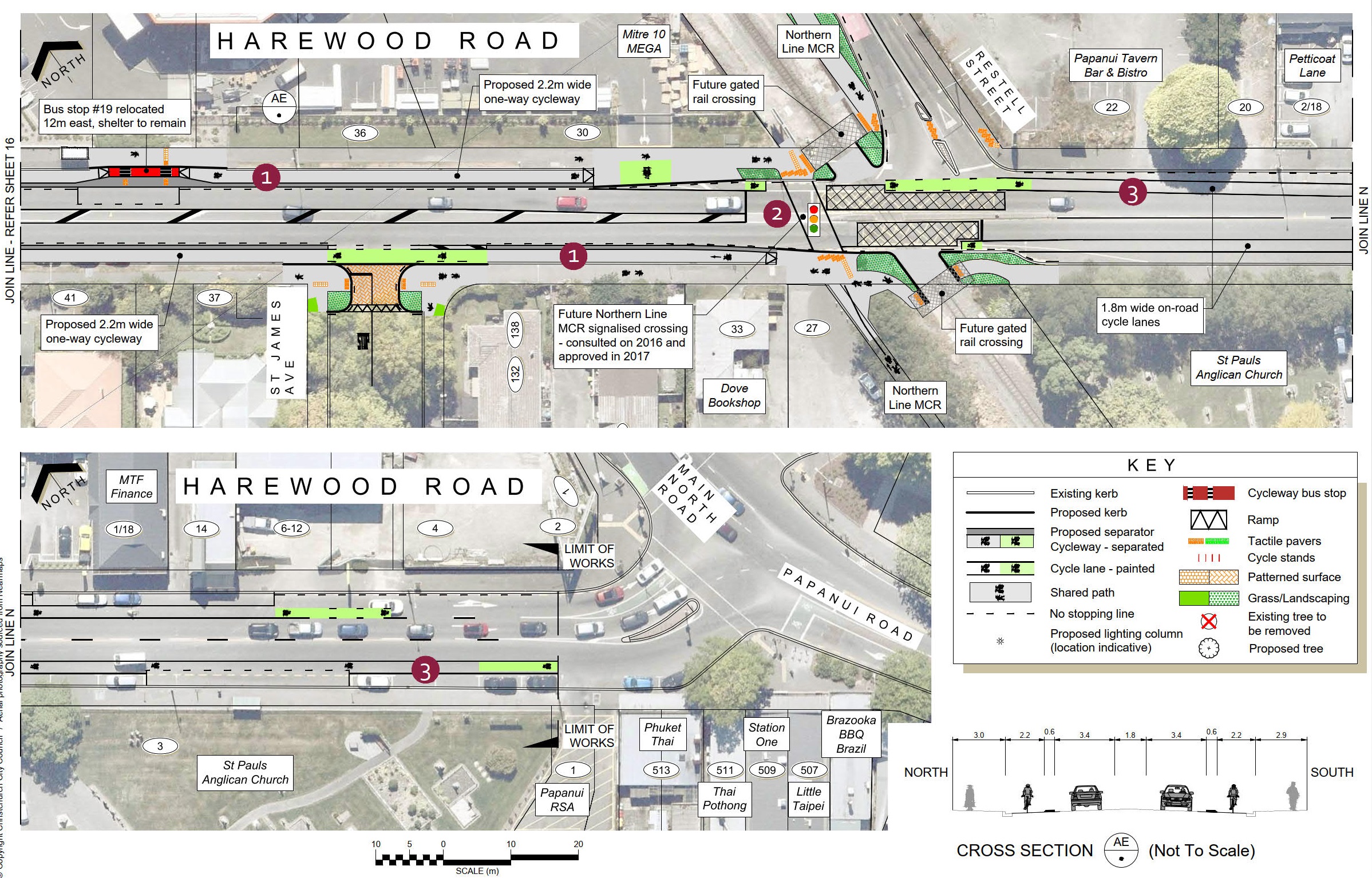
 Mitre 10 MEGA to Papanui Road

  1. 2.2m wide one-way separated cycleways run along both sides of Harewood Road.  On-street parking next to the cycleways will be removed to fit the cycleway and retain the flush median for use by turning traffic.  
  2. The Wheels to Wings Major Cycle Route connects into the Northern Line Major Cycle Route at the rail crossing.  The Northern Line Major Cycle Route was consulted on in 2016 and approved by Council in 2017, and includes a new signalised pedestrian and cycle crossing over Harewood Road.
  3. Painted cycle lanes to the east of the Northern Line provide an improved connection for more experienced cyclists through to Main North and Papanui Roads.

One-way separated cycleways were selected for east of Matsons Avenue to create a more intuitive facility to help all road users safely navigate this busy area with numerous side roads, the Mitre10 access and junction of three Major Cycle Routes.

Cycleways background

We are developing a network of 13 major cycleways all across Christchurch linking shopping centres, businesses, schools, parks and popular recreation destinations all across Christchurch.

Cycleways are a proven way to improve the health of a city, reduce congestion, build stronger local economies and reduce the long-term costs of infrastructure. They are also a key part of our plan to reduce carbon emissions.

The cycleways we have built so far have been well used. A morning count of people biking into the central city showed that 20 per cent more people were biking in March 2020 than a year earlier. This increase follows a pattern of yearly increases since we began building a
network of major cycle routes around the city.

The Major Cycleways are different to other cycle lanes around the city. They are designed to cater to people who don’t feel comfortable riding on the road.

Share this

Who to contact

Ann Tomlinson,
Senior Engagement Advisor

How the decision is made

  • Hearing

Takiuru ki ā mātou ratonga
Log in to our services