We’d like to hear what you think about proposed plans for three pedestrian/cycle bridges (two replacement bridges and one in a new location) that will be developed along the Green Spine of the Ōtākaro Avon River Corridor.
Project status: Closed for feedback
Open for feedback: 2 June 2020 to 29 June 2020
Share this
Consultation has now closed
Update 27 August 2020
Feedback on pedestrian/cycle bridges in the Ōtākaro Avon River Corridor
In total, we received 91 pieces of feedback on the pedestrian / cycle bridges. This included feedback from the following groups and organisations:
- The Dallington Residents Association
- Avondale Neighbours Group
- Rise Up Richmond
- Greening the Red Zone
- Avebury House
- Richmond Community Garden Trust
- Generation Zero
- Canterbury DHB
More than half of the feedback received was, at least in part, positive about the bridges. People were particularly positive about the bridges being reinstated, and the opportunities this would bring.
However, many submitters were less positive about the designs of the bridges. Specifically, people mentioned:
- A dislike of the colour white (because it doesn’t blend into the environment).
- Concerns around lack of any cultural identity.
- Concerns around lack of community involvement in the designs to date, and the absence of any local ‘flavour’ (eg Medway’s twisted bridge).
People were particularly disappointed in the design of Medway Bridge, which was described as ‘very plain’, a ‘blank slate’ and ‘the least designed out of the 3’.
We also received comments from people who felt that building bridges was not a priority at this time (11 comments /12% of feedback received), with the Avondale Bridge specifically highlighted by six people as being unnecessary. On this point it’s worth mentioning that these bridges are funded by money from the Canterbury Earthquake Appeals Trust and are therefore not a cost to ratepayers.
An update on progress
We’ve been working with Matapopore on how we should incorporate Ngāi Tahu and mana whenua identity into the bridges and Dallington landing, and they are providing us with guidance on embedding cultural values and narrative.
Some people asked about how the bridges will be lit. We’re still confirming what lighting will be required where, but if it is required, it’s likely to be integrated into the bridge handrails. We’re also still determining exactly what wayfinding signage will be required, but we do know that there will definitely be signage to help people navigate their way around the corridor.
Table of all feedback received [PDF, 327 KB]
We’ve had to move the Snell Place Bridge approximately 40 metres so it doesn’t interfere with high voltage underground power lines. This new location actually helps to improve the bridge’s accessibility as we can now have a more gently sloping ramp (1:33 rather than 1:12). There will still need to be handrails at the top of the ramps for safety, as the ramps are 2.1m high at their highest point. This also helps make for a safer transition between the Dallington side, which is quieter, and the busy Avonside Roadside.
The colour of the Snell Place Bridge is now proposed to be green, which aligns with the design advice we’ve received from Matapopore, and the arches are now proposed to be made of wood rather than steel.
Some people asked if we could make the bridges entirely from timber, as a low carbon approach. Staff looked into this, but timber only has a 50-year design life and isn’t economical for bridges of more than 15 metres in length (Snell Place has a span of 30 metres, and Medway and Avondale are both 40 metres). Timber bridges also require more maintenance and that can create an ecological risk.

Snell Bridge concept 1

Snell Bridge concept 2

Snell Bridge Concept 3
The colour of the Medway bridge is now proposed to be a greyish brown, which aligns with the design advice we’ve received from Matapopore.
We received feedback asking why the right angles at the entrance to the bridge were necessary, when curves would be easier to navigate.
The Medway Bridge needs the balustrade at both ends because of the height difference between the bridge and the land. Having a more curved entrance was considered, but the height difference and the additional land that would be required to create the necessary slope for the curve meant that this option wasn’t progressed.
The right angles also help slow people down as they enter and exit the bridge, which makes it safer for all users.
Some people asked whether a reference to the old, twisted Medway Bridge could be included in the new bridge. We looked at how this could be done, but in the end determined that this reference was best achieved in the existing tribute to the old bridge on Avonside Drive.

Medway Bridge concept 1

Medway Bridge concept 2

Medway Bridge concept 3
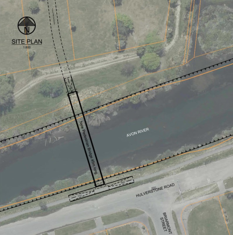
The Avondale Bridge will provide a new connection to land proposed for wetland regeneration. At both ends we now have a wooden ramp, as part of the bridge’s design to withstand future flooding.
Given the nature of this land, and how climate change might impact on river levels in the future, all the bridges and their entry points, have been designed to handle very heavy rain and flooding, and the impacts of future sea level rise. We’ve also been careful to design structures that span the whole river and have foundations that sit close to the stopbanks to keep additional flooding risk to a minimum.
The stopbanks in the Avondale Bridge area are quite high - 2.4 metres higher than the road. In order to connect the bridge to the road with a slope that’s accessible (1:33 gradient) we need to spread the ramps out onto the road. As a consequence, we’re going to be cul-de-sacing Hulverston Drive just before Briarmont Street, and closing Briamount Street at the river end.

Avondale Bridge Concept 1

Avondale Bridge Concept 2

Avondale Bridge Concept 3
Supporting safe, strong and healthy communities that are well connected to each other and with the wider city is one of the objectives of the Ōtākaro Avon River Regeneration Plan. Re-establishing connections that were severed due to the earthquakes, and making new connections through and across the area, are all part of how we can support communities, and encourage more people to enjoy the area more regularly.
We’ll be working with the Matapopore Charitable Trust to integrate Ngāi Tūāhuriri / Ngāi Tahu cultural values and narratives into the design of these bridges.
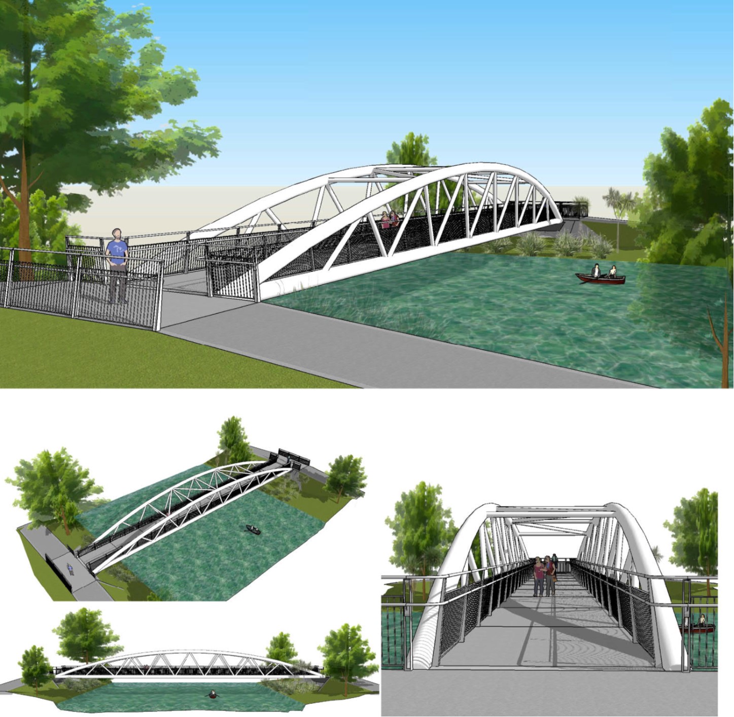
Avondale Bridge
This new bridge provides a connection between the Avondale and Aranui communities, the Donnell Sports Park and the future Eastern Reach wetland restoration area.
This steel truss bridge has a 45m span and is 4.5m high with a walkway that’s 3m wide. We’ve chosen a concrete deck to help minimise vibration, and to make it more resilient in any future earthquakes. It also has sliding and jackable abutments, to mitigate lateral spreading.
As the bridge is approximately 1m higher than the existing stopbanks, there are ramps leading up to it for access.
The design of the bridge will acknowledge the connection between Ngāi Tūāhuriri / Ngāi Tahu and Ōruapaeroa (Travis Wetland) which was once a kāinga mahinga kai (a food gathering place and settlement).

Artist impression
Avondale bridge plan
Medway Bridge
The Medway Bridge reinstates a pedestrian/cycle connection that has been missing since the previous bridge was famously buckled in the September 2010 earthquake.
In designing this bridge, we considered the expansive views and how the surrounding regeneration area creates a sense of space. The bridge’s white trusses are designed to blend in with the sky rather than the land.
This steel truss bridge has a 45m span and is 4.5m high with a walkway that’s 3m wide. We’ve chosen a concrete deck to help minimise vibration, and to make it more resilient in any future earthquakes. It also has sliding and jackable abutments to mitigate lateral spreading.
As the bridge is approximately 1m higher than the existing stopbanks, there are ramps leading up to it for access.
Artist impression
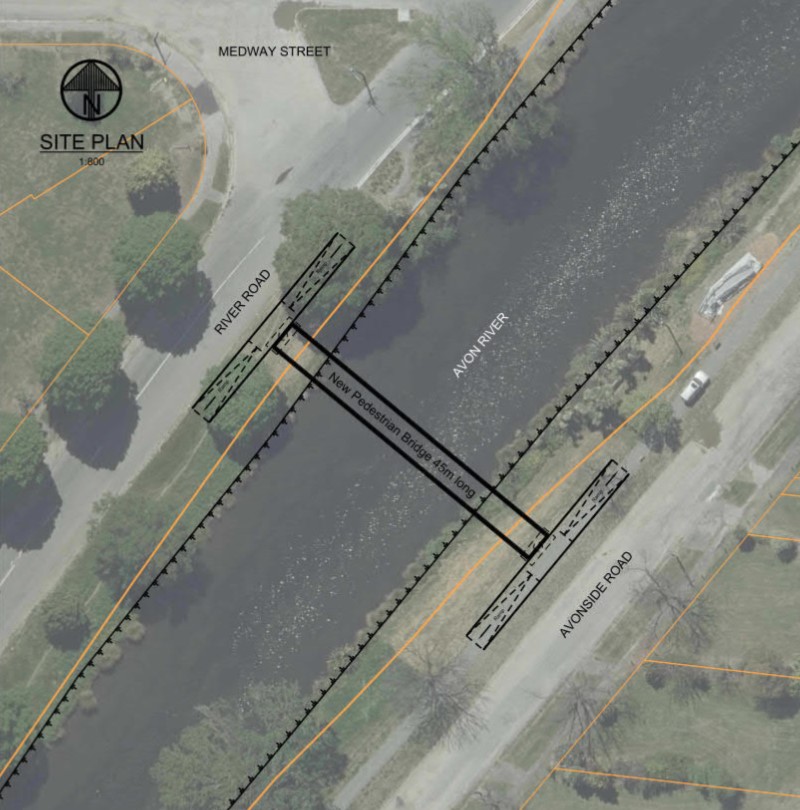
Medway bridge plan
Snell Bridge
The Snell Bridge follows the same alignment as the old pedestrian bridge that was damaged in the earthquakes. It reconnects Dallington and Avondale and provides an important connection to and from Avon Park.
In designing this bridge, we considered the forest regeneration planned for this area, and how the bridge could create a connection between land, water and sky. The arches are designed to draw the eye upwards, with the white trusses creating a connection with the sky.
This steel truss bridge has a 35m span and is 4.5m high with a walkway that’s 3m wide. We’ve chosen a concrete deck to help minimise vibration, and to make it more resilient in any future earthquakes. It also has sliding and jackable abutments to mitigate lateral spreading.
As the bridge is approximately 1m higher than the existing stopbanks, there are ramps leading up to it for access.
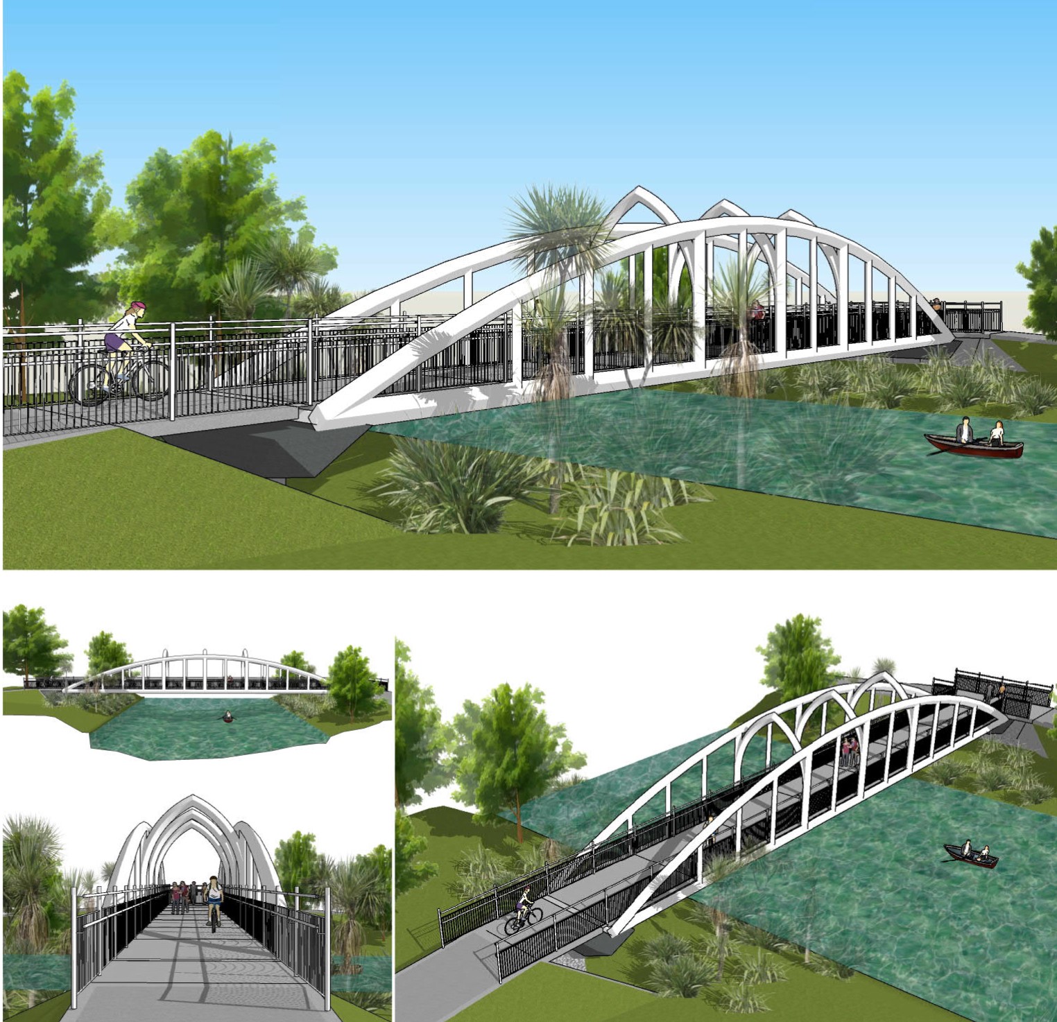
Artist impression

Snell bridge plan
We’re also seeking feedback on the Dallington Landing(external link) – the first of the riverside landings that will be developed along the Green Spine of the Ōtākaro Avon River Corridor.
In addition to the $144 million that the Council has set aside to invest into the Otākāro Avon River Corridor over the next 10 years, and the commitment of $40 million from the Government’s Christchurch Regeneration Acceleration Fund, the Council has received an additional $13,765,500 of funding from the Christchurch Earthquake Appeal Trust (CEAT). CEAT selected three pedestrian and cycle footbridges (two replacement and one new) and a landing at Dallington for funding.
The Green Spine forms the core of the Ōtākaro Avon River Regeneration Area. About eleven kilometres long and 345 hectares in size, it extends along both sides of the river and provides the thread that brings the Regeneration Area together.

As there are a lot of geotechnical constraints with the land next to the river, development of this area is focussed on restoring native habitats, wetland development and supporting public access. The Green Spine will include large areas of ecological restoration and wetlands, walking paths, nature trails, cycleways, riverside landings and community spaces such as picnic spots and barbecue areas.
To help deliver the Green Spine, the Council is using $40 million from the Christchurch Regeneration Acceleration Fund (CRAF) to create pathways and connections along the full length and across the corridor. Money from this fund is also being used to provide basic public facilities at up to seven landing sites, and to start an ecological restoration.
In addition, the Council has planned in its 2018-2028 Long Term Plan some major infrastructure projects within and through the corridor, including the replacement of Pages Road bridge, the City to Sea cycleway, stormwater treatment facilities and floodplain management.
