We’d like to hear what you think about proposed plans for the Dallington Landing – the first of the landings that Council will be developing along the Green Spine of the Ōtākaro Avon River Corridor.
Share this
 Project update: September 2021
Here are the latest designs for the Dallington Landing [PDF, 6.8 MB].
Construction has now started on the Landing - you can read more about that here(external link).
Project update: November 2020
We received feedback on the Landing from 29 submitters - all but two were in support of the landing.
Overall, there were two main themes to emerge from the feedback:
- Concerns for traffic management in the area, for how cars and cyclists interact, and a lack of support for Rupert Place as a car park.
- Questions about the location, and whether the landing should be on higher ground on the other side of the road / set back further to get away from traffic noise etc.
In response to concerns about traffic management in the area, we have removed the proposed carpark at Rupert Place. Instead, cars will be able to park on the street. This means a greater distance from parking to landing, but it does reduce the risk of unsafe traffic movements as cars enter and exit a car park, and also supports community sentiment for a landing that encourages walking and cycling (active transport).
While there are geotechnical and flood constraints with the land next to the river, the proposed location of the landing still remains the best place in that area in terms of land height, and access. The landing has been designed to allow intermittent flooding, with the exception of the toilet block which has been designed to meet building code floor levels.
The updated design takes into consideration the feedback we received about what is important to people. We've improved access to the river, improved cycling infrastructure and taken onboard recommendations to keep existing trees. The Landing will feature signposted entrances, shelters, koru-shaped pathways, picnic areas and tables, steps down to the river, a water fountain, bike parks, and a wheelchair-accessible toilet block. We've also worked alongside Mahaanui Kurataiao and Matapopore to ensure the design reflects mana whenua values and narratives.
You can read a table of all feedback here [PDF, 385 KB].
The Dallington Landing 
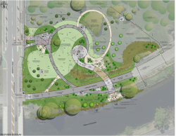
According to the Ōtākaro Avon River Corridor Regeneration Plan, this area of the Green Spine will be returned to native forest and wetlands in the future. With this in mind, the design inspiration for the Dallington Landing is a ‘picnic in a forest’. This Landing will also act as a gateway to welcome people into the corridor from the south.
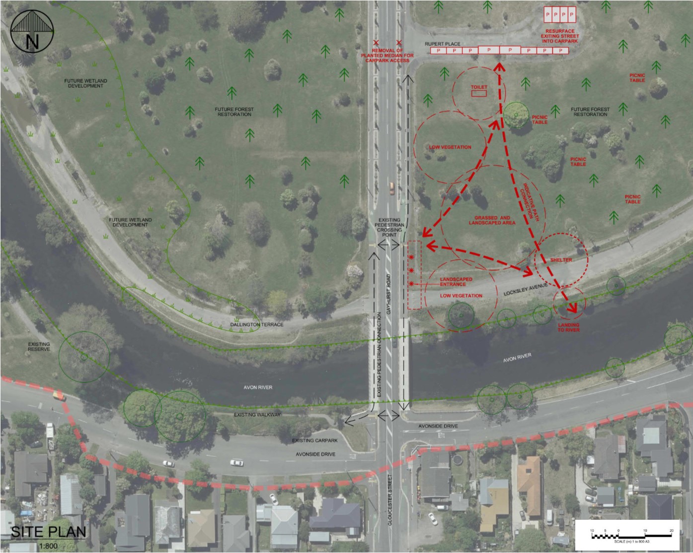
This plan is just a concept at this stage – it shows what things could be included, and where they could be located, but doesn’t go into detail. We’ll use the feedback we receive during this consultation to refine what’s proposed, and fine-tune the details.
We have to consider how we make the best use of our budget. Some of the elements in this plan, like installing toilets, are deceptively expensive, but they are also a key feature of making the Landing a functioning and desirable area. Your feedback on the features and elements you think need to be included will help us make sure we use the available budget to deliver the best possible outcome for the community.
We also have to consider how the area will develop in the years to come. How it looks now will be very different from how it will look in the future. The 11km City to Sea pedestrian and cycle path will loop through the area on its journey along the Green Spine. The area around the Landing will eventually be returned to native forest and wetland. There could be opportunities, as funding becomes available or as community initiatives are developed, to enhance things further. However, we want to get the basic infrastructure in place now, so more people can enjoy the area more easily.
We’ll be working with the Matapopore Charitable Trust to integrate Ngāi Tūāhuriri / Ngāi Tahu cultural values and narratives into the design of the landing.
Key features and elements of the Landing
- We’re planning to resurface Rupert Place to create parking, including two accessible parks.
- We’re proposing to build a toilet block that will include an accessible option. A drinking fountain is also planned.
- Continuing the theme of a ‘picnic in a forest’, picnic tables are proposed to be scattered through the area. A structure with partial or fully open walls is also planned, to provide some basic shelter from the elements.
- Planting (as indicated by ‘low vegetation’) will be designed to help support the regeneration of native plants in the area. It will also provide a noise and visual buffer between the Landing and the road, and help create a gateway that welcomes people into the area.
- The ‘grassed and landscaped area’ is something that will become more of a feature once the forest regeneration is underway. Currently, the whole area is very open, but in the future, this grassed area is intended to become a clearing in the forest.
- We aren’t planning any specifically-designed river access for kayaks or boats at this Landing. However, people will be able to access the river’s edge via timber steps.
- The red arrows indicate, generally, where the path connections would go.
We’re also seeking feedback on three pedestrian bridges(external link) (two replacement bridges and one in a new location) that will be developed along the Green Spine of the Ōtākaro Avon River Corridor.
In addition to the $144 million the Council has set aside to invest into the Otākāro Avon River Corridor over the next 10 years, and the commitment of $40 million from the Government’s Christchurch Regeneration Acceleration Fund, Council has received an additional $13,765,500 of funding from the Christchurch Earthquake Appeal Trust (CEAT). CEAT selected three pedestrian and cycle footbridges (two replacement and one new) and a landing at Dallington for funding.
The remaining landings will be developed over the coming years, as the area is developed and work is programmed.
The Green Spine forms the core of the Ōtākaro Avon River Regeneration Area. About eleven kilometres long and 345 hectares in size, it extends along both sides of the river and provides the thread that brings the Regeneration Area together. 
As there are a lot of geotechnical constraints with the land next to the river, development of this area is focussed on restoring native habitats, wetland development and supporting public access. The Green Spine will include large areas of ecological restoration and wetlands, walking paths, nature trails, cycleways, riverside landings and community spaces such as picnic spots and barbecue areas.
To help deliver the Green Spine, the Council is using $40 million from the Christchurch Regeneration Acceleration Fund (CRAF) to create pathways and connections along the full length and across the corridor. Money from this fund is also being used to provide basic public facilities at up to seven landing sites, and to start an ecological restoration.
In addition, the Council has planned in its 2018-2028 Long Term Plan some major infrastructure projects within and through the corridor, including the replacement of Pages Road bridge, the City to Sea cycleway, stormwater treatment facilities and floodplain management.

