We are asking for feedback an alternative option on Elizabeth Street before we present a final proposal to elected members who will make a final decision.
Share this
Initial consultation
Consultation on the South Express Major Cycle Route from Hagley Park to Templeton ran from 25 January to 20 March. We received over 650 submissions and have been reviewing these and looking at potential changes to sections of the route, where we received a number of comments or suggestions about a particular issue.
PLAN 1 - Elizabeth Street
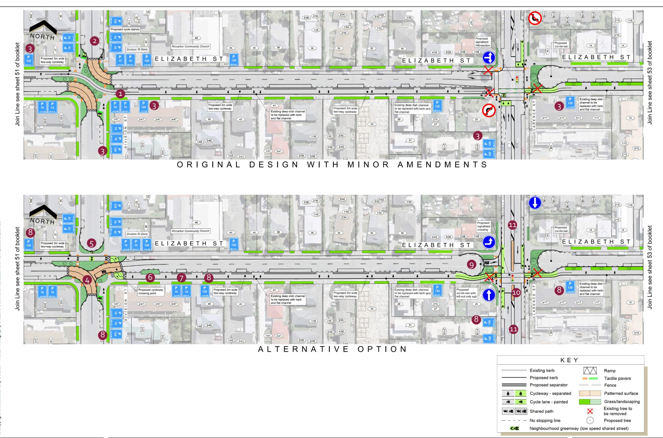
Original design with minor amendments
The original option has been amended to address on-street parking concerns. New short-term parking has been added near the corner of Elizabeth Street and Division Street and along Elizabeth Street.
Alternative option
An alternative option was developed following community feedback to maintain vehicle access along Elizabeth Street to and from Matipo Street and Division Street south.
To maintain safe cycling past Division Street, and to maintain traffic volumes along Elizabeth Street, access needs to be restricted at the intersections of Division Street and Clarence Street.
Elizabeth Street - Division Street to Clarence Street
The original design is still being considered, and several changes have been made to this design following initial community feedback
All parking restrictions apply between the hours of 8am and 6pm, unless otherwise stated on the sign.
Original design with minor amendments (top)
1. An additional parking space is created on the south side of Elizabeth Street, opposite the Division Street Dairy. This is designated as a P10 space.
2. Two P10 parking spaces are provided on the east side of Division Street outside the Division Street Dairy – these were P120 spaces in the initial design.
3. Two-hour parking is provided on one side of Elizabeth Street, Division Street and Clarence Street to help ensure on-street parking is available for people visiting the area. Refer to the Riccarton area parking time restrictions plan for further
details (Plan 4).
Alternative option
4. The intersection of Elizabeth Street with Division Street is reconfigured to maintain vehicle access along Elizabeth Street, and in both directions to and from the south side of Division Street.
5. People cycling along the route now need to cross the road to get over Elizabeth Street. To make the crossing safer and easier near an intersection, the north side of Division Street is closed at Elizabeth Street, creating a cul-de-sac.
6. In order to provide clear visibility at the crossing between people cycling and people driving, the parking space outside No. 47 Elizabeth Street needs to be removed for this option. This also means the additional parking space created as an amendment to the original design cannot be provided with this option.
7. The P10 parking space outside No. 47 Elizabeth Street is removed and a P10 space is designated between No. 47 and No. 45.
8. Two-hour parking is provided on one side of Elizabeth Street, Division Street and Clarence Street to help ensure on-street parking is available for people visiting the area.
9. Elizabeth Street is likely to attract additional traffic as an east-west through route with the installation of the traffic signals at Matipo Street, making the cycleway less safe at locations such as the new crossing. Turning restrictions are now required at Clarence Street to prevent this from happening. This is achieved with a cul-de-sac, with a left turn out onto Clarence Street being the only permitted turn.
10. The traffic-signal controlled intersection in the original design is replaced with a signalised crossing for pedestrians and cyclists, located close to the exit from Elizabeth Street onto Clarence Street. A raised median island is required along Clarence Street at this location to help prevent drivers making the banned turns. For example, turning right out of Elizabeth Street onto Clarence Street, which can put people crossing the road on foot or by bike at risk.
11. The alternative intersection design with the raised median islands results in some changes to parking on Clarence Street from the original design. Parking spaces are gained in some locations and lost in others. The total number of spaces is similar for both options.
PLAN 2 - Elizabeth Street/Matipo Street revised layout
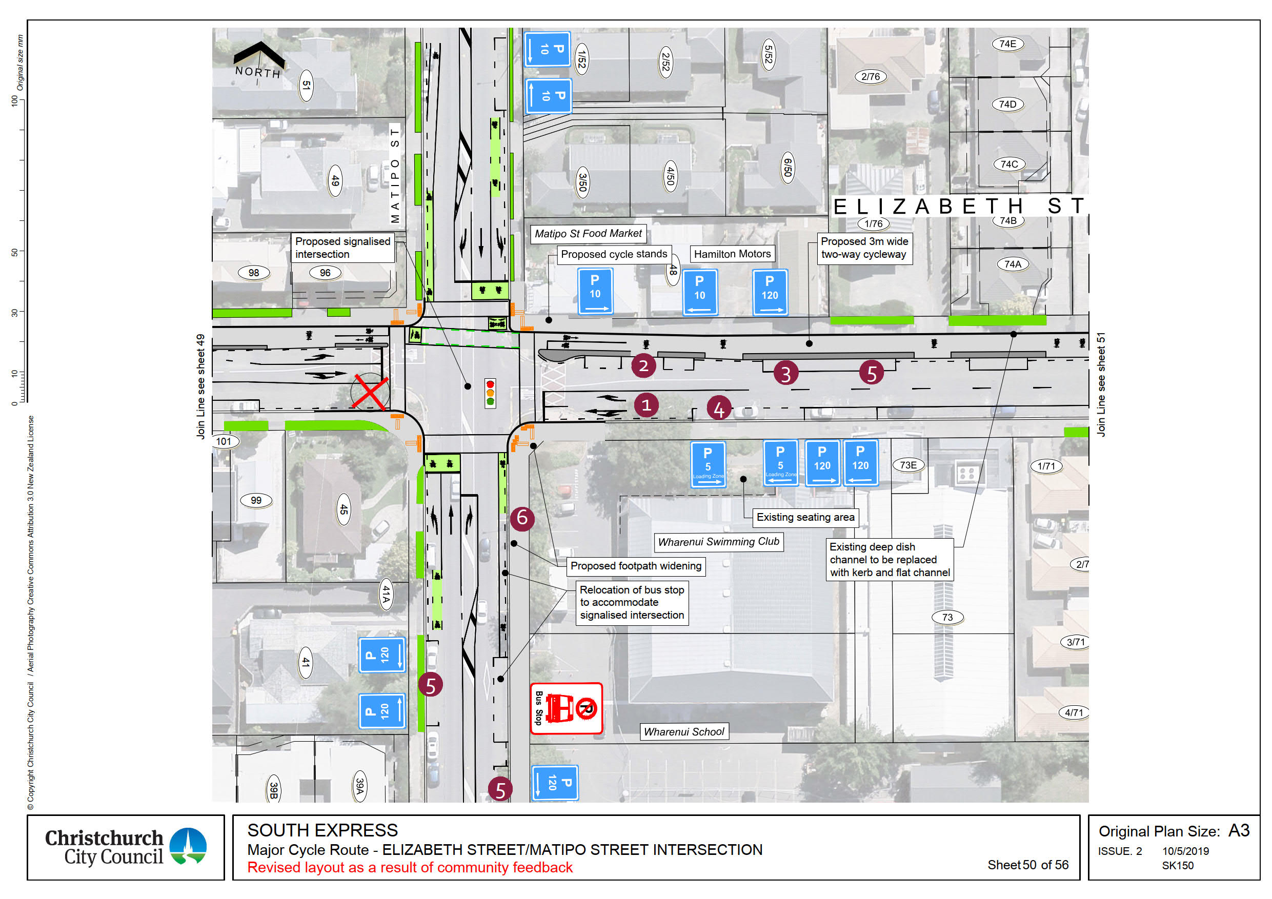
In response to feedback about parking, the intersection layout has been amended to provide short term parking outside the dairy, and additional carparks outside Wharenui Pool.
The eastern Elizabeth Street approach to Matipo Street has been amended to provide a separate right turn and straight ahead lane.
All parking restrictions apply between the hours of 8am and 6pm, unless otherwise stated on the sign.
Elizabeth/Matipo Intersection
1. The traffic lanes on Elizabeth Street are altered to allow additional parking to be provided on both sides of Elizabeth Street.
2. The two parking spaces are created on the north side, outside the Matipo Street Food Market and Hamilton Motors. These are P10 spaces; designated for 10-minute parking.
3. The two parking spaces designated P10 in the original design are now P120, two-hour parking.
4. Two parking spaces are created on the south side, outside the seating area by Wharenui Pool. The P5 Loading Zone is shifted west into these spaces, with two P120 spaces created in the resultant space.
5. Two-hour parking is provided on one side of Elizabeth Street and Matipo Street; refer to the Riccarton area parking time restrictions plan for
further details (Plan 4).
6. The grass berm is removed, and the footpath widened between Elizabeth Street and the Wharenui School pedestrian entrance.
PLAN 3 - Proposed parking restrictions
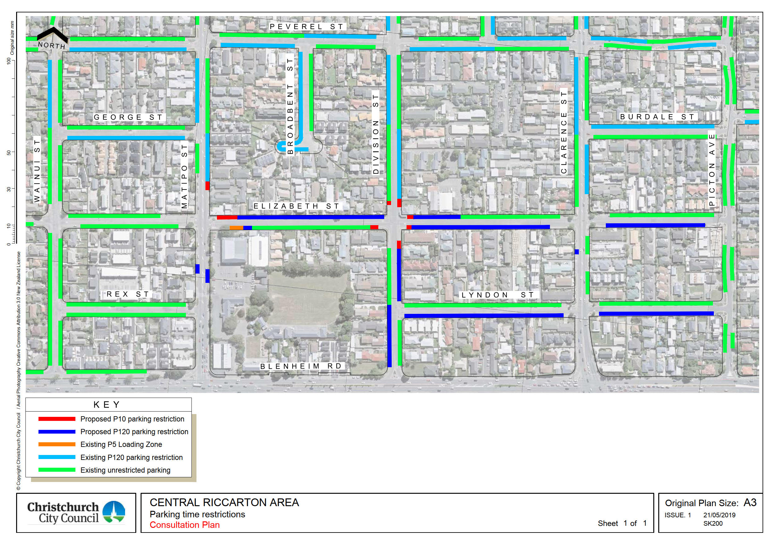
A number of people were concerned about the high number of workers who park in the area all day.
To make more parking available during the day we propose P120 restrictions (8am to 6pm, 7 days a week) on:
- Elizabeth Street (Matipo Street to Division Street) - north side
- Elizabeth Street (Division Street to Clarence Street) - south side
- Elizabeth Street (Clarence Street to Picton Avenue) - south side
- Division Street (Blenheim Road to Lyndon Street) - west side
- Division Street (Lyndon Street to Elizabeth Street) - east side
- Lyndon Street - south side
PLAN 4 - Wharenui School, 40km/h school speed zone
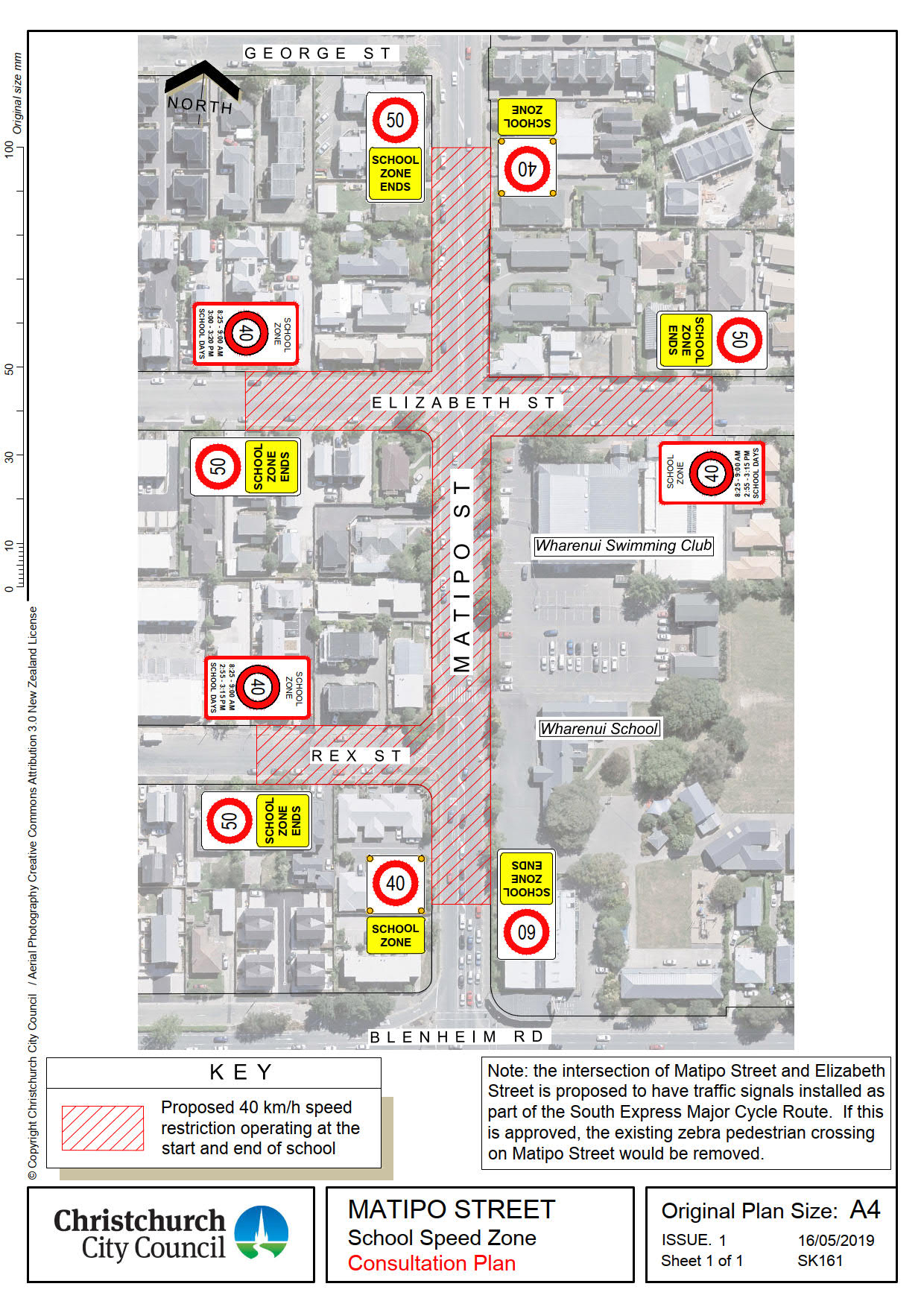
We propose a 40km/h speed zone on Matipo Street between Blenheim Road and 57 Matipo Street, to make it safer for the school children
The 40km/h speed restriction will only operate for 30 minutes during the morning school drop off and afternoon pick up times.
Outside of these times, the existing 50km/h will apply.


