This steep track takes you almost from sea to summit where you can connect with Trig V, the Crater Rim Walkway or the Summit Rd.
| Start | Lighthouse Lane, Governors Bay |
|---|---|
| Finish | Trig V near Summit Road |
| Distance | 2km |
| Time | One hour one way (uphill) |
| Toilets | Located at Sign of the Bellbird and Governors Bay Hall |
| Dogs | Dogs must be on a short leash |
| Description |
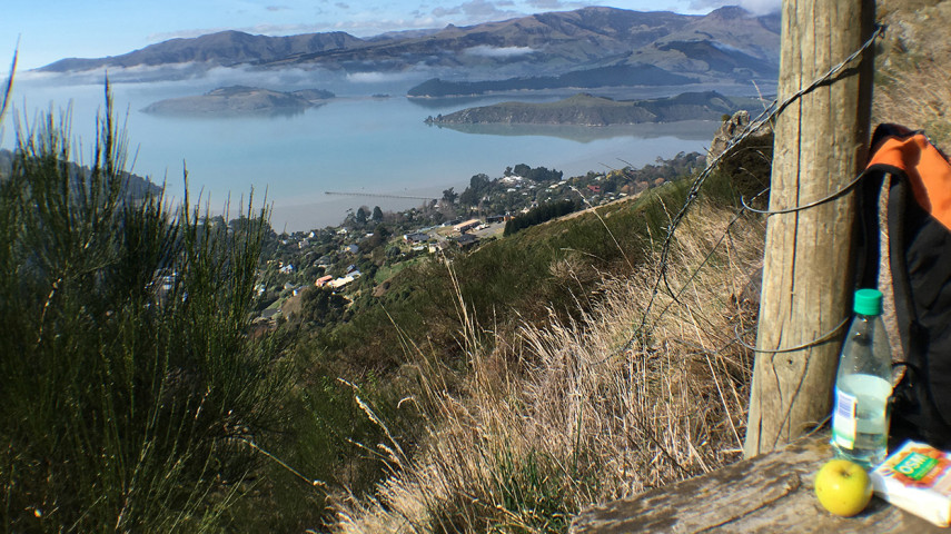
If you're starting in Governors Bay, you can access Faulkners Track at different points. Drive around to either Lighthouse Lane or The Terrace where there is parking, or you can walk up the lane directly off the main Governors Bay Road. From Lighthouse Lane, the track begins on the left - watch for a small sign. Cross The Terrace and head steadily up through the subdivision before zig-zagging through scrub and new plantings to reach the junction with South Boundary. Continue up a steep narrow path through rocky bluffs and into a bush gully past the North Boundary junction. Further on, take a short detour to a spectacular lookout point. The track meets Trig V as it crests the ridgeline. Link up with Trig V or the Crater Rim Walkway and other nearby tracks to create some satisfying walking routes. The tracks in Ohinetahi are managed by the Summit Road Society(external link). You can find maps and more information about the area on their website. |
Walking tracks
Shared use
Connecting tracks
Closed

Parking

Bus stop

Toilets
Water fountains
Accessible tracks

Challenging feature

Entry and exit point

Point of interest
Related news
New home for Linwood Keas
It’s going to be a good rugby league season for the Linwood Keas – on and off the field.
23 Apr 2026
Central city on full display after long rebuild
After the 15th anniversary of the 22 February earthquakes, we’re taking a look at different Council aspects of the rebuild, and how far we’ve come. Next up, the central city.
27 Feb 2026
Ōtākaro Avon River Corridor shines, grows since quake
In the wake of the 15th anniversary of the 22 February earthquakes, we’re taking a look at different Council aspects of the rebuild, and how far we’ve come. Next up, the residential red zone's Ōtākaro Avon River Corridor (OARC).
26 Feb 2026