These projects are planned to mitigate the effects of the Christchurch Northern Corridor opening.
Share this
Engagement on this project has now closed.
Waipapa/Papanui-Innes and Waikura/Linwood-Central-Heathcote Community Boards heard from submitters and considered the staff report(external link) on Monday 9 September 2019 and Friday 13 September 2019.
The recommendation(external link) of the Community Boards will be considered at the Council meeting on Tuesday 24 September, 9.30am start, Council Chambers, Civic Offices.
Community responses - Traffic calming, Reduced speed zones, Bus stop relocations, Cycle connections [PDF, 735 KB]
Submission attachments [PDF, 16 MB]
Consultation report [PDF, 760 KB]
We would like to thank everyone who has taken the time to give us feedback so far. Your input has helped to shape the work we have done to date. There is still a lot of work to do and we would appreciate your continued feedback in the next stages.
Introduction
The Christchurch Northern Corridor is due to open in mid-2020. We are working with our partner organisations to develop a plan for mitigating the expected increase in traffic on Cranford Street and other streets in a way that keeps everyone safe, encourages walking and cycling, use of public transport, and keeps people moving through the area.
Councillors have prioritised the first part of this plan and it needs to be done before the Christchurch Northern Corridor opens. They also instructed staff to investigate several other projects that are important to the community. Updates on these projects are provided below.
 Community feedback
Three themes have emerged from feedback we received during consultation in mid-2018 and early in 2019. These themes are:
- People, not cars
- Retaining a sense of community
- Safety, particularly for people walking, biking and accessing local schools
Information sessions
Come talk to us about our proposals:
Tuesday 6 August 2019, 5pm to 7pm
St Albans School Hall, 17 Sheppard Place, St AlbansThursday 8 August 2019, 5pm to 7pm
St Albans School Hall, 17 Sheppard Place, St Albans
Transport projects
Main road and intersection upgrades
Work along Cranford and Sherborne streets and at the intersections of Warrington and Forfar streets and Warrington and Barbadoes streets.
Traffic calming and turning restrictions
A range of approaches to discourage people from taking short-cuts through side streets.
Cycle routes
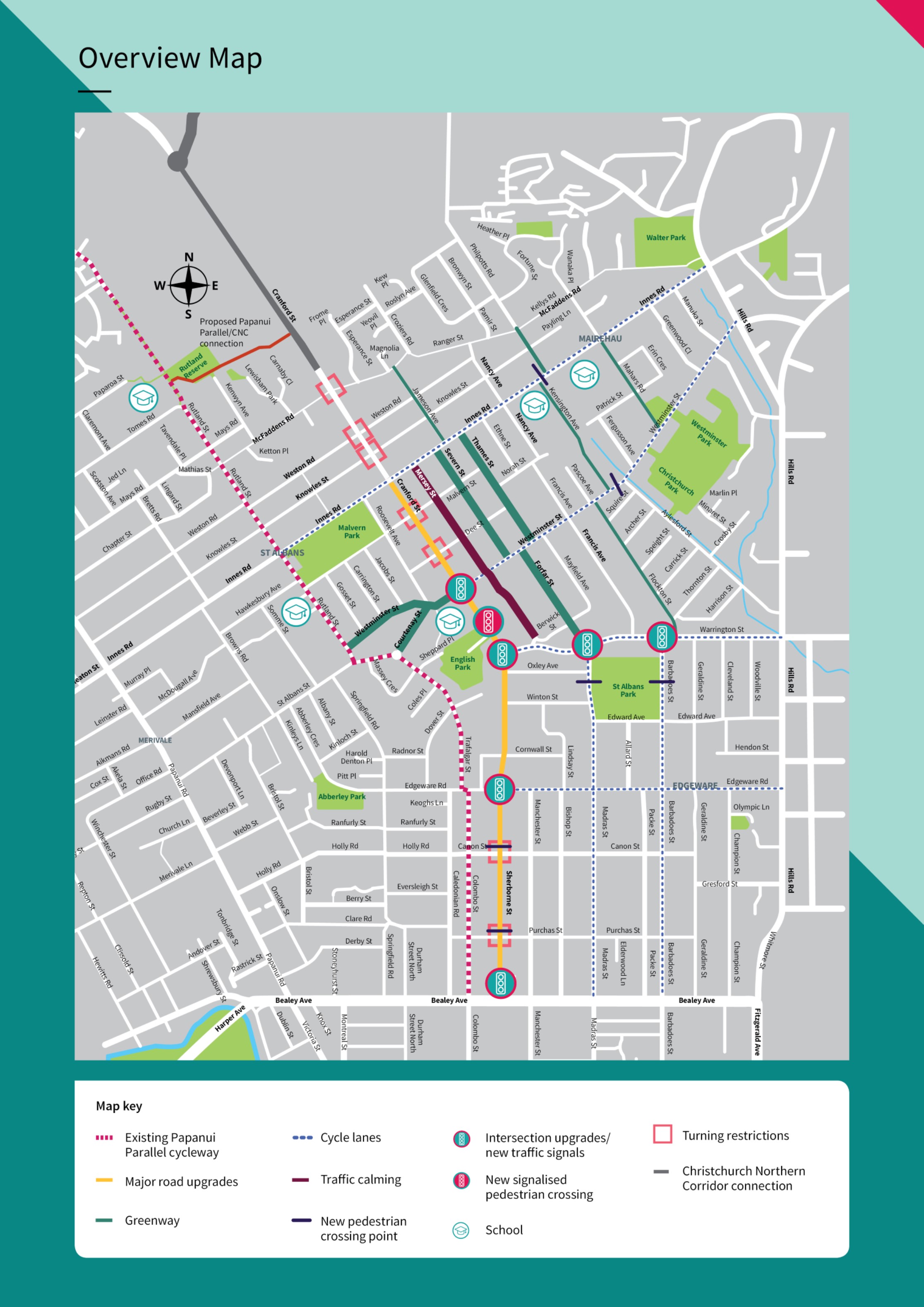
East-west connections across Cranford Street to the Papanui Parallel cycleway and two local north-south cycle routes to the east of Cranford Street.
Slow speed zone
A 40km/h speed zone between Rutland Street in the west and Hills Road in the east and an extension of the 30km/h speed zone in Edgeware.
Traffic and environmental monitoring
We will continue to monitor traffic volumes in the area and to work with specialists to develop an environmental monitoring programme.
 We heard your feedback that we need to work to reduce the amount of traffic on the roads. We agree, and this is a focus for the Council moving forward.
This consultation focuses on the work in the St Albans, Edgeware and Mairehau areas. We are working with our partners NZ Transport Agency, Waimakariri District Council and Environment Canterbury (ECan), on a package of projects that sit alongside the Christchurch Northern Corridor. The projects include park-and-ride facilities, additional bus services and a high-occupancy vehicle lane.
These projects are updated below, but we are not seeking feedback on them.
High-occupancy vehicle lane
The NZ Transport Agency will install a lane for vehicles with more than one person in them on State Highway One and the new Christchurch Northern Corridor motorway to encourage carpooling. This lane ends just before the Cranford Street roundabout. We are investigating whether this could extend along Cranford Street.
Park-and-ride facilities
The Waimakariri District Council and NZ Transport Agency have agreed to co-fund park-and-ride facilities in the district and are currently investigating suitable locations. We are also investigating a park-and-ride facility near QEII Drive.
Bus services
ECan has agreed to consider express bus services from Christchurch north that would travel along the Christchurch Northern Corridor and Cranford Street. They will consult with the Waimakariri community on any proposed changes. We are assessing the impact of bus lanes along Cranford Street and Sherborne Street that would complement an express bus services.
Pricing strategies to manage future traffic demand
Pricing strategies work best when applied across a road network and not just to a single road corridor.We are exploring different methods that could be used to implement congestion charges across the city.
 Bus and ride-share services
With additional traffic from the Christchurch Northern Corridor, it is important to the community that we mitigate the effects of, and manage the number of, cars travelling through the area:
- We propose providing better bus services and connecting these to park-and-ride facilities. The high-occupancy vehicle lane on the Christchurch Northern Corridor will reduce congestion because people are using buses or ride-sharing.
- We are assessing how a high-occupancy vehicle lane or bus lane might work along Cranford and Sherborne streets. The changes we propose for these roads will allow either a high-occupancy vehicle lane or bus lane to be installed in the future.
Community access
With several local shopping areas, schools and parks in the area, it is important to the community that access to these places is retained and, if possible, improved. We propose:
- Improving pedestrian access to shopping areas through a traffic light upgrade at the intersection of Westminster and Cranford streets, an intersection upgrade at Cranford Street/ Edgeware Road, and new traffic lights at the intersection of Warrington and Barbadoes streets.
- Improving pedestrian access to English Park and St Albans School by installing a new pedestrian signal crossing outside English Park.
- Changing the intersection of Warrington and Forfar streets to improve pedestrian and cycle access to St Albans Park.
- Traffic calming and restricted turning to discourage people from taking short-cuts through local streets and encouraging vehicles to stay on main roads that are designed for that traffic.
Safety for people walking and biking

With additional vehicles coming into the area, it is important to the community that we ensure safety for all other road users is maintained:
- Slow speed zones to make local streets safer for people to get around. This area has been extended to include Mairehau School.
- We propose improving the cycle network in the area by providing painted cycle lanes on some roads and greenways on quiet residential streets where cyclists share the road with residential traffic. Two north-south routes are proposed along with eastwest connections that also link to the Papanui Parallel cycleway.
- There will also be signage to direct people to existing safe cycling routes.
- Pedestrian crossing islands will be installed between intersections to allow people to safely get across the following roads:
- Innes Road
- Westminster Street
- Sherborne Street
- Forfar Street
- Barbadoes Street
Cranford Street and Sherborne Street will be the primary route for people driving to and from the Christchurch Northern Corridor. It provides the best option for providing bus and high-occupancy vehicle lanes in the future and, with some changes, will help to reduce short-cutting through residential streets.
As part of the Christchurch Northern Corridor project, Cranford Street will become four lanes to the north of Innes Road.
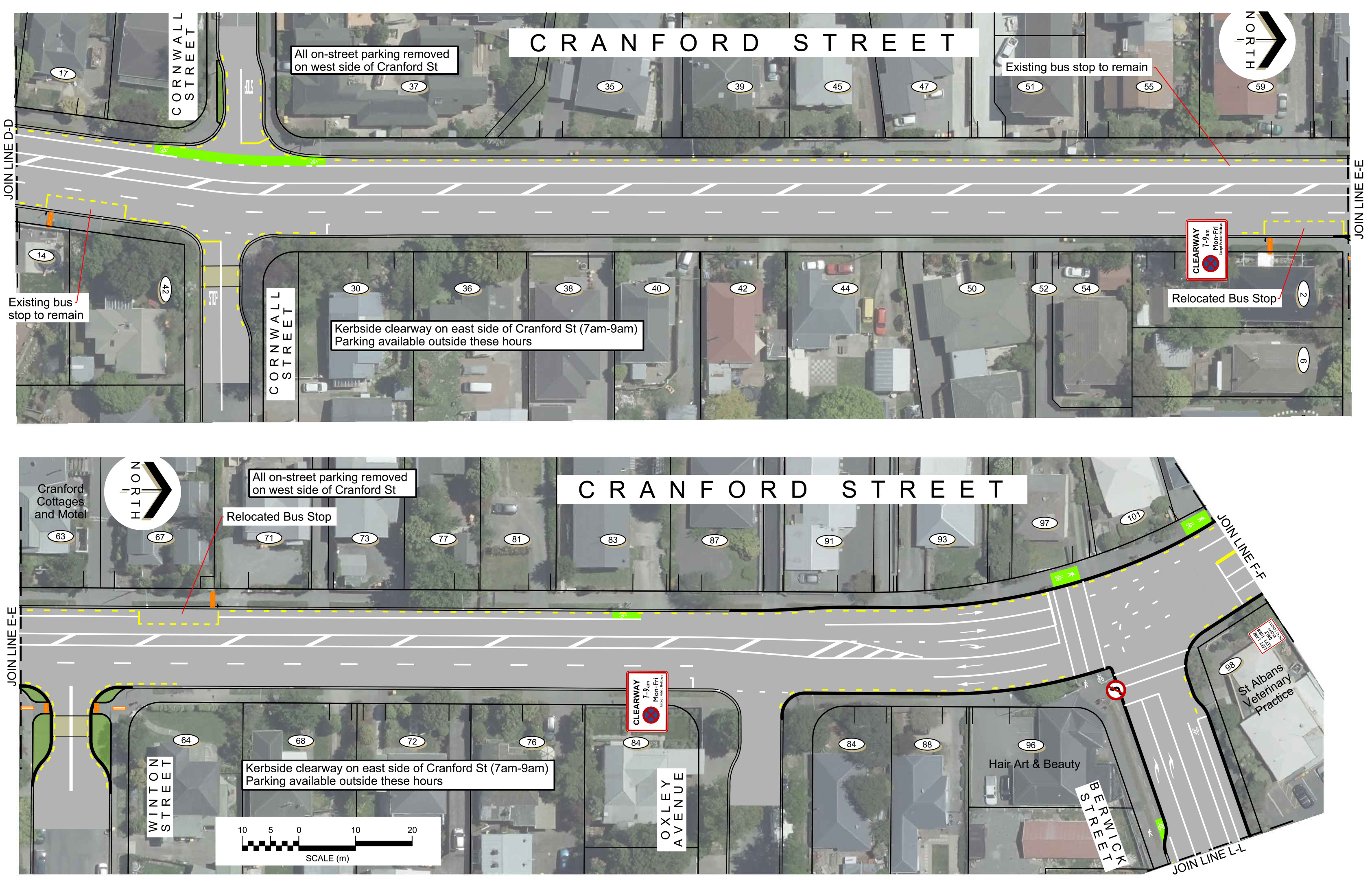
Cranford Street between Innes Road and Berwick Street
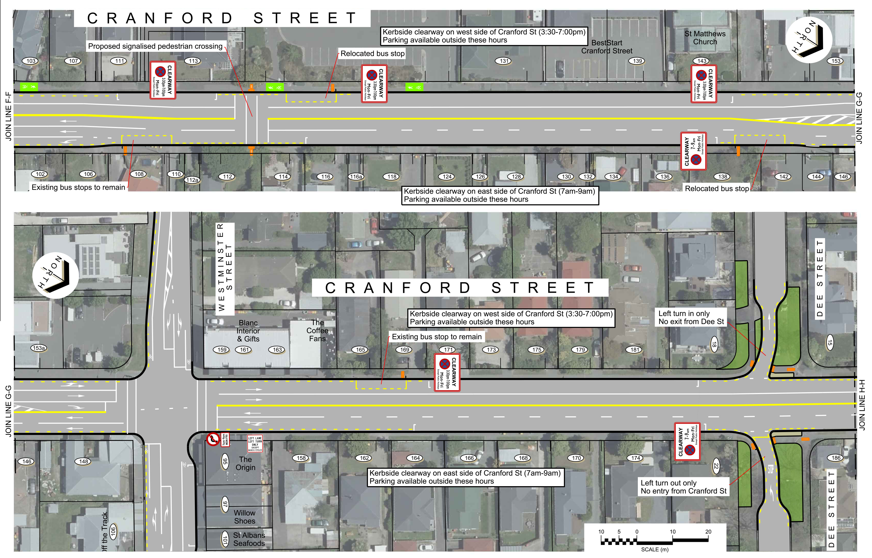
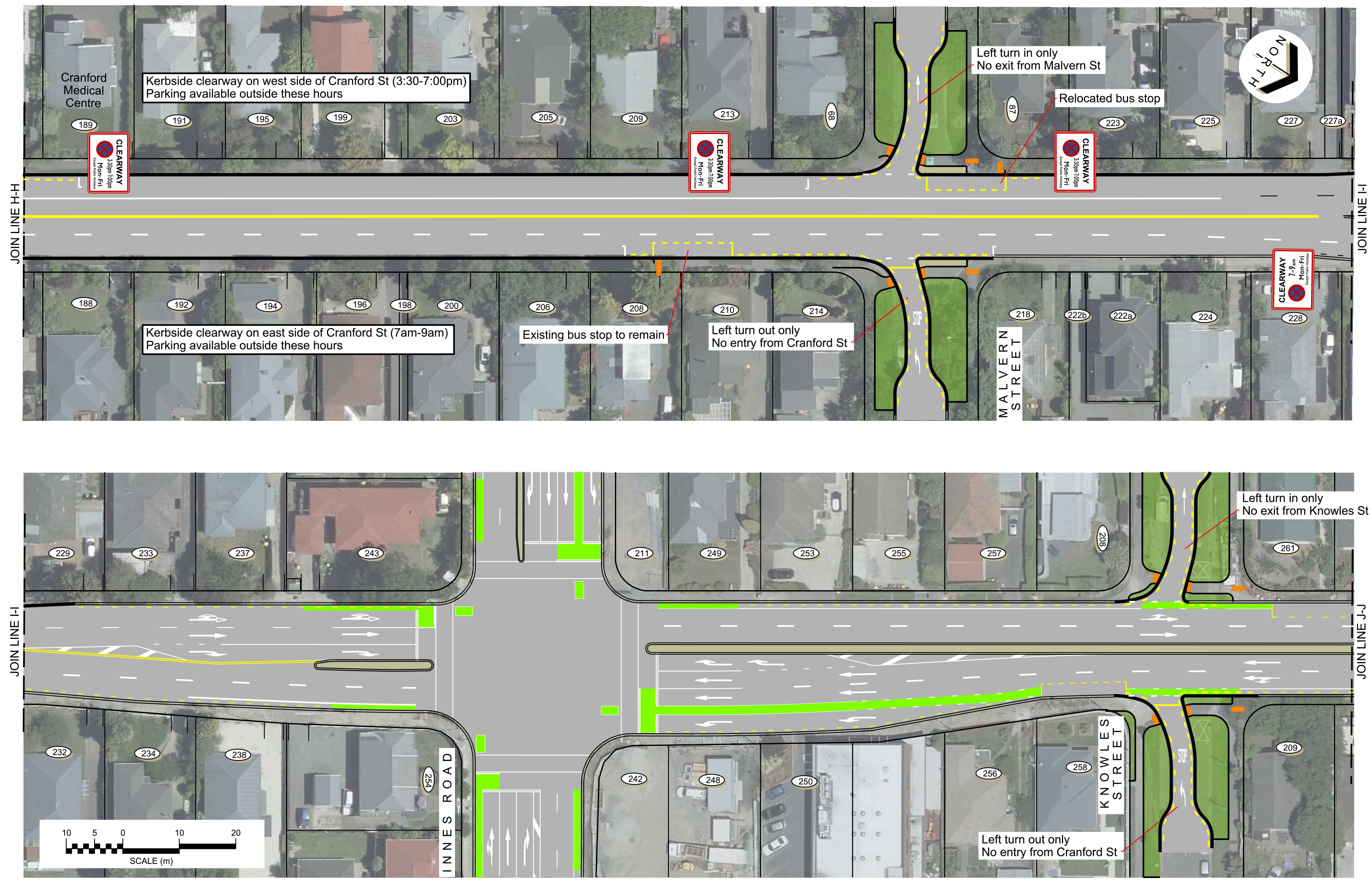
Clearways are proposed along this section of Cranford Street. This means that the kerbside lanes will be used to move vehicles during peak hours and will be available for car parking and cycling at other times.
The southbound clearway will operate between 7am and 9am in the morning and the northbound clearway will operate between 3.30pm and 7pm in the afternoon.
The road will be widened slightly in this section to allow enough space for the clearway lanes to operate as bus lanes or high-occupancy vehicle lanes in the future. It also allows enough space for cyclists and vehicles in the kerbside lane.
A signalised pedestrian crossing will be provided outside English Park to allow better access to St Albans School.

Cranford Street (between Innes Road and Berwick Street) - Morning clearway 7am to 9am

Cranford Street (between Innes Road and Berwick Street) - Afternoon clearway 3.30pm to 7pm
Cranford Street and Sherborne Street between Berwick Street and Bealey Avenue
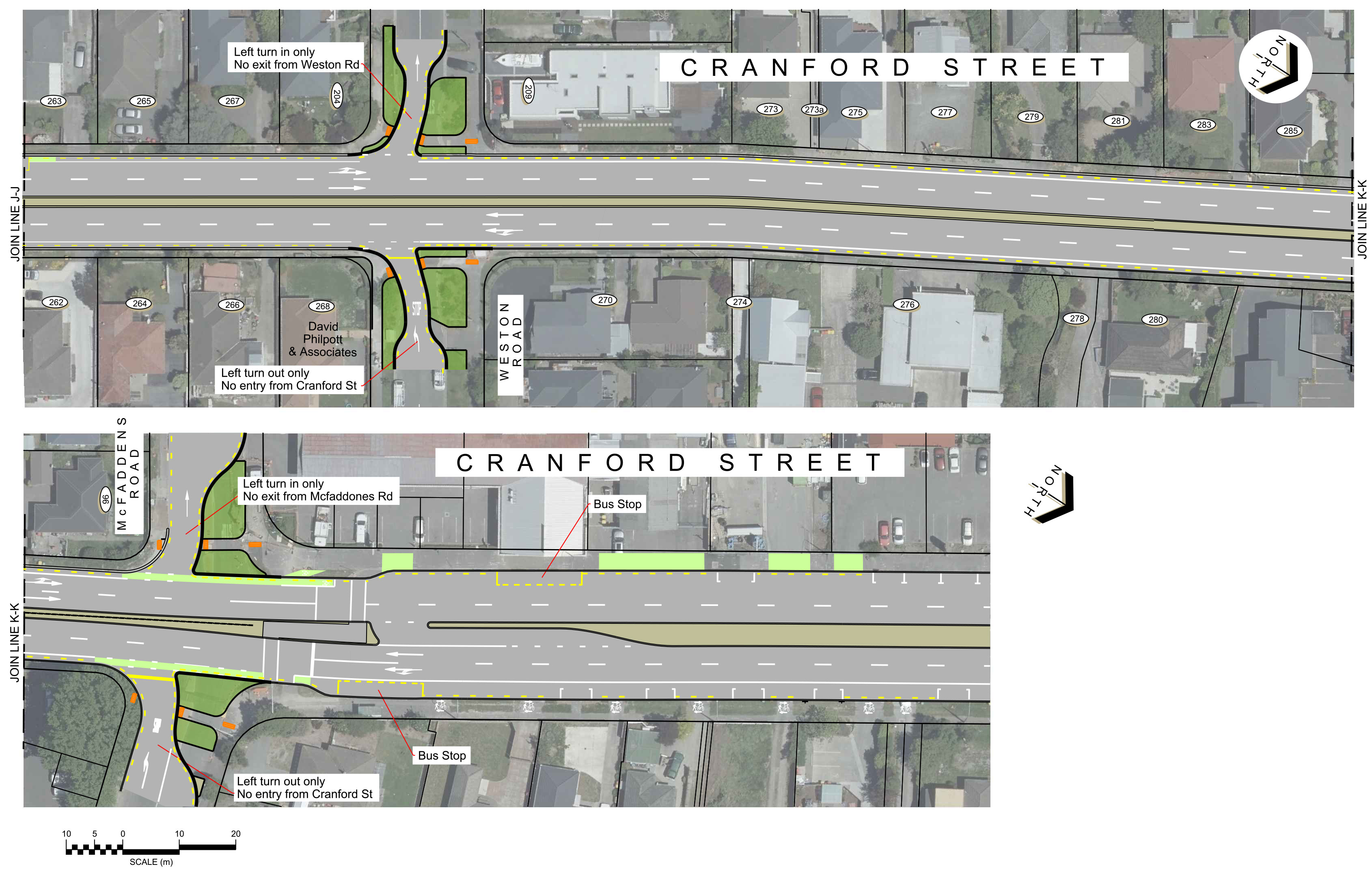
South of Berwick Street the same layout is provided on the southbound side of the road. On the northbound side of the road one vehicle lane is provided along with a cycle lane.
This allows for a painted median along the centre of the road. The painted median will allow residents in the area to turn into their driveways more easily and will provide space for pedestrian crossing islands to make it safer for people to cross the road.
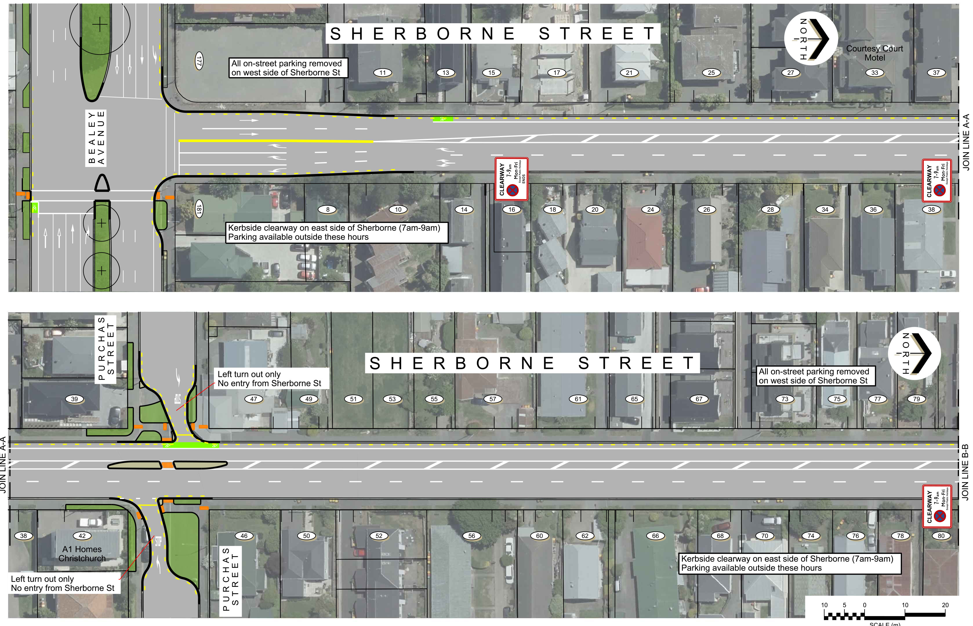
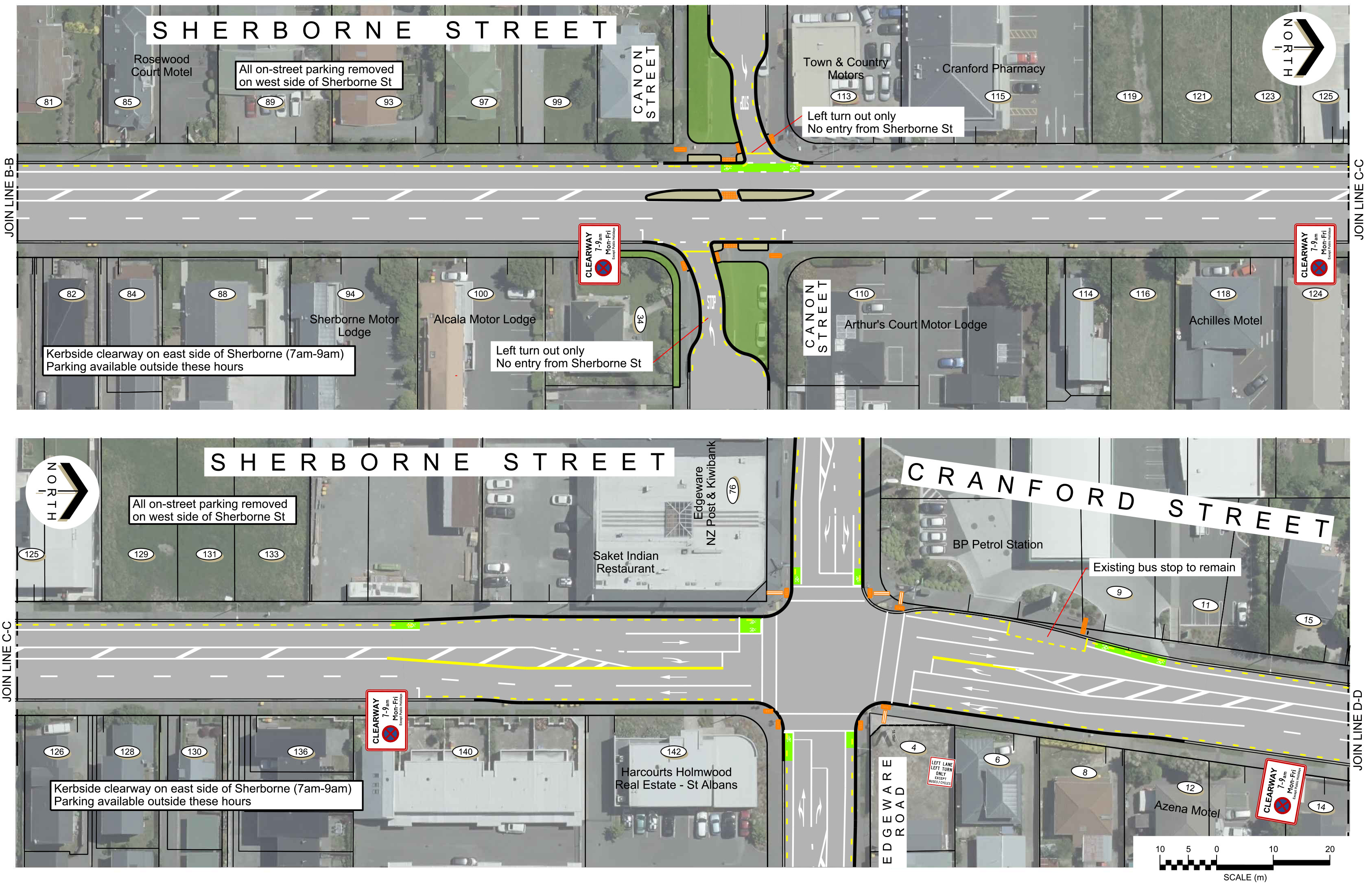
On-street parking is proposed to be removed along the western or northbound side of the road along this section.

Cranford Street/Sherborne Street (between Berwick Street and Bealey Avenue) - Morning clearway 7am to 9am

Cranford Street/Sherborne Street, layout outside of clearway hours. No northbound clearway in this section.
All on-street parking on the west side of Sherborne Street and Cranford Street, between Bealey Avenue and Berwick Street, is proposed to be removed.
The intersections along Cranford Street and Sherborne Street are all proposed to be upgraded to accommodate the new road layout.
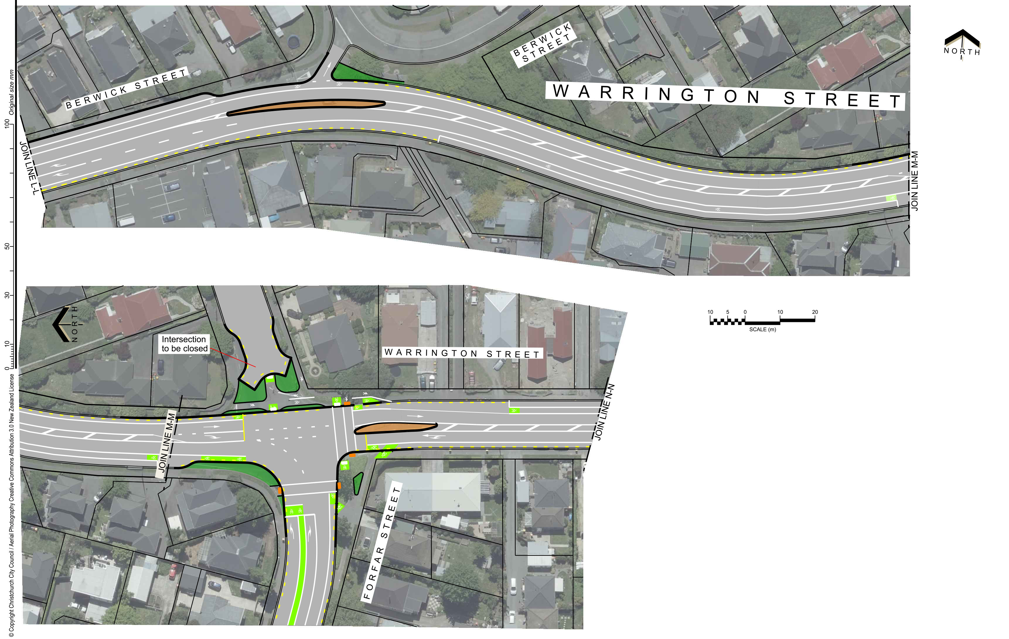
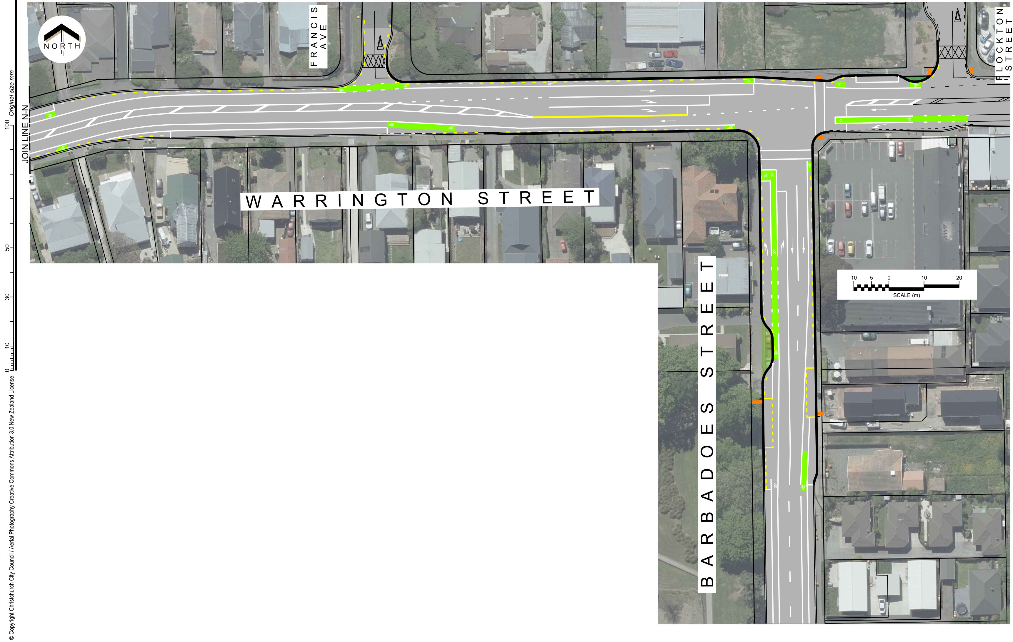
Traffic lights will also be installed at the intersections of Warrington Street and Forfar Street, and Warrington Street and Barbadoes Street, to improve the safety of the intersections. Some parking will be lost around the intersections.
Cranford Street and Westminster Street
A separate right-turning lane will be provided for people turning onto Westminster
Street heading east. The right turn west into Westminster Street will be banned during the morning peak period.
Cranford Street and Berwick Street
The intersection will be widened slightly to allow for two lanes going straight through inboth directions on Cranford Street. Two lanes will be provided turning right from Berwick Street into Cranford Street, but the left turn will be banned. Cycle lanes are provided on Berwick Street and cycle crossing lights onto Cranford Street.
Cranford/Sherborne Street and Edgeware Road
The intersection is widened slightly to allow for the southbound clearway. Cycle lanes are provided on Edgeware Road.
Sherborne Street and Bealey Avenue
There will be two right-turning lanes into Bealey Avenue to help people heading south to connect to Durham Street. A pedestrian crossing phase on the eastern side of Sherborne Street will be added.
Warrington Street and Barbadoes Street
Traffic lights are installed to improve safety at this intersection. This will also make it easier for pedestrians to cross.
Warrington Street and Forfar Street
The roundabout will be replaced by traffic lights, and Forfar Street north of Warrington Street will become a cul-de-sac, making this a ‘t’ intersection. Pedestrian and cycle crossings will be added.

3D image of Warrington Street and Forfar Street
Turning restrictions are proposed at several side roads where they intersect with Cranford Street. This is to prevent short-cutting through the residential neighbourhoods.
Access to the following streets will change to left in only on the west side of Cranford Street and left out only on the east side of Cranford Street
- McFaddens Road
- Knowles Street
- Weston Street
- Malvern Street
- Dee Street
Left out only on both sides of Sherborne Street
- Canon Street
- Purchas Street
Landscaping opportunities
Restricting turning movements at the above intersections creates an opportunity to provide new landscaping areas and at Canon Street and Purchas Street. We will include pedestrian crossing facilities to connect these areas.
The proposed widening of Cranford Street will require the removal of six existing street trees. These landscaped areas will include new trees.
The sketch below shows how planting, seating and other features may be added.

Landscape sketch
Some examples of the landscape opportunities
- Drinking fountain or features
- New seating and paved spaces
- Grass and open space
- Mix of native and exotic plantings
- Opportunities for fruit trees
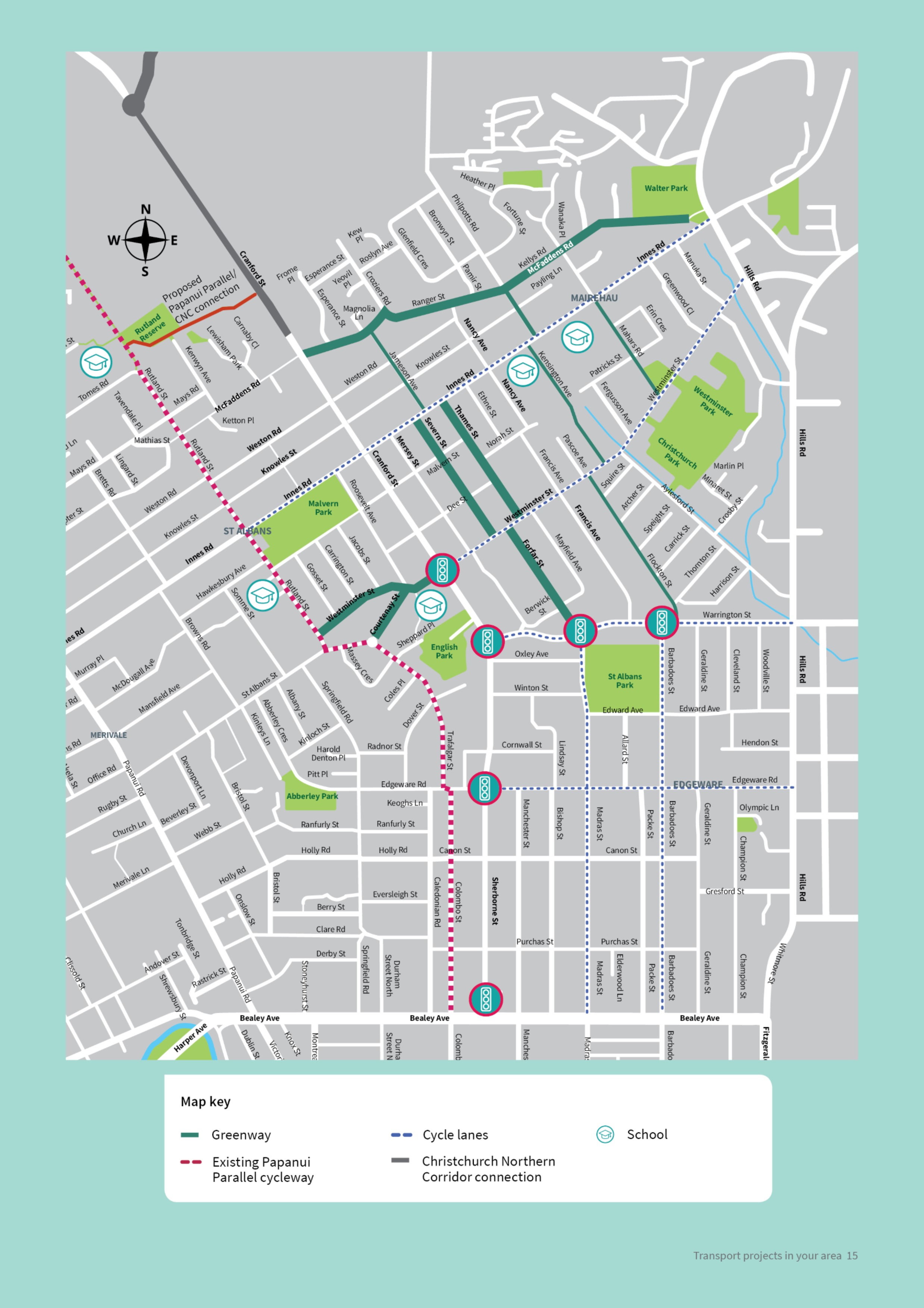
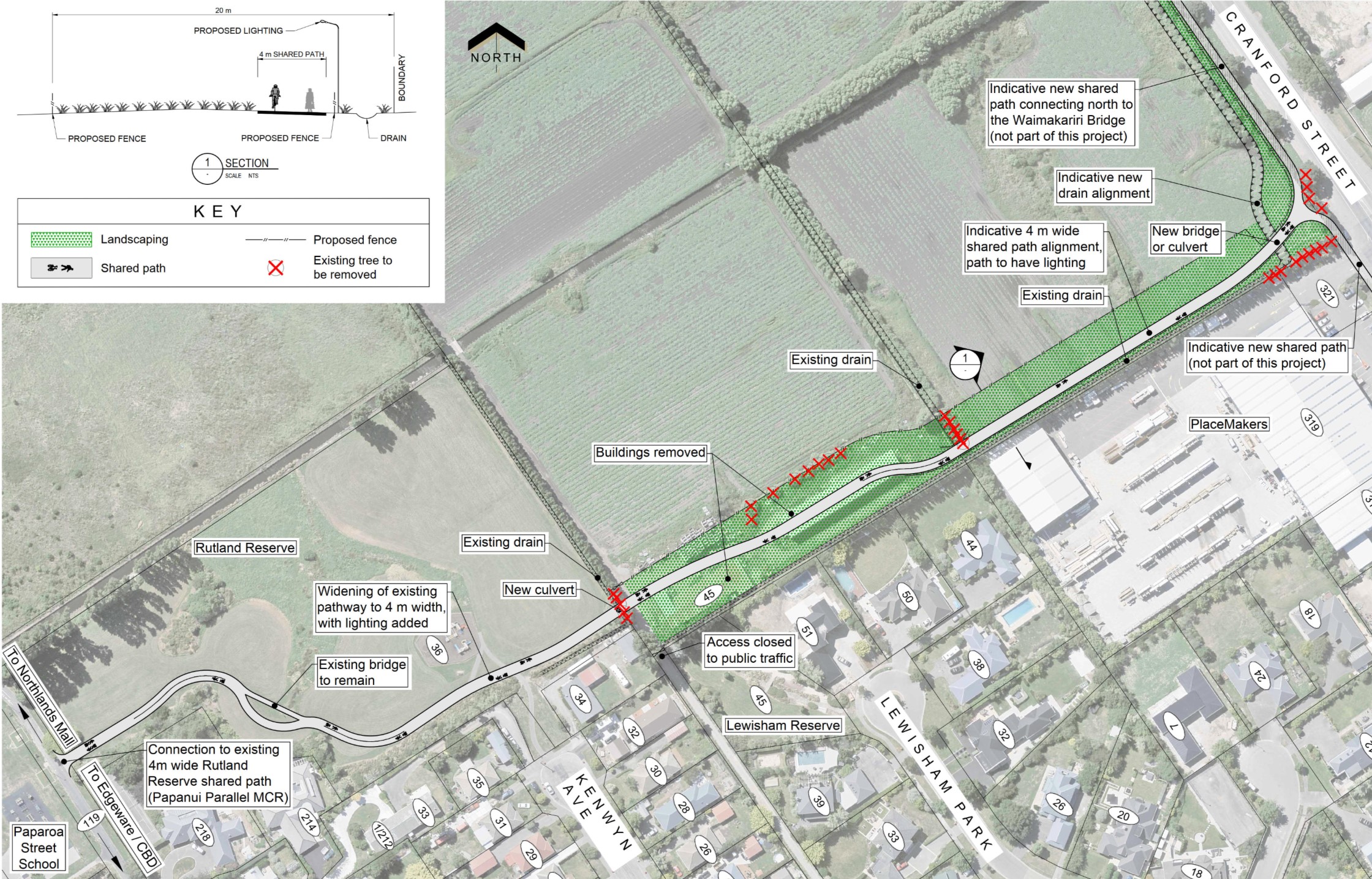
The Christchurch Northern Corridor will have a shared path for pedestrians and cyclists running alongside it. We are proposing a connection to the Papanui Parallel cycleway from that shared path, running alongside Cranford Street before heading west and connecting at the Rutland Reserve.
Download Cycleway overview map [JPG, 783 KB]
Detailed cycle plans [PDF, 15 MB]
We are proposing two north-south routes to the east of Cranford Street. These use a mixture of quiet residential streets where people driving and biking can share the road north of Warrington Street, with painted cycle lanes on Madras Street/Forfar Street and Barbadoes Street south of Warrington Street. These north-south routes feed into the one-way system south of Bealey Avenue.
Painted cycle lanes running east-west are proposed on Innes Road, Westminster Street, Warrington Street, Berwick Street and Edgeware Road. These will connect the north-south routes proposed to the east of Cranford Street to the existing Papanui Parallel cycleway to the west of Cranford Street.
Some parking will be removed to accommodate these cycle lanes.
Neighbourhood greenways
 Mahars Rd (between Westminster St and Innes Rd)
- Kensington Ave
- Thames St
- Severn St
- Jameson Ave
- McFaddens Rd (between Cranford St and Croziers Rd)
- Ranger St
- Kellys Rd
- Philpotts Rd (between Kellys Rd and Innes Rd)
- Flockton St
- Forfar St (between Westminster St and Warrington St)
- Westminster St (west of Cranford St) Courtenay St
Painted cycle lanes
- Innes Rd (between Hills Rd and Rutland St) Westminister St (between Hills Rd and
- Cranford St)
- Berwick St/Warrington St (between Cranford St and Hills Rd)
- Madras St (north of Bealey Ave)
- Forfar St (between Warrington St and Winton St)
- Barbadoes St (north of Bealey Ave)
- Edgeware Rd (between Sherborne St and Hills Rd)

Cycle lane cross sections
Proposed cross section for:
- Innes Road (Hills Road – Thames Street)
- Westminster Street (Kensington Avenue - Cranford Street) • Barbadoes Street (Bealey Avenue - Warrington Street)
- Madras Street (Bealey Avenue - Warrington Street)
- Edgeware Road ( Hills Road - Madras Street)

Proposed cross section for:
- Westminster Street (Hills Road - Kensington Avenue)
- Edgeware Road (Madras Street - Cranford Street)

Proposed cross section for:
- Warrington Street (Barbadoes Street - Cranford Street)

The majority of the parking changes are along Cranford Street and Sherborne Street, as well as where cycle lanes are proposed.
Where clearways are proposed on Cranford Street and Sherborne Street, parking will only be available outside of the clearway times. On the west side of Cranford Street and Sherborne Street between Berwick Street and Bealey Avenue, all on-street parking is removed.
There are also significant parking changes on Berwick Street and Warrington Street where painted cycle lanes and a painted central median are provided.
Detailed parking map [PDF, 7 MB]
Other areas affected by parking changes:
- Innes Road
- Westminster Street
- Edgeware Road
- Madras Street
- Forfar Street
- Barbadoes Street
- McFaddens Road (east of Cranford)
- Weston Road (east of Cranford)
- Weston Road (west of Cranford)
- Knowles Street (east of Cranford)
- Knowles Street (west of Cranford)
- Malvern Street (east of Cranford)
- Malvern Street (west of Cranford)
- Dee Street (east of Cranford)
- Dee Street (west of Cranford)
- Winton Street (east of Cranford)
- Canon Street (east of Sherborne)
- Canon Street (west of Sherborne)
- Purchas Street (east of Sherborne)
- Purchas Street (west of Sherborne)
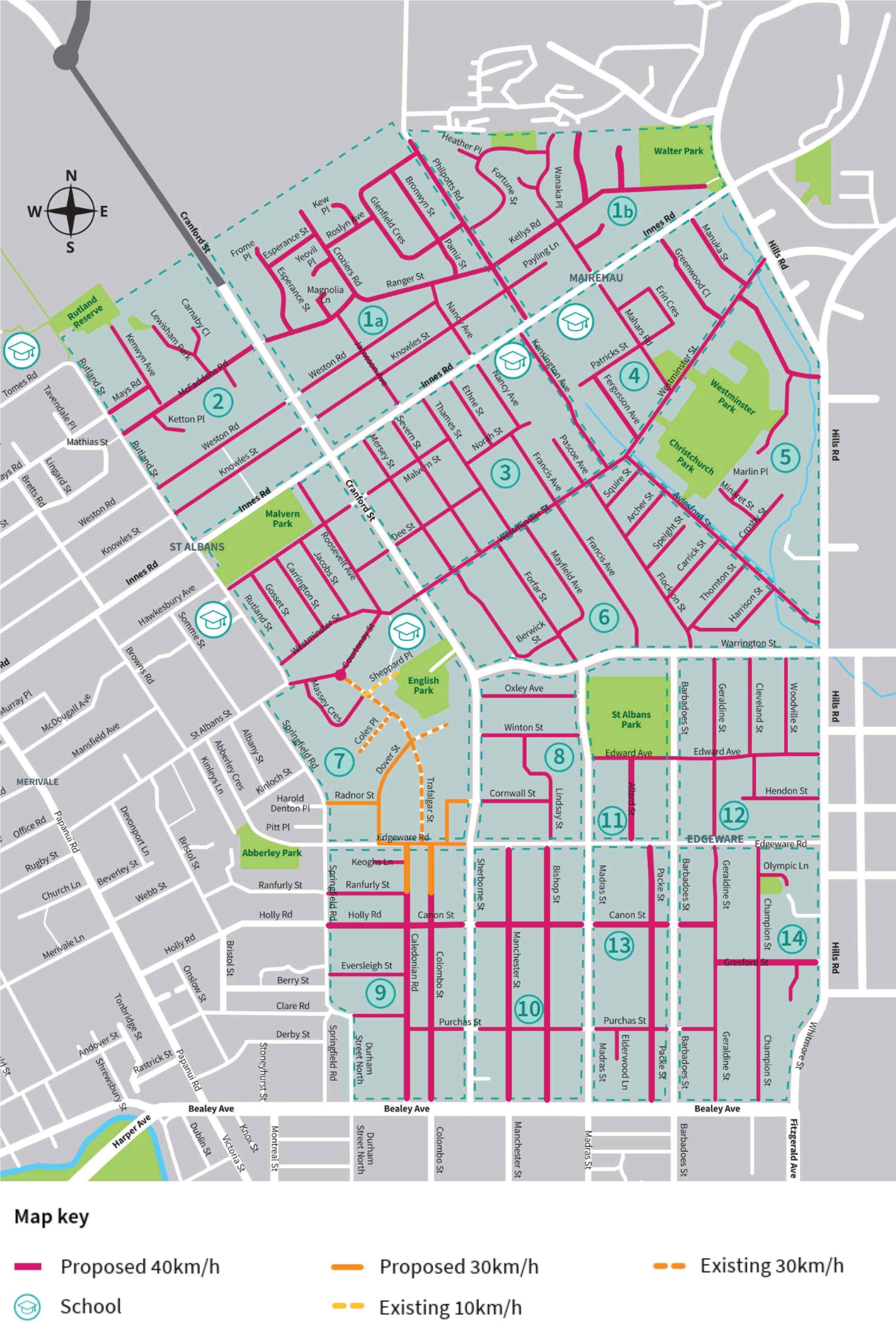
We are proposing a 40km/h zone on residential roads between Rutland Street, Springfield Road and Durham Street North in the west, Hills Road in the east, Walter Park in the north, and Bealey Avenue in the south.
Slower speeds result in fewer crashes and less serious crashes if they do occur. The safe speed zone will make it safer for cyclists and pedestrians and discourage short cutting through residential side streets. The main roads in this area will remain 50km/h. They are Cranford Street, Sherborne Street, Innes Road, Warrington Street, Madras Street, the southern part of Forfar Street, and Barbadoes Street.
Download speed map [JPG, 991 KB]
| Reduced speed zone number and zone boundary | Streets included in the reduced speed zone |
| Zone 1A Cranford St, Innes Rd and Philpotts Rd |
Bronwyn St, Croziers Rd, Esperance St, Frome Pl, Glenfield Cres, Jameson Ave, Kew Pl, Knowles St, Magnolia Ln, Nancy Ave, Pamir St, Philpotts Rd (between Innes Rd and Glenfield Cres), Ranger St, Roslyn Ave, Weston Rd |
| Zone 1B Philpotts Rd, Innes Rd, Diana Isaac Retirement Home |
Cavan Pl, Chilton Dr, Fortune St, Greenfield Pl, Heather Pl, Hawea Pl, Kellys Rd, Payling Ln, Philpotts Rd (btwn Innes Rd and Glenfield Cres), Wanaka Pl |
| Zone 2 Cranford St, Innes Rd, Rutland St |
Carnaby Cl, Kelton Pl, Kenwyn Ave, Knowles St, Lewisham Park, Mays Rd, McFaddens Rd, Weston Rd |
| Zone 3 Cranford St, Westminster St, Kensington Ave, Innes Rd |
Dee St, Ethne St, Francis Ave, Kensington Ave, Malvern St, Mersey St, Nancy Ave, Pascoe Ave, Severn St, Thames St, Westminster St |
| Zone 4 Westminster St, Hills Rd, Kensington Ave, Innes Rd |
Erin Cres, Fergusson, Greenwood Cl, Kensington Ave, Mahars Rd, Manuka St, Patrick St, Westminster St |
| Zone 5 Westminster St, Hills Rd, Aylesford St |
Aylesford St, Crosby St, Fernbrook Pl, Marlin Pl, Minaret St, Westminster St, Whitehall St |
| Zone 6 Aylesford St, Berwick St, Warrington St, Hills Rd, Westminster St |
Archer St, Aylesford St, Berwick St, Carrick St, Flockton St, Forfar St, Francis Ave, Harrison St, Mayfield Ave, Mersey St, Speight St, Squire St, Thornton St, Westminster St |
| Zone 7 Innes Rd, Rutland St, St Albans St, Springfield Rd, Edgeware Rd |
Carrington St, Coles Pl, Cornwall St, Courtney St, Dee St, Gosset St, Jacobs St, Malvern St, Massey Cres, Radnor St, Roosevelt Ave, Trafalgar St, Westminster St |
| Zone 8 Cranford St, Berwick St, Warrington St, Madras St, Forfar St, Edgeware Rd |
Cornwall St, Lindsay St, Oxley Ave, Winton St |
| Zone 9 Edgeware Rd, Sherborne St, Springfield Rd, Durham St Nth, Bealey Ave, Sherborne St |
Caledonian Rd, Canon St, Colombo St, Durham St Nth (between numbers 487 and 511 only), Eversleigh St, Keoghs Ln, Holly Rd, Purchas St, Ranfurly St |
| Zone 10 Edgeware Rd, Madras St, Sherborne St, Bealey Ave |
Bishop St, Canon St, Manchester St, Purchas St |
| Zone 11 Edgeware Rd, Madras St, Barbadoes St, Warrington St |
Allard St, Edward Ave |
| Zone 12 Edgeware Rd, Hills Rd, Barbadoes St, Warrington St |
Cleveland St, Edward Ave, Geraldine St, Hendon St, Woodville St |
| Zone 13 Edgeware Rd, Barbadoes St, Madras St, Bealey Ave |
Canon St, Elderwood Ln, Packe St, Purchas St |
| Zone 14 Edgeware Rd, Hills Rd, Barbadoes St, Whitmore St, Bealey Ave |
Canon St, Champion St, Geraldine St, Gresford St, Purchas St, Olympic Ln, Trist Pl |
| Arterials excluded from the reduced speed zones | Cranford St, Sherborne St, Innes Rd, Berwick St, Warrington St, Rutland St, St Albans St, Madras St, Barbadoes St, Edgeware Rd, Hills Rd, Whitmore St, Springfield Rd, Cul de sacs off Hills Rd, (Spurway Pl, Friel Ln), Dover St, Radnor St, Edgeware Rd (between Dover St and Springfield Rd |
| Edgeware 30km/h zone | Coles Pl Colombo St (between Edgeware Rd and in-line with Ranfurly St), Cornwall St (between Edgeware Rd and Cranford St), Dover St (cul de sac), Edgeware Rd (between Dover St and Sherborne St), Sheppard Pl Trafalgar St |
Traffic calming is proposed on streets that could be impacted by an increase in traffic.
Several ideas have been provided, however the project team are open to suggestions and willing to try new ideas. We will discuss possible solutions with residents at the information sessions or through feedback received.
There are several traffic calming options available and views of the residents of the affected streets will help inform the design process. Designs will be produced after residents have had their say and we will get back in touch with those people who live on these streets in early 2020 to confirm the final option.
| West of Cranford | East of Cranford | |
| Roads to be traffic calmed (to reduce short-cutting) |
|
|
| Roads with Greenways (includes traffic calming) |
|
|
One-way chicane

Two-way chicane

Raised tables


We are proposing to move some bus stops as part of this work:
- Bus stop outside 59 Cranford Street will move to 67 Cranford Street
- Bus stop outside 64 Cranford Street will move to 2 Winton Street (but still on Cranford Street)
- Bus stop outside 213 Cranford Street will move to 87 Malvern Street (but still on Cranford Street)
- Bus stop outside 470 Innes Road will move to 462 and 464 Innes Road
- Bus stop outside 526 Barbadoes Street will move to 516 Barbadoes Street
- Bus stop outside 135 Edgeware Road will move to 151 Edgeware Road
- Bus stop outside 122 Edgeware Road will move to 132 Edgeware Road
- Bus stop outside 182 Edgeware Road is removed, as there is a bus stop close byon Barbadoes Street
Download consultation booklet [PDF, 6.2 MB]

