Draft QEII Park Master Plan

We are developing a master plan to help determine the future of Queen Elizabeth II Park and how it will be used. The goal is to make sure the environment and buildings are connected and the area works well for the community.

Project status: Decision made
Open for feedback: 12 October 2018 to 13 December 2018

Share this


Consultation has now closed

Consultation on the Draft QEII Park Master Plan has now closed. Hearings started on 21 January and the panel's recommendations will go to Council for a final decision in April or May. Once available, you can find minutes from the Hearings Panel here. You can read full submissions [PDF, 311 KB] and staff comments, and the analysis of submissions [PDF, 17 KB].


QEII Park: where together we learn, get active and have fun


Aerial view QEIIWe have developed a draft master plan that achieves this vision. QEII Park is a significant and treasured part of the community, which considers the values of recreation, landscape, culture, heritage and ecology to all have a place in the development of the park. 

While some features are already set in stone – including the new $38.6 million Taiora: QEII Recreation and Sport Centre, an area leased to the Christchurch School of Gymnastics (CSG), and the combined Shirley Boys’ High School and Avonside Girls’ High School campus currently being built – a vision for the park’s remaining 36.63 hectares can now be created.

$3.4 million raised from the sale of land to the Ministry of Education in 2016 for the new school campus has been set aside for the initial development and implementation of the plan.

Community feedback

Earlier this year we asked the community what they value about QEII Park. Lots of people told us that we needed to develop a plan that has something for people of all ages, is focused on leisure and recreation, and makes the most of the green and open spaces and the natural environment.

We also heard lots of ideas about what activities could happen in the park, so we know our plan needs to include spaces where people can:

  • Be physically active, without any cost (walking and cycling tracks, and exercise and play equipment)
  • Relax (BBQ and picnic areas, and space for community events)
  • Take part in commercial sports
  • Take part in free sports using dedicated community sports areas

We also know we need to get the basics right with good facilities, such as car parking, toilets and lighting.

Our approach

QEII Park landProposed actions were developed following community engagement and assessment of:

  • The physical environment
  • Land condition
  • Sport and play networks within the wider Christchurch area
  • Operational requirements.

Planning the park as a whole means that a variety of activities can work together to meet the needs of the surrounding community. 

You can find out more by reading the full Draft Master Plan [PDF, 5.6 MB].

Talk to the team

Come along to one of our drop-in sessions for an informal chat about the master plan and join us for a guided tour. We’ll show you some of the areas we’re excited about and discuss your ideas as we walk around the park.

Taiora: QEII Recreation and Sports Centre

Tuesday 23 October

3pm–5pm

Tours leave from the foyer area at 3.30pm and 4.15pm

Saturday 3 November

11am–1pm

Tours leave from the foyer area at 11.30am and 12.15pm

Wednesday 28 November

4.30pm–6.30pm

Tours leave from the foyer area at 5.00pm and 5.45pm

Tours take approximately 45 minutes and will cover most of the park area. Please wear sturdy shoes, especially if wet.

What we are planning to do

We propose that the following projects happen in the first stage of the master plan, which will take up to three years to complete. Staging is based on current priorities and opportunities to get things done efficiently. We also considered projects already in development, community feedback and providing infrastructure to support activities.

Cost estimates are indicative only. This uses all of the $3.4 million allocated at this stage. Future work (see project costs in the full Draft Master Plan (insert link) ) would require funds to be allocated through the Council’s Long Term Plan (LTP).

Completed in year 1

Renew car park near existing sports fields

Allocated in current LTP

Upgrade fitness track

$50,000

Install new fitness track exercise equipment (10 stations)

$110,000

Internal paths - phase 1

$150,000

Remove existing perimeter fence and replace with new bollard-style. Enhance pedestrian and cycle entrances, including plants and signs

$200,000

Maintain existing and plant new trees and shrubs

$150,000

18 hole disc golf course

No Council cost

Completed in year 2–3            

New changing rooms and public toilets - includes landscaping

$1,000,000

Re-position sports field - includes mounding and lighting

$600,000

Internal paths - phase 2

$200,000

Install western car park - phase 1

$400,000

Remove earthquake-damaged buildings

Allocated in current LTP

Install playground - stage 1

$200,000

Install seats, picnic tables, bike stands

$50,000

Stormwater basin

$350,000

Getting into and around the site

Child cycling in park

Appropriate and safe access into and within the park, for all modes of transportation, is a priority for the park’s development. Current pedestrian and cycle.

Suitable car parking was a key concern raised by the community. We have assessed parking requirements for users of the park now and in the future. Sufficient car parking will be provided to meet anticipated demand, taking advantage of existing hard surface areas.access in some areas of the park is constricted and internal paths are disjointed after the demolition of buildings post-earthquake.

The master plan is not proposing to convert areas that are currently grass to additional car parking. Measures such as time limits for parking may be introduced, to prevent all-day parking by people who aren’t using the park.


Issue

Proposed actions  

Poor pedestrian and cycle access into park

Formalise nine pedestrian and cycle entrances. Entrances to be signposted, enhanced for maximum visibility and connected to the internal path network. 

No all-weather pedestrian and cycle access

Creation of a primary shared path around and through the park linked to pedestrian and cycle entrances, secondary grit paths and vehicle parking areas.

Poor pedestrian and cycle linkage with surrounding area

Include directional signage to Travis Wetland from north west pedestrian and cycle entrances. Additional signage throughout park, where appropriate.

Poor vehicle, pedestrian and cycle entrance to community centre

Replace existing fences with bollards that are easier to get through. Enhance entrance from Ascot Avenue by clearing vegetation. Entrance to include signage.

Capacity of vehicle entrances

Upgrade Travis Road entrance as required to reduce the potential for associated congestion.

Insufficient provision of car parking for current and future park users

Renew and develop existing vehicle parking area for park users. Mai

ntain use of existing vehicle entrances and access roads. Future-proof park capacity by allocating space for expansion of car park.

No cycle parking for park users

Provide bike stands at key locations throughout park.

Things we can do here

QEII Park has changed considerably following the earthquakes. Major facilities have been demolished and new facilities have been developed, while other areas have been left untouched. There are still barriers left over from pre-earthquake activities, which impact on connectivity and how the park is used. Enhancing the recreation uses of the park is a priority of the master plan.

Land quality is a major constraint when considering what activities can take place in the park. During the earthquakes, the land and buildings were impacted by lateral spread and liquefaction. Post-earthquake surface levels show that QEII Park is lower towards the west (Frosts Road). The western side of the site is in a Flood Management Area (FMA) and an overlay of Fixed Minimum Floor Level in a portion of the FMA.

Sign board located at Taiora QEII

All future structures on the park will need to consider ground improvement work.

The master plan works within the limitations of the land by allowing the lower-lying western side of the site to revert back to natural wetland conditions. The proposed large area of indigenous forest and native wetland plantings will require minimal change to the land levels and will work with natural processes rather than trying to control them.

The previous golf facility was a key subject raised by the community. Prior to the 2010 and 2011 earthquakes, QEII Park was home to the Ascot Golf Course and Golf Driving Range. The golf course, built in 1967, was a unique facility which provided an 18-hole, par-three course. The driving range was a later addition to the site’s south west corner. Community feedback was mixed, with people both in support of and opposed to the reinstatement of a golf course or driving range in the park.

Factoring in the earthquake damage sustained to QEII Park, the large amount of golf courses already in east Christchurch and the reduction of the park’s area if a golf course were put on it, the master plan does not reinstate golf back into the park.

Use and allocation of sport fields was another subject raised by the community. QEII Park currently has two senior sport fields and a lit training field which are allocated to various sporting codes through the sports field allocation process. These sports fields are managed as flexible but bookable spaces and the master plan proposes no change to the current process. As the Sports Parks Network Plan is developed, a need has been identified for a selection of large parks across the city with multiple fields capable of catering for a variety of sports as required. With the addition of an extra field, QEII becomes an ideal venue able meet these requirements in the north east of the city. An additional multi-use sport field and supporting change facilities have been included in the master plan.

Issue

Proposed actions  

Out-dated fitness station equipment

Upgrade fitness stations on circular trail around sports fields.

Limited seating and picnic tables within the park

Upgrade and provide additional seating and picnic tables throughout park.

Limited play facilities within park

Development of new play facilities including playground, basketball court, disc golf course and adventure nature trail.

Existing petanque courts closed off from park users

Remove fencing and vegetation to integrate petanque courts with park.

Demand for additional multi-use sport field

Provision for development of a new lit multi-use sport field.

Existing lit training sports field area reduced by new gymnastics building

Reposition existing lit training field to a north/south orientation.

No events space in park

Incorporate event features when repositioning existing lit training field.

No seating for sport spectators

Develop a grass mound around the lit training field/event space.

Buildings and structures

QEII Park offers community facilities including Taiora: QEII Recreation and Sports Centre, Ascot Community Centre and Christchurch School of Gymnastics. We know from public feedback that many people do not want to see additional buildings in the park. However, the post-earthquake demolition of buildings has left the park without some basic services. New public toilets and change facilities are proposed as part of the master plan.

Issue

Proposed actions  

No public toilets in the park

Incorporate public toilets into the sport change facility at the centre of the park and into the Ascot Community Centre near the local play space.

No sports changing rooms in the park

Build a changing block to service existing and proposed sports fields.

Future expansion of Taiora: QEII Recreation and Sports Centre

Future-proof Taiora: QEII Recreation and Sports Centre by allocating space for future expansion. 

Demolition of remaining buildings

Complete the demolition of remaining earthquake damaged buildings including; pump house, sand shed, greenkeeper’s workshop and main park workshop.

Enhancement of Ascot Community Centre

Enhancement of Ascot Community Centre building, including renewal of fixtures and fittings and assessment of external layout to provide more connectivity to the park.

Hydroslide at QEII Park

Plants, trees, water and wildlife

Trees and other vegetation was a key subject raised by the community. QEII Park has a mix of native and exotic trees with 126 species across the site. Because of the planting landscaping done by people over the years, vegetation cover in the park today is very different from its natural state, and ecological values have been degraded.

QEII Park’s shelter belts – rows of trees planted to section off areas of the park – are in poor health, and have an impact on visibility and connectivity. Individual trees vary in size and type and include trees planted for the 1974 commonwealth games at the main entrance to the site.

The master plan proposes to selectively remove shelter belts and individual trees that have been identified as in very poor condition, and complete maintenance on trees that are in poor condition. This is illustrated in the Tree Plan. Additional individual trees are proposed, as well as an area of native forest plantings, which will significantly increase the canopy cover of all trees in the park.

Although located next to Travis Wetland, a significant conservation area, wildlife within QEII Park is very limited. Increasing vegetation cover will provide improved habitat and enhance the park’s biodiversity.

Issue

Proposed actions     

Lack of prominence of 1974 commonwealth games memorial trees

Enhance surrounding area by re-establishing memorial plaques and seating areas.

Ageing shelter belts obstructing entry into and around the park

Remove sections of shelter belts and replace them with individual tree planting.

Quality of trees

Complete pruning to specimen trees, as required.

Limited biodiversity within park

Enhance biodiversity by planting native species on the western side of the park. Make an application to the Queen’s Commonwealth Canopy programme for the western area of QEII Park (2.9ha).

Lack of vegetation near new paths and carparks

Enhance with the inclusion of specimen tree planting. 

Stagnant ponds

Link up existing ponds with proposed water areas to create flow.

How the park looks and feels

With a strong sense of local ownership, QEII Park should make all users of the park and its facilities feel safe and welcome. The area has a rich history and we have an opportunity to create a park that tells its story and how it is connected to the surrounding area as the user moves around the site. The master plan proposes to enhance the visual amenities of QEII Park, while applying crime prevention though environmental design (CPTED).

Issue                                   

Proposed actions  

Lack of site history stories

Integrate Ngāi Tahu / Ngāi Tūāhuriri stories in the implementation of the master plan identifying what makes QEII’ unique. Work with the community to co-create interpretation for QEII Park.

Out of date / lack of park signage

Develop a park-wide signage plan. Signs to be updated in accordance with Christchurch City Council brand guidelines.

Closed off spaces and lack of view

Improve views into and through the park through removal of selected vegetation.

Lighting within the park

Provide lighting in carparks and on the circular fitness track and main commuting paths.

Mixed styles of park furniture and structures

Develop an outdoor furniture list for QEII Park, consistent with furniture style around Taiora: QEII Recreation and Sports Centre.

CPTED issues near Ascot Community Centre

Remove fence and vegetation between park and community centre to open up and integrate the two spaces. Develop BBQ and picnic area behind community centre.

CPTED issues and prominence of the current Christchurch School of Gymnastics building

Remove shelter belt to the west of the building, improving line-of-sight from the park. Plant specimen trees around the building, to soften the view from main vehicle entrance.

Perimeter fencing limiting access

Remove existing perimeter fencing and replace with bollards. Include signage to deter motorbikes.

To zoom in on the image, click on it to open and then hold Ctrl and tap + (and Ctrl and - to zoom out again)

Or you might like to download the PDF versions below:

QEII Park concept plan PDF [PDF, 3.8 MB]

QEII Park staging plan PDF [PDF, 2.6 MB]

QEII Park playground plan PDF [PDF, 643 KB]

QEII Park adventure trail plan PDF [PDF, 2.9 MB] 

Background

Te Ngāi Tūāhuriri Rūnanga holds mana whenua and are kaitiaki of the takiwā where Queen Elizabeth II Park is located. Areas of significance to Ngāi Tūāhuriri in the vicinity to the park include Ōruapaeroa, Ōtākaro, Te Ihutai, Waitākiri and Waikākāriki.

The park is adjacent to Ōruapaeroa (Travis Wetland), a place where freshwater swamps and occasional inundation by the sea, through Ōtākaro created a rich marine habitat and environment. As a result this site became a significant kainga nohoanga and mahinga kai site to Ngāi Tūāhuriri for many generations prior to urbanisation of the area.

Recreation and leisure has been a consistent theme throughout the evolution of Queen Elizabeth II (QEII) Park. As early as 1884, the site has been host to various local, national and international events, as well as providing a place of recreation and leisure to its surrounding community. The 36.63 hectare park was purchased by Christchurch City Council in 1963 and named Queen Elizabeth II Park following the royal visit later that year.

Over the years, the park has been a key facility for both Christchurch and New Zealand. With facilities built prior to Christchurch hosting the 1974 Commonwealth Games, QEII Park became a world-class sporting venue and the first in the world to bring athletic and aquatic facilities into a single complex. 

QEII Park is in a phase of transition. In 2010 and 2011 the park was damaged in the Canterbury earthquakes, with its major facilities beyond repair. Many of these facilities have since been demolished and rebuilt in other locations throughout Christchurch, shifting QEII Park from a park that hosted metropolitan facilities to one that’s focused on local and regional needs.

Community interest in QEII Park remains high, and the master plan is key to providing a clear 10 year outlook that will guide the future development of the park. 

Why a master plan


example Field QEII Park
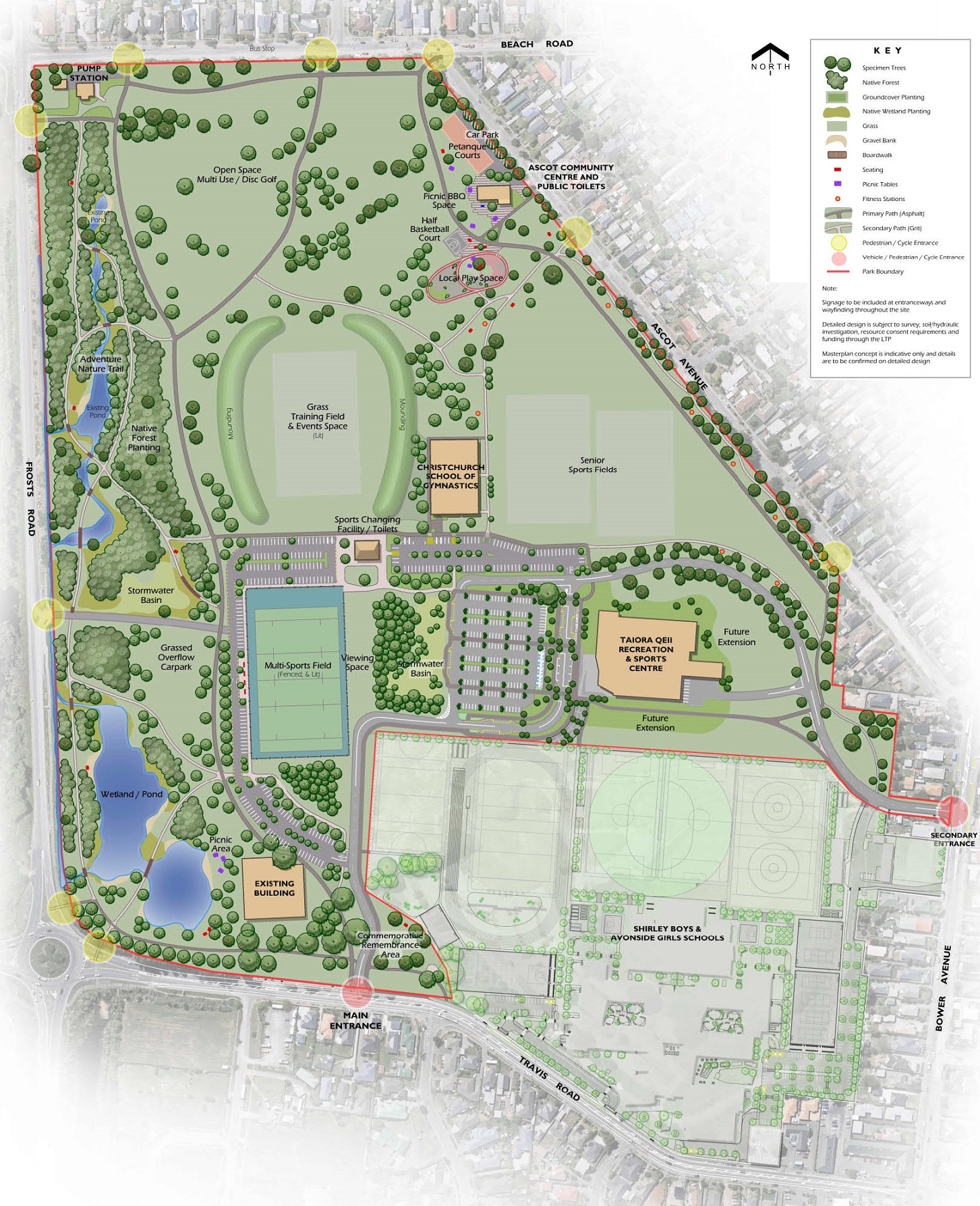
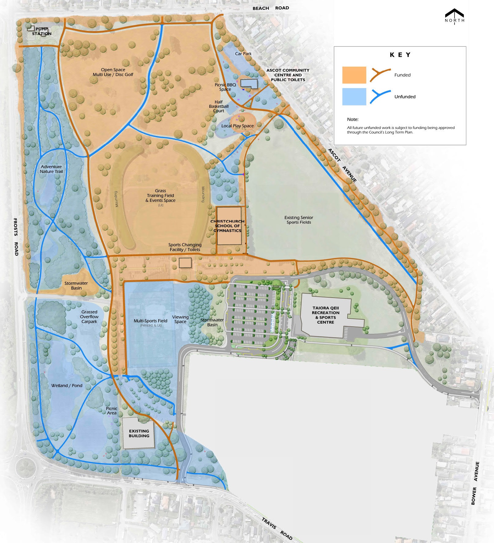
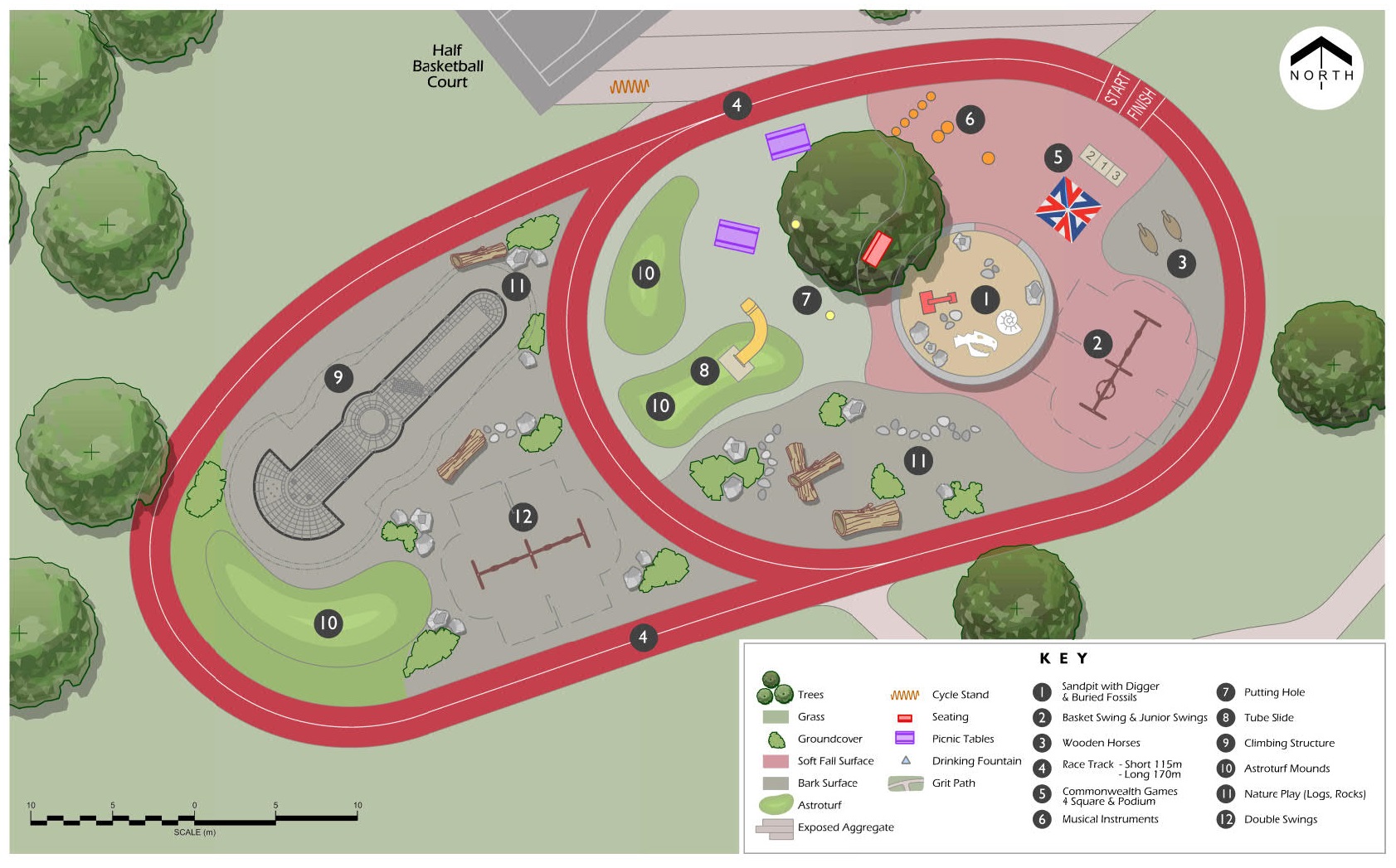
The purpose of the master plan is to guide and advocate for the ongoing development of QEII Park by establishing a long term vision, identifying issues and opportunities and setting prioritised actions for future development.

After the demolition of QEII Park’s earthquake-damaged buildings, a number of key decisions were made, which have influenced the future development of the park. Ngā Puna Wai was confirmed as the major metropolitan sports hub for Christchurch, becoming the regional home for four sporting codes including athletics, while the Metro Sports Facility – Taiwhanga Rehia was confirmed as Christchurch’s national and international aquatic facility.

The request to prepare a master plan for the park came in 2016, when the Council decided to sell approximately 11.5 hectares of QEII Park to the Ministry of Education for the development of Avonside Girls’ High School and Shirley Boys’ High School and the proceeds from the sale of the land were allocated for the development and implementation of a master plan for QEII Park.

History of the park

In its earliest recorded history, the western section of QEII Park was part of the extensive wetland, Ōruapaeroa(external link), which was an important kainga and site of mahinga kai for local Ngāi Tahu hapū and whānau.

Over the years QEII Park has had a rich and diverse history. The park has been home to a variety of activities that have connected people on a local, national and international level. Throughout its evolution, QEII Park has remained a significant part of the community.

In 1884, the New Brighton Trotting Club held its first meet. The club was active there until 1941, when the park became home to local military during World War II.

In 1963, the grounds were purchased by Christchurch City Council and renamed Queen Elizabeth II Park in honour of that year’s royal visit.

AthleteCommonwealth Logo

In 1967, Ascot Golf Course was constructed on the western section of the park.

In 1974, QEII Park became the main venue for the 10th British Commonwealth Games – the first of many big events to be hosted by the city at QEII Park. Over the years, QEII Park hosted local, national and international events, including the International Paralympic World Swimming Championships, the FIFA U17 Soccer World Championship, New Zealand Track and Field Championships, Weet-Bix triathlons and major concerts.

In 1983, QEII Fun Park opened, with the golf driving range opening later in 1990.

Earthquake damaged land

In 2010 and 2011, the park and the facilities on it were significantly damaged in the Christchurch earthquakes. The aquatic centre, stadium, sports house, preschool, driving range and golf course were all closed following the February 2011 earthquake. Detailed post-earthquake analysis was completed throughout the site and after careful investigation it was found that the facilities at QEII Park were beyond repair. Demolition of both the stadium and pool complex began in August 2012. 

In 2016 Christchurch City Council sold 11.5 hectares of QEII Park to the Ministry of Education for the development of the new Avonside Girls’ High School and Shirley Boys’ High School campus. This highlighted the need to develop a master plan for the whole site. In 2017, Christchurch City Council approved the lease of land at QEII Park, to the Christchurch School of Gymnastics.

A significant milestone for the park came in 2018, when the new Taiora: QEII Recreation and Sports Centre was opened. 

Physical description of the park

Topography and soils

Example field at QEII

Over the years, the site’s landscape has undergone significant changes, with local drains dug and sand dunes removed to flatten out the natural back dune system.

Canterbury soil information maps identify the different kinds of soil on QEII Park, showing the legacy of the back dune system. The eastern part of the park is made up of Kairaki deep sandy loam (well drained) soil, and most of the rest of the site is Aranui deep sandy loam (poorly drained). Small areas next to Frosts Road are Waimariri deep peat over silty loam, which is a very poorly drained soil.

Historically, periodic flooding by the Waimakariri and Styx rivers would have created alluvial deposits over a sandy substratum.

Waterways

A number of artificial drains within the site have been constructed to help drain low lying areas.

Preece Drain runs along the length of the western boundary next to Frosts Road and is identified as an environmental asset waterway. It is piped under Travis Road and discharges into the Kate Sheppard waterway, which in turn discharges to the Avon River downstream of the Anzac Drive intersection.

Climate

Christchurch has a temperate climate with mild summers and cool winters and a moderate rainfall.

Due to its location, QEII Park is prone to the predominant easterly wind from the sea, which can reduce the overall temperature. Warm, dry northwest winds are also a regular occurrence and have the potential to cause damage to trees and shelterbelts.

Frosts are common during the winter months. However, the park’s closeness to the Pacific Ocean reduces the likelihood of frost causing damage.

Ecological Values

The site is identified as a coastal plains ecosystem in the Otautahi Indigenous Ecosystems Map, and would have once included trees such as Ngaio (Myoporum laetum) Akeake (Dodonaea viscosa) and Manuka (Leptospermum scoparium) on the eastern side and swamp species such as Oioi/wire rush (Apodasmia similis) and New Zealand flax/harakeke (Phormium tenax) on the western side (refer to Lucas maps for the full list of species).

These vegetation communities are also evident on the ‘Black Maps’ which clearly divide the site, with manuka and swamp to the west and scrub and fern land to the east.

Today, most of the site is covered in exotic grass species, and most of the tree species are exotic too. Trees include single specimens and shelterbelt plantings, as well as trees within shrub borders and understory plantings, with a few native shrub species mixed in.

Over the years, trees have been planted and removed as the park has transitioned through various developments and uses. Photographs dating back to the 1920s show a variety of tree groupings, with more recent photos showing that they had been removed over time.

Most of the existing established trees appear to have been planted from the 1930s to the 1990s, with the majority of these planted since the late 1970s.

During our most recent tree survey in 2018, we counted approximately 998 individual trees, including 857 trees within the park boundary and 141 trees on the road corridor immediately alongside to the park. We also counted 38 shelter groups with approximately 831 trees within the park.

Like all living organisms, trees go through growth and decline cycles. While the majority of trees were found to be healthy and structurally sound, a number were found to be in poor condition, and in need of maintenance or removal.

Buildings and facilities

Facility Example QEII
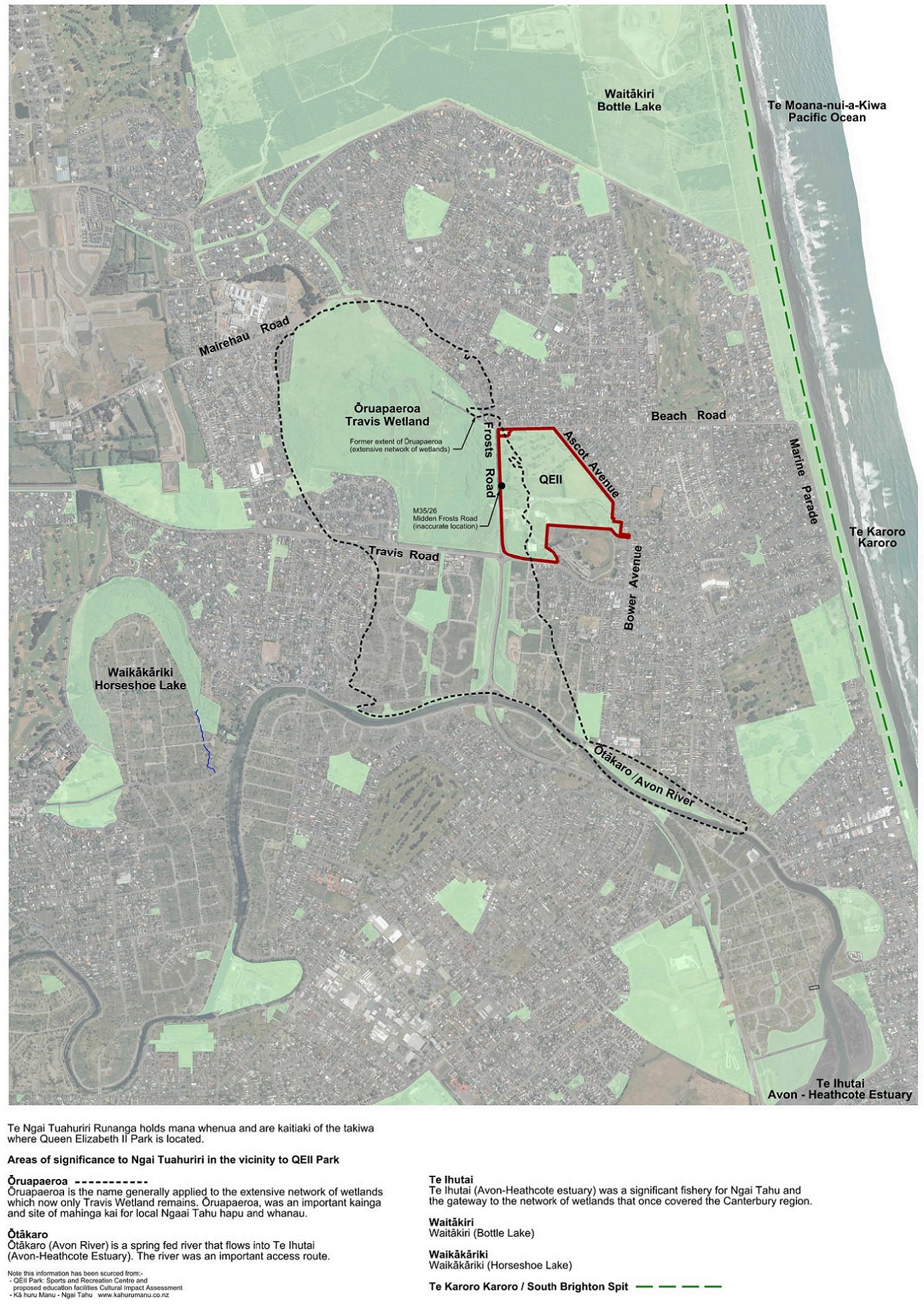
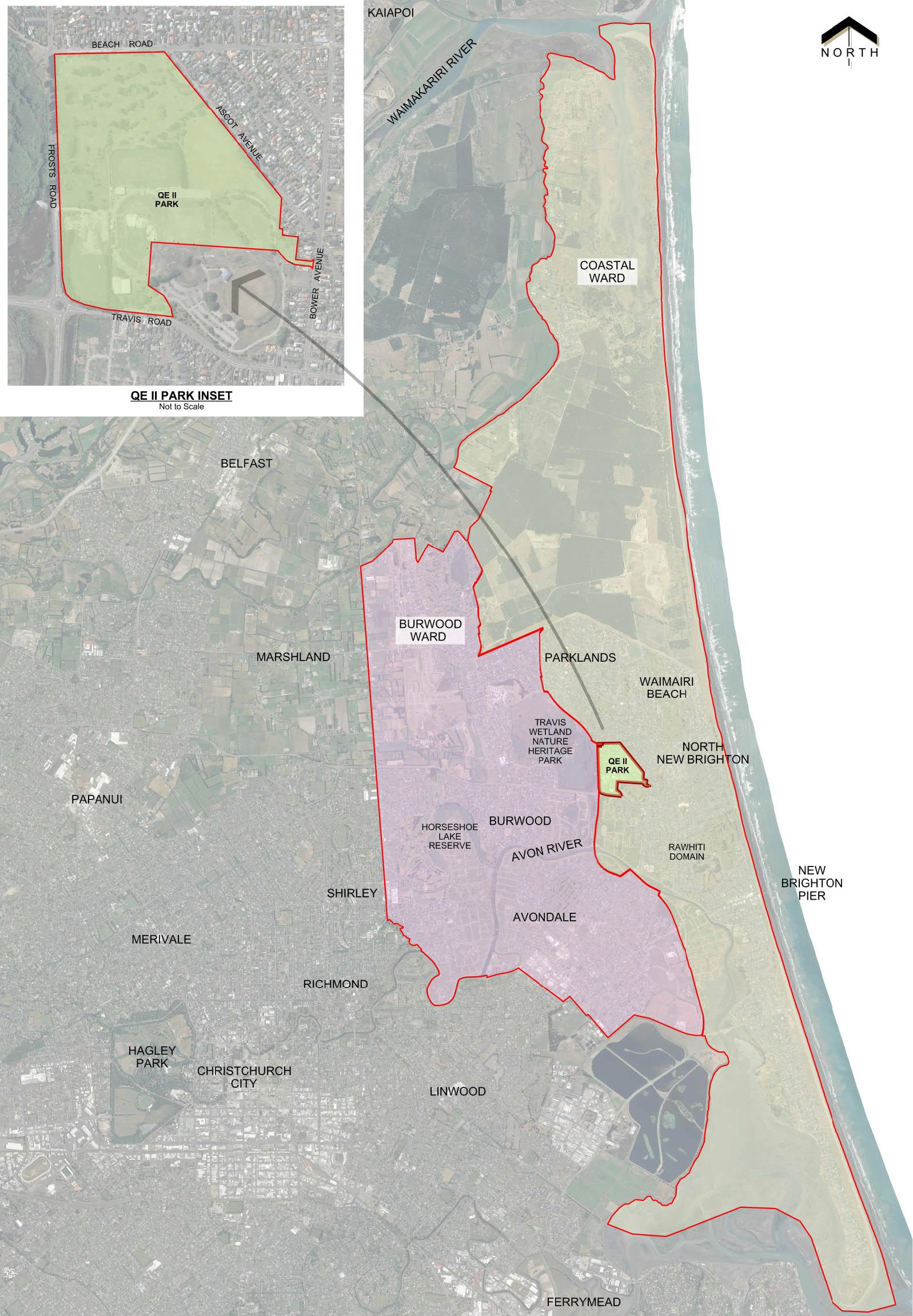
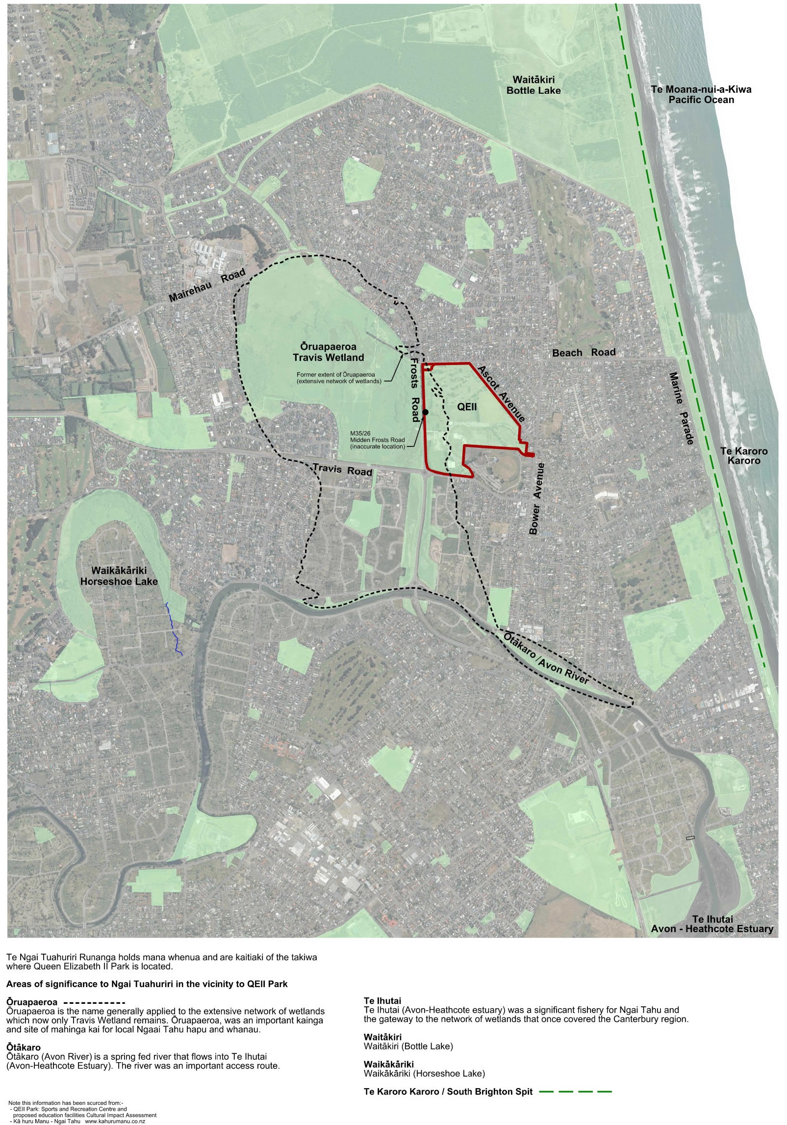
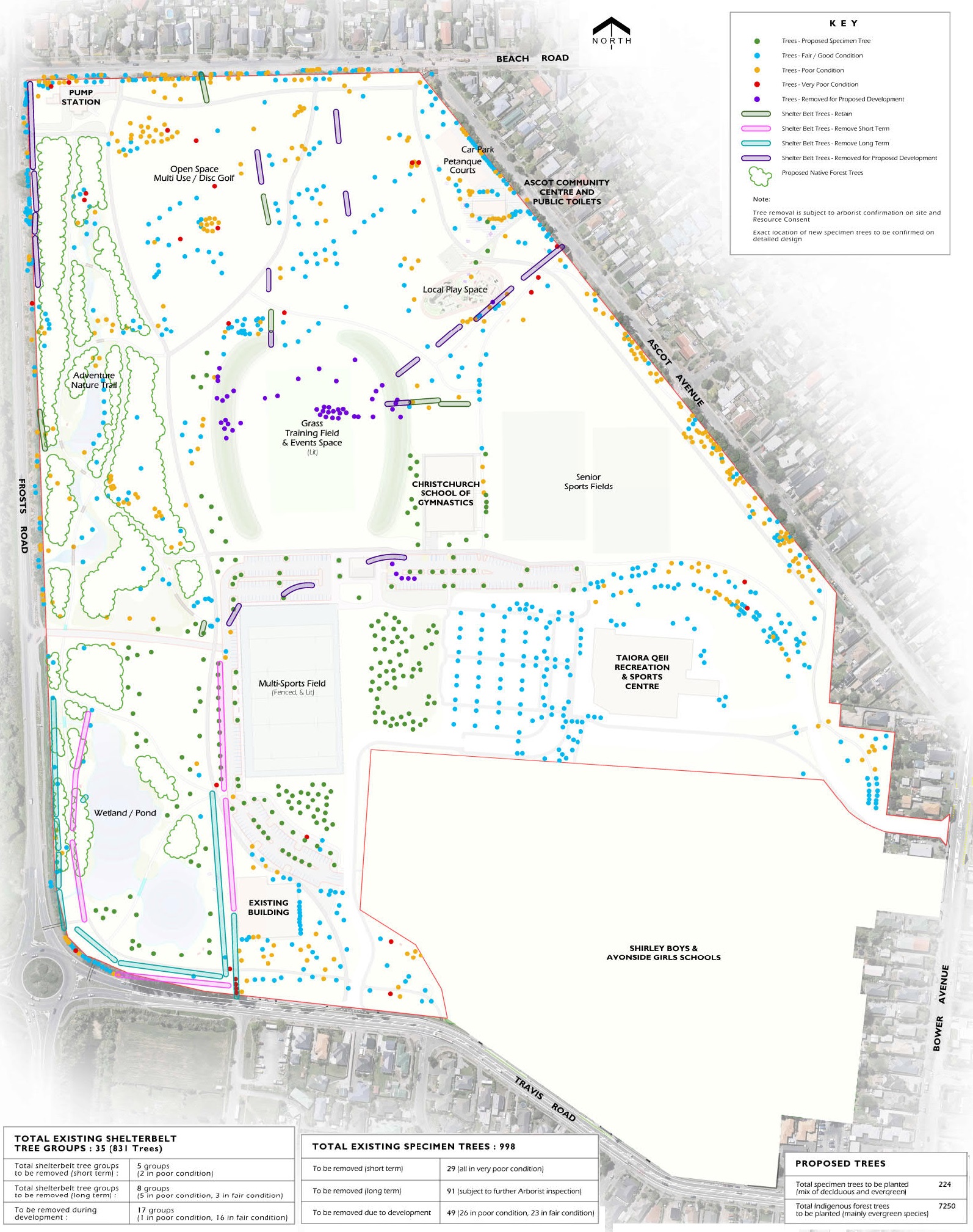
After the earthquakes, a number of damaged buildings and facilities located on QEII Park were demolished. Buildings and facilities currently in the park, which includes new builds as well as the ones that were there pre-earthquake, vary in quality and age. The table below identifies current buildings and facilities located on QEII Park.
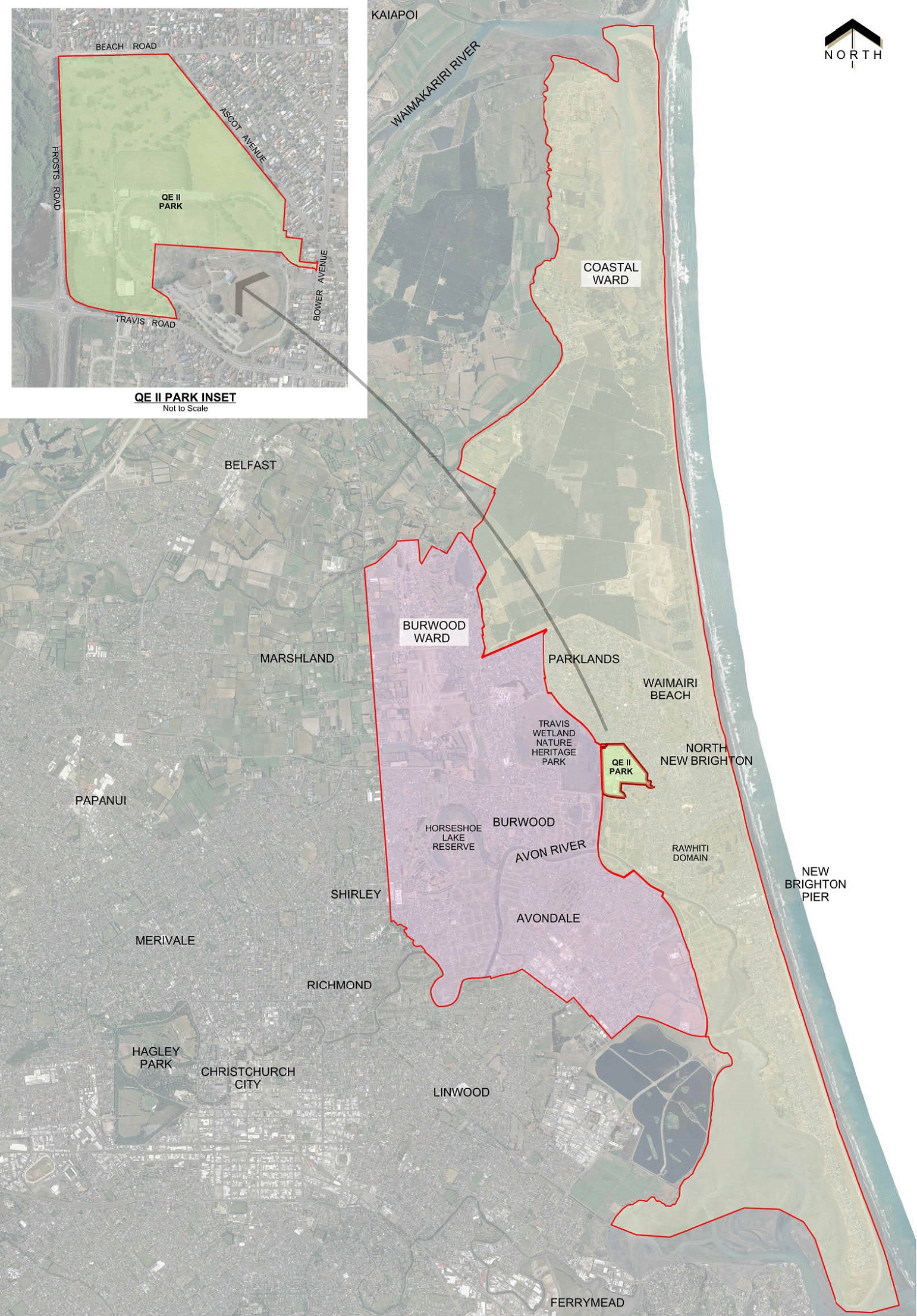
 

Buildings

Taiora: QEII Recreation and Sports Centre

Ascot Community Centre

Pump Station

Current Christchurch School of Gymnastics (CSG) Building

New CSG Building (under construction)

Former main park workshop (to be demolished)

Former greenkeeper’s workshop (to be demolished)

Former pump house (to be demolished)

Former sand shed (to be demolished)

Facilities

Internal car parking

Internal road network

Sports fields:

-          Two senior grass playing fields

-          One lit grass training field

-          One baseball diamond (summer)

Fitness track with stations

Petanque courts

Bench seating

Dog bins

Perimeter fencing

Park signage


To zoom in on the image, click on it to open and then hold Ctrl and tap + (and Ctrl and - to zoom out again)

Or you might like to download the PDF versions below:

QEII Park land quality PDF [JPG, 1.5 MB]

QEII Park location plan PDF [JPG, 1 MB]

QEII Park site history PDF [JPG, 1.3 MB]

QEII Park tree plan PDF [JPG, 860 KB]

Location

Share this

Who to contact

How the decision is made

  • Decision made

Takiuru ki ā mātou ratonga
Log in to our services