A brief summary of the history and background of the OARC, both pre- and post- earthquakes.
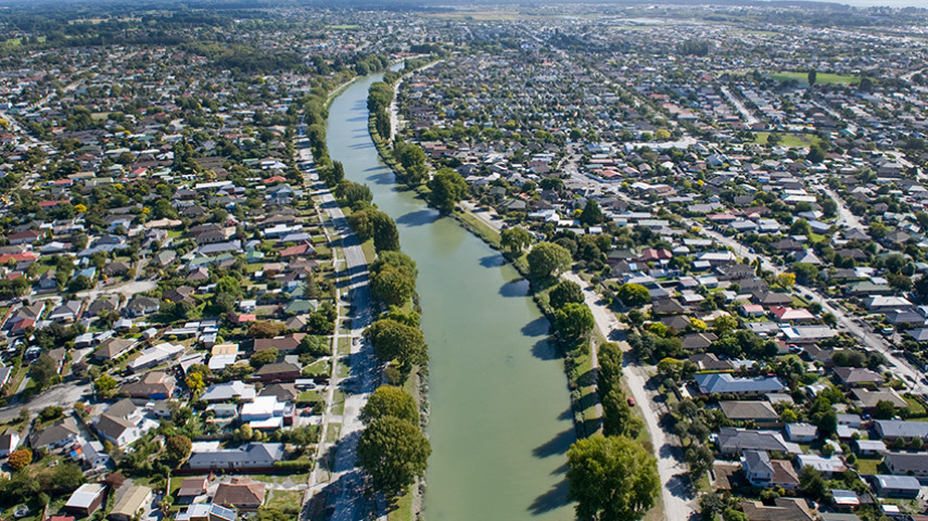
At 602 hectares, the Ōtākaro Avon River Corridor regeneration area is three-and-a-half times larger than Hagley Park.
Although this will be a generational project that’s likely to take between 30 and 50 years to fully develop, we encourage people to visit and connect with the land that once held more than 5,000 homes.
The Ōtākaro Avon River and surrounding area have a long and vibrant cultural history. Ngāi Tahu – and Ngāti Māmoe and Waitaha before them – had permanent and temporary kainga and pa in the greater Christchurch area. The Ōtākaro Avon River and Ihutai/Avon Heathcote Estuary are of vital importance to mana whenua, who prized the abundant food and natural resources that could be harvested from the springs, waterways, wetlands, grasslands, and forests that flourished in the area.
In the 19th and early 20th centuries, the Ōtākaro Avon River was often used for recreation and boating, with trout fishing being a popular past-time until fish numbers dwindled due to a decline in their food source and water quality from stormwater and wastewater entering the catchment.
Water quality is a high priority for the Council and we’re concentrating on improving the quality of the Ōtākaro Avon River’s water. Prior to the 2010 and 2011 earthquakes, the area was home to thousands of people, communities, businesses and schools.
The September 2010 and February 2011 earthquakes severely affected the area, with the Government classifying the 602 hectares as a residential red zone. This meant the land had experienced significant and extensive damage, there was uncertainty about the success of any potential engineering solution given ongoing seismic activity, and repairs would be disrupted and protracted for property owners, impacting their health and wellbeing.
Within the red zone area, the owners of almost 5,500 properties accepted Crown offers to purchase their properties and remove them from the Ōtākaro Avon River Corridor.
Between 2017 and 2019, Crown-and-Council-funded planning organisation Regenerate Christchurch commissioned a significant number of reports and assessments and undertook extensive community and stakeholder engagement to develop a Regeneration Plan for the Ōtākaro Avon River Corridor(external link). This plan was approved by the Minister for Greater Christchurch Regeneration, Megan Woods, in August 2019.
Christchurch City Council submitted investment cases to both the Crown and the Christchurch Earthquake Appeal Trust for funding to kick-start the development of the Regeneration Area, and received $40 million from the Canterbury Regeneration Acceleration Fund and $13.7 million from the Appeal Trust.
The riverside Dallington Landing, Snell Bridge, Avondale Bridge and Medway Bridge, which were completed in 2022, were funded by this grant.
Regenerating the 602-hectare Ōtākaro Avon River Corridor is a one-in-a-lifetime opportunity to create a legacy that benefits future generations. Stretching from the city to the sea, the 11km regeneration area contains streets, lawns and gardens that used to make up people’s properties.
The area’s potential is exciting and could provide a range of environmental, social and commercial benefits, as we explore ways to protect homes from the effects of climate change and sea-level rise, and make the Ōtākaro Avon River a healthier place for people and wildlife.
Transforming the area into a valuable asset for Christchurch won’t happen overnight. Given the scale of the Regeneration Area (it’s three-and-a-half times bigger than Hagley Park), and the costs of implementation, we estimate it will take 30-50 years to complete this development.
View the Regeneration Plan’s Greenprint (external link)(external link) of how the entire Ōtākaro Avon River Corridor could look in the future.
The Green Spine will form the core of the regeneration area. At 11km long, it will follow the Ōtākaro Avon River and feature swathes of restored native habitat, trails, paths, footbridges, community spaces, and riverside landings that provide access to the water and local information about the area.
The Council is developing a staged process to the planning construction and implementation of the Green Spine.
Over the past two years, Council staff, organisations and volunteers have planted tens of thousands of native trees throughout the Green Spine, as we begin bringing the vision of an ecologically-restored river corridor to life.
At the same time, engineering reports and decisions about stopbank and stormwater basin placement are underway. This needs to be completed so that stopbank construction and placement are carefully considered and don’t preclude any other land uses.
Work on the Green Spine and OARC is already underway – you can read more about the projects we've already completed(external link).
Land title reconfiguration
The responsibility for consolidating the land titles was part of the Global Settlement Agreement negotiations between the Crown and Council.
It was agreed that before any development can take place in the Ōtākaro Avon River Corridor, Toitu Whenua - Land Information New Zealand would undertake the important project of reconfiguring nearly 5,500 land boundaries. This is happening progressively, with the land being delivered to Council in tranches.
Road and pipes
The Council will not automatically remove existing infrastructure, such as roads and pipes.
We need to work through thousands of easements on titles and consider what’s required. We’ll consider removing buried infrastructure, such as pipes and cables, on a case-by-case basis.
Our obligation is to continue providing Council services to those who have opted to continue living within the Regeneration Area. If required, we’ll seek to engage with these private property owners in the future.
Maintenance
The Council’s Global Settlement Report (Section 14.1.2) outlines that from 1 July 2020, $2.7 million has been budgeted annually for maintenance, plus rates, for all of the residential red zones. As also noted in the Council report in section 14.1.1, capital costs have been budgeted for some time.
The amount that has been budgeted is enough to cover this maintenance.