A walkway along the coast, connecting Ferrymead to Scarborough.
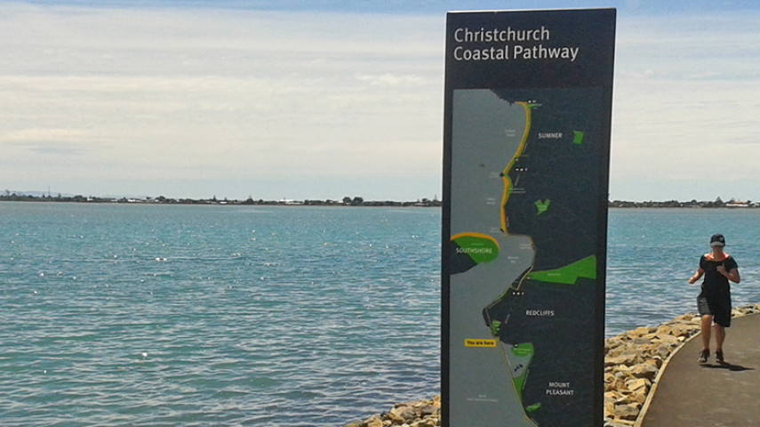
The Christchurch Coastal Pathway was a community-driven project that, with Council support and funding, successfully delivered a world-class, 6.5-kilometre-long shared walkway that lets people enjoy the estuary while travelling the coastline from Ferrymead to Scarborough Beach.
The wide pathway offers a safe, off-road option for pedestrians, cyclists, skateboarders, and people using scooters, wheelchairs and pushing strollers.
For more information, you can visit the Christchurch Coastal Pathway(external link) website.
Start: Scott Park car park
Finish: Tram stop, Moncks Bay
Distance: 3.3 km
Time: 35 minutes one way
Dogs: On leash
Toilets: Redcliffs Park
Access: Wheelchair accessible, shared pathway
Description:
The four-metre wide pathway starts at Scott Park beside the Ferrymead Bridge; there is car parking here.
The pathway follows the coastal edge for the length of McCormacks Bay causeway. It is shared use with pedestrians and cyclists, and suitable for wheelchairs and strollers. Features include a large macrocarpa tree, which is a popular roost for shags and the numerous wading birds that use the mudflats. Oyster-catchers are common, while godwits and royal spoonbills are seasonal visitors.
At the end of the causeway, follow the coast along Beachville Road on the footpath and continue to Redcliffs Village. This section of the walk ends at the old tram stop at Moncks Bay.
Start: Tram stop at Moncks Bay
Finish: Rapanui Shag Rock
Distance: 850 m
Time: 15 minutes one way
Dogs: On leash
Access: Not suitable for wheelchairs, strollers or cyclists
Description:
This section begins at the historic tram stop in Moncks Bay.
Follow the rough single track around the bay to Rapanui Shag Rock. This section is only suitable for pedestrians. Cyclists must be on the road.
Start: Rapanui Shag Rock
Finish: Near Tuawera Cave Rock, Sumner
Distance: 800 m
Time: 15 minutes one way
Dogs: On leash
Toilets: Sumner Beach
Access: Suitable for wheelchairs and strollers
Description:
A new mix of boardwalk and wide asphalt path suitable for cyclists, pedestrians, wheelchairs and strollers.
From Rapanui Shag Rock, enjoy a stroll along the coast past Clifton Beach until you reach the Sumner Promenade.
Spot nesting boxes for blue flippered penguins and native landscape planting for wildlife.
Continue to Scarborough along the Sumner Promenade.
Walking tracks
Shared use
Connecting tracks
Closed

Parking

Bus stop

Toilets
Water fountains
Accessible tracks

Challenging feature

Entry and exit point

Point of interest